more stats
1,106 ft
Distance
3 ft
Climb
-151 ft
Descent
00:03:49
Avg time
-148 ft
Altitude change
278 ft
Altitude min
428 ft
Altitude max
428 ft
Altitude start
282 ft
Altitude end
-13.4%
Grade
-46.2%
Grade max
4.3%
Grade min
82 ft
Distance climb
1,024 ft
Distance down
00:03:49
Avg time

Chuck Norris Details

  • Activities
    • Mountain Bike
    • Hike
    • Trail Running
  • Riding Area
    Diamond Hill
    Cumberland, Rhode Island
  • Difficulty Rating
  • Local Popularity
    70 in Mountain Biking [+]
    • 80 in Trail Running
    • 90 in Hiking
  • Global Ranking
    #44049 in Mountain Biking [+]
    • #56076 in Trail Running
    • #76306 in Hiking
  • Trail Type
    Singletrack
  • Bike Type
    DH, AM
  • Direction
    Downhill Only
    Popular Direction Shown
  • Physical Rating
    Hard
  • Dogs Allowed
    Yes
  • TTFs on Trail
    Bridge, Drop, Jump, Rock Face

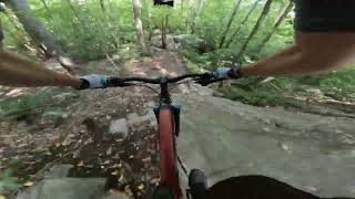
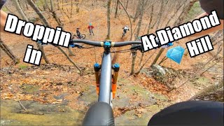
Chuck Norris, Paul's Masterpiece While some would claim that Chuck is a facist DB, this is one of the most enjoyable trails at Diamond Hill. The trails starts as for Rhody Flow and Clyde frog, and goes left right after the turn off of Clyde Frog. The top of the trail has a very small berm to berm gap that leads into a steep section with a drop, followed by a few chunky rock rollers that bring you down to the '295' landing and leading into a stepdown jump, then a steep roller to the ending wooden bridge jump. The end of the xc loop/ the dinner mint trail merges onto Chuck Norris right after the 295 ramp. Awesome, true downhill style trail with a lot going on!

Local Trail Association
Traditionally Indigenous Territory

Recent Activity on Trail

Past Week
  • 1 rides
  • 4 miles average
6 Months
  • 21 rides
  • 7 miles avg distance
All
  • 475 rides
  • Last: Jun 21, 2026
c1c2c3c4
January
February
March
April
May
June
July
August
September
October
November
December
update trails status or condition

Chuck Norris Trail Reports

statusdatedescription
Nov 29, 2025 @ 2:51pm (America/New_York)
Nov 29, 2025
wooden kicker is out of commission
Nov 1, 2025 @ 2:21pm (America/New_York)
Nov 1, 2025
Aug 8, 2025 @ 2:16pm
Aug 8, 2025
More ladder boards are now snapped/separated. Be sure to inspect before sending the roll, do not hit this blind right now!
Aug 3, 2025 @ 4:05pm
Aug 3, 2025
All good but it can get confusing at the top with trail splits and the cannon at the bottom is not ridable
Jul 23, 2025 @ 3:40pm
Jul 23, 2025
Some new broken boards at the beginning of the roller.
more »
Status:
on Nov 29, 2025
Variable
Avg: 4.31 (13 votes)
Your vote: 0

view (2,519)
close
3D
Trail Conditions
  • Unknown
  • Snow Groomed
  • Snow Packed
  • Snow Covered
  • Snow Cover Partial
  • Freeze/thaw Cycle
  • Icy
  • Prevalent Mud
  • Wet
  • Variable
  • Ideal
  • Dry
  • Very Dry
Trail Flow (Ridden Direction)
Trailforks scans users ridelogs to determine the most popular direction each trail is ridden. A good flowing trail network will have most trails flowing in a single direction according to their intension.
The colour categories are based on what percentage of riders are riding a trail in its intended direction.
  • > 96%
  • > 90%
  • > 80%
  • > 70%
  • > 50%
  • < 50%
  • bi-directional trail
  • no data
Trail Last Ridden
Trailforks scans ridelogs to determine the last time a trail was ridden.
  • < 2 days
  • < 1 week
  • < 2 weeks
  • < 1 month
  • < 6 months
  • > 6 months
Trail Ridden Direction
The intended direction a trail should be ridden.
  • Downhill Only
  • Downhill Primary
  • Both Directions
  • Uphill Primary
  • Uphill Only
  • One Direction
Contribute Details
Colors indicate trail is missing specified detail.
  • Description
  • Photos
  • Description & Photos
  • Videos
Trail Popularity ?
Trailforks scans ridelogs to determine which trails are ridden the most in the last 9 months. Trails are compared with nearby trails in the same city region with a possible 25 colour shades. Think of this as a heatmap, more rides = more kinetic energy = warmer colors.
  • most popular
  • popular
  • less popular
  • not popular
ATV/ORV/OHV Filter
Max Vehicle Width
inches
US Cell Coverage
Legend
cell carrier legend

Radar Time
Activity Recordings
Trailforks uses anonymized public activity data. ?
Activity Recordings
Trailforks uses anonymized public activity data. ?
Personal Heatmap
Activity Types
all / none
Options
2
Date range month
Winter Trails
Warning A routing network for winter maps does not exist. Selecting trails using the winter trails layer has been disabled.
Missing Trails
Most Popular
Least Popular
Trails are colored based on popularity. The more popular a trail is, the more red. Less popular trails trend towards green.
Jump Magnitude Heatmap
Heatmap of where riders jump on trails. Zoom in to see individual jumps, click circles to view jump details.
BC Backroad Status

Service Road Atlas is a free to use, community-driven service for viewing and creating reports on the numerous back-country service roads around B.C. and Alberta.

map legend
Slope Aspect
Direction the slope faces
Flat N NE E SE S SW W NW
Trails Deemphasized
Trails are shown in grey.
disable
Only show trails with no bike usage.
Enable
Suggested Layers
Based on selected activity type

    Save the current map location and zoom level as your default home location whenever this page is loaded.

    Save
        Directions to chuck-norris trailhead (42.003190, -71.426400)

        Photos

        21 more »
        792 |
        Apr 18, 2016 @ 7:56am
        Apr 18, 2016
        975 |
        Apr 20, 2016 @ 1:11pm
        Apr 20, 2016
        167 |
        Mar 4, 2023 @ 5:14pm
        Mar 4, 2023
        1,073 |
        Apr 16, 2017 @ 3:43pm
        Apr 16, 2017

        Videos

        19 more »
        Chuck Norris to Parking Lot - Diamond Hill RI
        3:09 | 415 | Nov 21, 2023 , Cumberland
        youtuber Droppin in at Diamond Hill | Enduro trails in...
        11:40 | 777 | Oct 5, 2020 , Cumberland
        Chuck Norris Save
        0:14 | 306 | May 4, 2021 , Cumberland
        Matt Holmes rips a downhill trail
        0:24 | 662 | Jun 11, 2017 , Cumberland

        Routes with this trail

        5 miles 900 ft 12
        This is the "enduro" loop for the 2023 Fun Ride
        2.0 5 miles 902 ft 14
        RINEMBA Fun Ride for 2022. Enduro Loop.
        5 miles 974 ft 15
        Diamond Hill practice route for WOAH gravity team.

        3 Reviews & Comments


        We hope you've been enjoying Trailforks!

        Create a FREE account to view trail comments and much more.

        Frequently Asked Questions About Chuck Norris

        Where is Chuck Norris located?
        Chuck Norris is located in Diamond Hill, Cumberland, Rhode Island, United States. It is part of the Diamond Hill trail network. The trailhead is located at coordinates 42.00319, -71.4264.
        How hard is Chuck Norris?
        Chuck Norris is rated as Double Black Diamond difficulty. The physical rating is Hard. The average grade is 13.4%.
        What is the elevation gain for Chuck Norris?
        Chuck Norris has 3 ft of elevation gain. The trail has 151 ft of elevation descent. The elevation ranges from 278 ft to 428 ft.
        Is Chuck Norris a point to point trail?
        Yes, Chuck Norris is a point to point trail. The direction is Downhill Only. The trail type is singletrack.

        Hit the Trail

        Open in App

        Get this trail on your phone instantly.
        open trail in app

        Download Trail

        Save to wishlist, Garmin & download.
        save the trail

        Find Related Routes

        Find routes and users activities that include this trail.
        find routes for this trail

        You must enter a description before submitting.