


Open in App
Get this trail on your phone instantly.

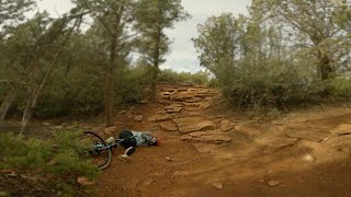
Beginner 10%, intermediate 50% and advanced 40%, 5.29 mile MTB trail which is a bi-directional singletrack that is twisty, buffed and up and down trail with some technical climbing sections you may need to walk. The trail tread is mostly packed dirt mixed with rocks and several lengthy sections of slickrock. There is no preferred direction and the trail is a great connector for several other fun loops. Pretty generic by Sedona standards. Equestrian use is restricted as posted at northwest section of trail. Equestrians can continue to the Brins Mesa Wilderness area or reverse back.
Section from Dry Creek Connector to Mescal is all good, but the rest of the trail will definitely require assistance. Suspension and clearance needed
| c1 | c2 | c3 | c4 |
|---|---|---|---|
January | February | March | April |
May | June | July | August |
September | October | November | December |

Service Road Atlas is a free to use, community-driven service for viewing and creating reports on the numerous back-country service roads around B.C. and Alberta.
Save the current map location and zoom level as your default home location whenever this page is loaded.
SaveWe hope you've been enjoying Trailforks!
Create a FREE account to view trail comments and much more.
You must enter a description before submitting.

