more stats
3,871 ft
Distance
10 ft
Climb
-426 ft
Descent
00:03:52
Avg time
-416 ft
Altitude change
975 ft
Altitude min
1,391 ft
Altitude max
1,391 ft
Altitude start
974 ft
Altitude end
-10.7%
Grade
-34.6%
Grade max
9.4%
Grade min
338 ft
Distance climb
2,897 ft
Distance down
636 ft
Distance flat
00:03:52
Avg time

Cinderella Details

  • Activities
    • Mountain Bike
    • Gravel Bike
    • Hike
    • Trail Running
  • Riding Area
    Joaquin Miller Park (JMP)
    Oakland, California
  • Difficulty Rating
  • Voted Difficulty
    Blue (23 votes)
  • Local Popularity
    100 in Mountain Biking [+]
    • 45 in Trail Running
    • 60 in Hiking
  • Global Ranking
    #7399 in Mountain Biking [+]
    • #74996 in Trail Running
    • #39578 in Hiking
  • Trail Type
    Singletrack
  • Bike Type
    DH, AM, XC, Gravel
  • Direction
    Downhill Primary
    Popular Direction Shown
  • Physical Rating
    Moderate
  • Trail Visibility
    Always easy to follow
  • Family Friendly
    Yes
  • Dogs Allowed
    Yes
  • eBike Allowed
  • TTFs on Trail
    Berm, Jump, Rock Garden
  • Ride in Rain
    Yes
  • Land Owner
    City of Oakland

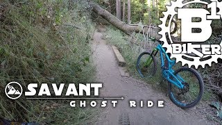
This trail between Bayview Sequoia and Sunset Trail is a flowy downhill trail. For new or intermediate riders, it has features that are quite technical. Several of them come up fast without clean sight lines. Take it easy on your first ride.

The trail can be very fast when ridden to potential. It has some (side of the trail) kickers (all of which can be avoided), one relatively steep rock garden section. Stay to the far left if you want an easier route. Don't ride the right line through the rock garden unless you are a capable rider. This is the section that gives it a black diamond rating, and the evil sister moniker.

BTCEB built a reroute near the bottom that includes some tight turns (read switchbacks). If you visit Joaquin Miller Park this is a must ride trail.

It is rated Black due to relative difficulty to other JMP blue trails.

Local Trail Association
Traditionally Indigenous Territory

Recent Activity on Trail

Past Week
  • 13 rides
  • 11 miles average
6 Months
  • 252 rides
  • 11 miles avg distance
All
  • 2,566 rides
  • Last: Jun 13, 2026
c1c2c3c4
January
February
March
April
May
June
July
August
September
October
November
December
Status:
on Jun 4, 2026
Very Dry
Avg: 4.04 (64 votes)
Your vote: 0

view (24,412)
close
3D
Trail Conditions
  • Unknown
  • Snow Groomed
  • Snow Packed
  • Snow Covered
  • Snow Cover Partial
  • Freeze/thaw Cycle
  • Icy
  • Prevalent Mud
  • Wet
  • Variable
  • Ideal
  • Dry
  • Very Dry
Trail Flow (Ridden Direction)
Trailforks scans users ridelogs to determine the most popular direction each trail is ridden. A good flowing trail network will have most trails flowing in a single direction according to their intension.
The colour categories are based on what percentage of riders are riding a trail in its intended direction.
  • > 96%
  • > 90%
  • > 80%
  • > 70%
  • > 50%
  • < 50%
  • bi-directional trail
  • no data
Trail Last Ridden
Trailforks scans ridelogs to determine the last time a trail was ridden.
  • < 2 days
  • < 1 week
  • < 2 weeks
  • < 1 month
  • < 6 months
  • > 6 months
Trail Ridden Direction
The intended direction a trail should be ridden.
  • Downhill Only
  • Downhill Primary
  • Both Directions
  • Uphill Primary
  • Uphill Only
  • One Direction
Contribute Details
Colors indicate trail is missing specified detail.
  • Description
  • Photos
  • Description & Photos
  • Videos
Trail Popularity ?
Trailforks scans ridelogs to determine which trails are ridden the most in the last 9 months. Trails are compared with nearby trails in the same city region with a possible 25 colour shades. Think of this as a heatmap, more rides = more kinetic energy = warmer colors.
  • most popular
  • popular
  • less popular
  • not popular
ATV/ORV/OHV Filter
Max Vehicle Width
inches
US Cell Coverage
Legend
cell carrier legend

Radar Time
Activity Recordings
Trailforks uses anonymized public activity data. ?
Activity Recordings
Trailforks uses anonymized public activity data. ?
Personal Heatmap
Activity Types
all / none
Options
2
Date range month
Winter Trails
Warning A routing network for winter maps does not exist. Selecting trails using the winter trails layer has been disabled.
Missing Trails
Most Popular
Least Popular
Trails are colored based on popularity. The more popular a trail is, the more red. Less popular trails trend towards green.
Jump Magnitude Heatmap
Heatmap of where riders jump on trails. Zoom in to see individual jumps, click circles to view jump details.
BC Backroad Status

Service Road Atlas is a free to use, community-driven service for viewing and creating reports on the numerous back-country service roads around B.C. and Alberta.

map legend
Slope Aspect
Direction the slope faces
Flat N NE E SE S SW W NW
Trails Deemphasized
Trails are shown in grey.
disable
Only show trails with no bike usage.
Enable
Suggested Layers
Based on selected activity type

    Save the current map location and zoom level as your default home location whenever this page is loaded.
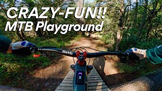
    Save
        Directions to cinderella-4914 trailhead (37.816380, -122.182000)

        Photos

        21 more »
        108 |
        Oct 20, 2025 @ 7:20pm
        Oct 20, 2025
        554 |
        Feb 13, 2023 @ 1:07pm
        Feb 13, 2023
        538 |
        Jun 14, 2022 @ 9:16pm
        Jun 14, 2022
        531 |
        Jun 14, 2022 @ 9:15pm
        Jun 14, 2022

        Videos

        53 more »
        youtuber Savant Ghost Ride - Various Trails - Joaquin...
        15:46 | 1301 | Aug 11, 2017 , Oakland
        youtuber RAD MTB Jumps & Flow at Joaquin Miller –...
        13:53 | 168 | Sep 23, 2025 , Oakland
        Joaquin Miller Park, Cinderella in 4K
        4:37 | 553 | Oct 31, 2022 , Oakland
        Joaquin Miller Park | Cinderella Trail
        2:14 | 906 | Jun 22, 2022 , Oakland

        Routes with this trail

        4.7 8 miles 1,194 ft 30 Loop
        Starts at Ranger station parking lot at 3540 Sanborn Dr, Oakland, CA. Uses to get to . Climbs up , cruises...
        4.0 10 miles 1,479 ft 7 Out & Back
        Smorgasbord of easy, fun doubletrack mixed with a few short, kick your ass climbs and some techy rock...
        31 miles 4,331 ft 12 Loop
        A solid ride loop that has mostly cross country trails with some black diamonds in JMP, Cinderella and...

        21 Reviews & Comments


        We hope you've been enjoying Trailforks!

        Create a FREE account to view trail comments and much more.

        Frequently Asked Questions About Cinderella

        Where is Cinderella located?
        Cinderella is located in Joaquin Miller Park (JMP), Oakland, California, United States. It is part of the Joaquin Miller Park (JMP) trail network. The trailhead is located at coordinates 37.81638, -122.182.
        How hard is Cinderella?
        Cinderella is rated as Black Diamond difficulty. The physical rating is Moderate. The average grade is 10.7%.
        What is the elevation gain for Cinderella?
        Cinderella has 10 ft of elevation gain. The trail has 426 ft of elevation descent. The elevation ranges from 975 ft to 1,391 ft.
        Is Cinderella a point to point trail?
        Cinderella is not a point to point trail. The direction is Downhill Primary. The trail type is singletrack.

        Hit the Trail

        Open in App

        Get this trail on your phone instantly.
        open trail in app

        Download Trail

        Save to wishlist, Garmin & download.
        save the trail

        Find Related Routes

        Find routes and users activities that include this trail.
        find routes for this trail

        You must enter a description before submitting.