more stats
4,654 ft
Distance
2 ft
Climb
-838 ft
Descent
00:05:05
Avg time
-836 ft
Altitude change
1,132 ft
Altitude min
1,969 ft
Altitude max
1,969 ft
Altitude start
1,132 ft
Altitude end
-17.975%
Grade
-32.186%
Grade max
3.583%
Grade min
50 ft
Distance climb
4,554 ft
Distance down
50 ft
Distance flat
00:05:05
Avg time

Cinghiale 2.0 Details

  • Activities
    • Mountain Bike
    • E-Bike
  • Riding Area
    Alpe di Poti
    Arezzo
  • Difficulty Rating
  • Local Popularity
    95 in Mountain Biking [+]
    • 95 in E-Biking
  • Global Ranking
    #43577 in Mountain Biking [+]
    • #15399 in E-Biking
  • Trail Type
    Singletrack
  • Bike Type
    DH, AM
  • Direction
    Downhill Only
    Popular Direction Shown
  • Climb Difficulty
    Blue
  • Physical Rating
    Hard
  • Season
    Gen-Dic
  • eBike Allowed
    Yes up to Class 1
  • TTFs on Trail
    Berm, Drop, Jump, Gap Jump, Rock Face

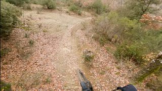
Il sentiero enduro più famoso di Arezzo, da fare assolutamente E' il classico sentiero che si fa al rientro dopo aver girato sui trail dell'Alpe di Poti. E' stato prova speciale del Toscano Enduro Series per due anni, nel 2017 e nel 2018.
E' un trail veloce e fisico, con segmenti con rocce e radici, in cui conoscere dove mettere le ruote è fondamentale.

The most famous enduro trail in Arezzo, a must do! It was a special stage of the Tuscan Enduro Series for two years, in 2017 and 2018.
It is a fast and physical trail, with rocks and roots, where knowing where to put your wheels is really important.

Access Info

Take the fire road on the left after Peneto. Then ride for half a mile and on the right you should see a trail head.

Recent Activity on Trail

Past Week
  • 0 rides
  •  
6 Months
  • 7 rides
  • 25 miles avg distance
All
  • 30 rides
  • Last: Jun 7, 2026
c1c2c3c4
January
February
March
April
May
June
July
August
September
October
November
December
update trails status or condition

Cinghiale 2.0 Trail Reports

Status:
on Apr 6, 2025
Ideal
Avg: 4.09 (4 votes)
Your vote: 0

view (1,232)
close
3D
Trail Conditions
  • Unknown
  • Snow Groomed
  • Snow Packed
  • Snow Covered
  • Snow Cover Partial
  • Freeze/thaw Cycle
  • Icy
  • Prevalent Mud
  • Wet
  • Variable
  • Ideal
  • Dry
  • Very Dry
Trail Flow (Ridden Direction)
Trailforks scans users ridelogs to determine the most popular direction each trail is ridden. A good flowing trail network will have most trails flowing in a single direction according to their intension.
The colour categories are based on what percentage of riders are riding a trail in its intended direction.
  • > 96%
  • > 90%
  • > 80%
  • > 70%
  • > 50%
  • < 50%
  • bi-directional trail
  • no data
Trail Last Ridden
Trailforks scans ridelogs to determine the last time a trail was ridden.
  • < 2 days
  • < 1 week
  • < 2 weeks
  • < 1 month
  • < 6 months
  • > 6 months
Trail Ridden Direction
The intended direction a trail should be ridden.
  • Downhill Only
  • Downhill Primary
  • Both Directions
  • Uphill Primary
  • Uphill Only
  • One Direction
Contribute Details
Colors indicate trail is missing specified detail.
  • Description
  • Photos
  • Description & Photos
  • Videos
Trail Popularity ?
Trailforks scans ridelogs to determine which trails are ridden the most in the last 9 months. Trails are compared with nearby trails in the same city region with a possible 25 colour shades. Think of this as a heatmap, more rides = more kinetic energy = warmer colors.
  • most popular
  • popular
  • less popular
  • not popular
ATV/ORV/OHV Filter
Max Vehicle Width
inches
US Cell Coverage
Legend
cell carrier legend

Radar Time
Activity Recordings
Trailforks uses anonymized public activity data. ?
Activity Recordings
Trailforks uses anonymized public activity data. ?
Personal Heatmap
Activity Types
all / none
Options
2
Date range month
Winter Trails
Warning A routing network for winter maps does not exist. Selecting trails using the winter trails layer has been disabled.
Missing Trails
Most Popular
Least Popular
Trails are colored based on popularity. The more popular a trail is, the more red. Less popular trails trend towards green.
Jump Magnitude Heatmap
Heatmap of where riders jump on trails. Zoom in to see individual jumps, click circles to view jump details.
BC Backroad Status

Service Road Atlas is a free to use, community-driven service for viewing and creating reports on the numerous back-country service roads around B.C. and Alberta.

map legend
Slope Aspect
Direction the slope faces
Flat N NE E SE S SW W NW
Trails Deemphasized
Trails are shown in grey.
disable
Only show trails with no bike usage.
Enable
Suggested Layers
Based on selected activity type

    Save the current map location and zoom level as your default home location whenever this page is loaded.

    Save
        Directions to cinghiale-2-0 trailhead (43.457840, 11.945900)

        Photos

        No photos have been added for Cinghiale 2.0 yet, add a photo.

        Videos

        3 more »
        Anti-WorldKnoll + Cinghiale - Alpe di Poti |...
        5:18 | 305 | Jan 20, 2023 , Arezzo
        Cinghiale 2018 TES #2 - AREZZO  PS3
        5:27 | 546 | Jan 15, 2020 , Arezzo
        Fun Riding W/ 'Il Babbo'
        705 | Oct 16, 2016 , Arezzo

        2 Reviews & Comments


        We hope you've been enjoying Trailforks!

        Create a FREE account to view trail comments and much more.

        • By ILLORY99 & contributors
        • #68319 - 2,563 views

        Frequently Asked Questions About Cinghiale 2.0

        Where is Cinghiale 2.0 located?
        Cinghiale 2.0 is located in Alpe di Poti, Arezzo, Italy. It is part of the Alpe di Poti trail network. The trailhead is located at coordinates 43.45784, 11.9459.
        How hard is Cinghiale 2.0?
        Cinghiale 2.0 is rated as Red difficulty. The physical rating is Hard. The average grade is 17.975%. The climb difficulty is rated Blue.
        What is the elevation gain for Cinghiale 2.0?
        Cinghiale 2.0 has 2 ft of elevation gain. The trail has 838 ft of elevation descent. The elevation ranges from 1,132 ft to 1,969 ft.
        Is Cinghiale 2.0 a point to point trail?
        Yes, Cinghiale 2.0 is a point to point trail. The direction is Downhill Only. The trail type is singletrack.

        Hit the Trail

        Open in App

        Get this trail on your phone instantly.
        open trail in app

        Download Trail

        Save to wishlist, Garmin & download.
        save the trail

        Find Related Routes

        Find routes and users activities that include this trail.
        find routes for this trail

        You must enter a description before submitting.