more stats
3,376 ft
Distance
3 ft
Climb
-520 ft
Descent
00:09:10
Avg time
-518 ft
Altitude change
656 ft
Altitude min
1,174 ft
Altitude max
1,174 ft
Altitude start
656 ft
Altitude end
-15.3%
Grade
-42.7%
Grade max
4.6%
Grade min
167 ft
Distance climb
3,146 ft
Distance down
66 ft
Distance flat
00:09:10
Avg time

Cliff Claven Details

  • Activities
    • Mountain Bike
    • E-Bike
  • Riding Area
    Thunder Mountain Bike Park
    Charlemont, Massachusetts
  • Difficulty Rating
  • Voted Difficulty
    Double Black Diamond (5 votes)
  • Local Popularity
    55 in Mountain Biking [+]
    • 90 in E-Biking
  • Global Ranking
    #7934 in Mountain Biking
  • Trail Type
    Singletrack
  • Bike Type
    DH, AM
  • Direction
    Downhill Only[+]
    Popular Direction Shown
    • Downhill Only for E-Biking
  • eBike Allowed
    Yes up to Class 1
  • TTFs on Trail
    Rock Face, Rock Garden
  • Year Opened
    2019
  • Land Owner
    Jon Schaefer

Some fun chutes.

In the winter, the best & most daring tree skiers will love this line. There are a myriad of cliffs and rocks to drop, including 2 large ones (the last one is a MTB drop and has a conspicuous sign ahead of it). Some pushing will be needed, but this line will show you some of the very best tough tree skiing on this mountain. Double-diamond difficulty in the winter.

Bike Park

Traditionally Indigenous Territory

Recent Activity on Trail

Past Week
  • 5 rides
  • 27 miles average
6 Months
  • 13 rides
  • 22 miles avg distance
All
  • 197 rides
  • Last: Jun 13, 2026
c1c2c3c4
January
February
March
April
May
June
July
August
September
October
November
December
Status:
on May 23, 2026
Ideal
Avg: 4.53 (9 votes)
Your vote: 0

view (2,037)
close
3D
Trail Conditions
  • Unknown
  • Snow Groomed
  • Snow Packed
  • Snow Covered
  • Snow Cover Partial
  • Freeze/thaw Cycle
  • Icy
  • Prevalent Mud
  • Wet
  • Variable
  • Ideal
  • Dry
  • Very Dry
Trail Flow (Ridden Direction)
Trailforks scans users ridelogs to determine the most popular direction each trail is ridden. A good flowing trail network will have most trails flowing in a single direction according to their intension.
The colour categories are based on what percentage of riders are riding a trail in its intended direction.
  • > 96%
  • > 90%
  • > 80%
  • > 70%
  • > 50%
  • < 50%
  • bi-directional trail
  • no data
Trail Last Ridden
Trailforks scans ridelogs to determine the last time a trail was ridden.
  • < 2 days
  • < 1 week
  • < 2 weeks
  • < 1 month
  • < 6 months
  • > 6 months
Trail Ridden Direction
The intended direction a trail should be ridden.
  • Downhill Only
  • Downhill Primary
  • Both Directions
  • Uphill Primary
  • Uphill Only
  • One Direction
Contribute Details
Colors indicate trail is missing specified detail.
  • Description
  • Photos
  • Description & Photos
  • Videos
Trail Popularity ?
Trailforks scans ridelogs to determine which trails are ridden the most in the last 9 months. Trails are compared with nearby trails in the same city region with a possible 25 colour shades. Think of this as a heatmap, more rides = more kinetic energy = warmer colors.
  • most popular
  • popular
  • less popular
  • not popular
ATV/ORV/OHV Filter
Max Vehicle Width
inches
US Cell Coverage
Legend
cell carrier legend

Radar Time
Activity Recordings
Trailforks uses anonymized public activity data. ?
Activity Recordings
Trailforks uses anonymized public activity data. ?
Personal Heatmap
Activity Types
all / none
Options
2
Date range month
Winter Trails
Warning A routing network for winter maps does not exist. Selecting trails using the winter trails layer has been disabled.
Missing Trails
Most Popular
Least Popular
Trails are colored based on popularity. The more popular a trail is, the more red. Less popular trails trend towards green.
Jump Magnitude Heatmap
Heatmap of where riders jump on trails. Zoom in to see individual jumps, click circles to view jump details.
BC Backroad Status

Service Road Atlas is a free to use, community-driven service for viewing and creating reports on the numerous back-country service roads around B.C. and Alberta.

map legend
Slope Aspect
Direction the slope faces
Flat N NE E SE S SW W NW
Trails Deemphasized
Trails are shown in grey.
disable
Only show trails with no bike usage.
Enable
Suggested Layers
Based on selected activity type

    Save the current map location and zoom level as your default home location whenever this page is loaded.

    Save
        Directions to cliff-claven trailhead (42.619730, -72.869180)

        Photos

        3 more »
        506 |
        Aug 22, 2020 @ 4:35pm
        Aug 22, 2020
        392 |
        Jul 15, 2020 @ 2:28pm
        Jul 15, 2020
        343 |
        Sep 29, 2019 @ 6:41pm
        Sep 29, 2019

        Videos

        4 more »
        youtuber Most INSANE Moments of 2022! (Pt. 3) - 'Land...
        11:01 | 249 | Mar 9, 2023 , Charlemont
        Loamstar to Cliff Claven || Thunder Mountain...
        9:32 | 327 | Aug 14, 2021 , Charlemont
        Cliff Claven - Thunder Mountain Bike Park
        2:18 | 629 | Sep 16, 2020 , Charlemont
        Friday Fails Rock Roll
        0:07 | 247 | Nov 9, 2020 , Charlemont

        Trail Lists

        1 Review & Comments


        We hope you've been enjoying Trailforks!

        Create a FREE account to view trail comments and much more.

        • By nikodemusTF Pro & contributors
        • #208582 - 2,284 views

        Frequently Asked Questions About Cliff Claven

        Where is Cliff Claven located?
        Cliff Claven is located in Thunder Mountain Bike Park, Charlemont, Massachusetts, United States. It is part of the Thunder Mountain Bike Park trail network. The trailhead is located at coordinates 42.61973, -72.86918.
        How hard is Cliff Claven?
        Cliff Claven is rated as Double Black Diamond difficulty. The average grade is 15.3%.
        What is the elevation gain for Cliff Claven?
        Cliff Claven has 3 ft of elevation gain. The trail has 520 ft of elevation descent. The elevation ranges from 656 ft to 1,174 ft.
        Is Cliff Claven a point to point trail?
        Yes, Cliff Claven is a point to point trail. The direction is Downhill Only. The trail type is singletrack.

        Hit the Trail

        Open in App

        Get this trail on your phone instantly.
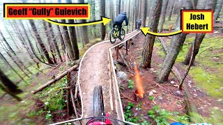
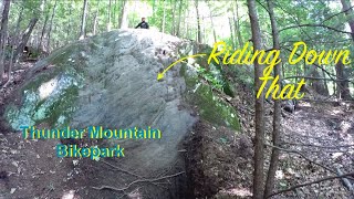
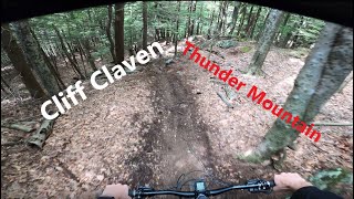
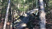
        open trail in app

        Download Trail

        Save to wishlist, Garmin & download.
        save the trail

        Find Related Routes

        Find routes and users activities that include this trail.
        find routes for this trail

        You must enter a description before submitting.