


Open in App
Get this trail on your phone instantly.

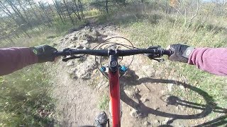
Start at the intersection of the Carriage Trail and Cliff-Top Trail and head south for about 1.5 kilometres of fast, flowy, and somewhat technical singletrack descending. The trail twists its way down from the top of the escarpment, with some roots and rock outcroppings and the occasional steep section before it ends at the southern end of the park. The trail is rideable on a hardtail, although somewhat bumpy.
Keep in mind that this is also a hiking trail, and it is not uncommon to come around a corner to find a group of hikers, so stay in control of your speed.
Horse allowed only on most northern portion of trail.
| c1 | c2 | c3 | c4 |
|---|---|---|---|
January | February | March | April |
May | June | July | August |
September | October | November | December |

Service Road Atlas is a free to use, community-driven service for viewing and creating reports on the numerous back-country service roads around B.C. and Alberta.
Save the current map location and zoom level as your default home location whenever this page is loaded.
SaveWe hope you've been enjoying Trailforks!
Create a FREE account to view trail comments and much more.
You must enter a description before submitting.

