more stats
1,263 ft
Distance
-170 ft
Descent
00:03:40
Avg time
-170 ft
Altitude change
275 ft
Altitude min
445 ft
Altitude max
445 ft
Altitude start
276 ft
Altitude end
-13.4%
Grade
-23.6%
Grade max
-4.6%
Grade min
1,263 ft
Distance down
00:03:40
Avg time

Clyde Frog Details

  • Activities
    • Mountain Bike
    • Hike
    • Trail Running
  • Riding Area
    Diamond Hill
    Cumberland, Rhode Island
  • Difficulty Rating
  • Voted Difficulty
    Black Diamond (2 votes)
  • Local Popularity
    95 in Mountain Biking [+]
    • 85 in Trail Running
    • 50 in Hiking
  • Global Ranking
    #39095 in Mountain Biking [+]
    • #35455 in Trail Running
    • #96403 in Hiking
  • Trail Type
    Singletrack
  • Bike Type
    DH
  • Direction
    Downhill Only
    Popular Direction Shown
  • Physical Rating
    Extreme
  • Dogs Allowed
    Yes
  • TTFs on Trail
    Drop, Jump

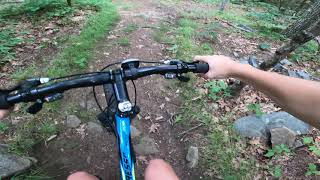
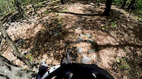
Clyde Frog starts off the beginning of Rhody flow and goes straight where Chuck Norris and Rhody Flow turn right. The trail follows the fall line with the quarry on your left and eventually leads you off of a concrete slab commonly referred to as 'the loading dock' It then hits a bermed left turn and leads into a small stepdown at the end of the trail and intersects with the climb back up to the top. The concrete slab is actually a cap to an old copper mine shaft.

Local Trail Association
Traditionally Indigenous Territory

Recent Activity on Trail

Past Week
  • 3 rides
  • 6 miles average
6 Months
  • 45 rides
  • 7 miles avg distance
All
  • 856 rides
  • Last: Jun 28, 2026
c1c2c3c4
January
February
March
April
May
June
July
August
September
October
November
December
update trails status or condition

Clyde Frog Trail Reports

statusdatedescription
Aug 3, 2025 @ 4:06pm
Aug 3, 2025
Sep 5, 2024 @ 3:12pm
Sep 5, 2024
Dry / loose in some spots.
Aug 5, 2023 @ 10:19am
Aug 5, 2023
Top half is freshly clipped. Running well. Broken glass is being addressed, too.
Jul 22, 2023 @ 9:25am
Jul 22, 2023
There’s some broken glass on the landing off the loading dock. I tried to remove the loose pieces, but a rake is needed to get rid of the...
Apr 22, 2023 @ 3:10am
Apr 22, 2023
more »
Status:
on Aug 3, 2025
Variable
Avg: 4.46 (9 votes)
Your vote: 0

view (4,254)
close
3D
Trail Conditions
  • Unknown
  • Snow Groomed
  • Snow Packed
  • Snow Covered
  • Snow Cover Partial
  • Freeze/thaw Cycle
  • Icy
  • Prevalent Mud
  • Wet
  • Variable
  • Ideal
  • Dry
  • Very Dry
Trail Flow (Ridden Direction)
Trailforks scans users ridelogs to determine the most popular direction each trail is ridden. A good flowing trail network will have most trails flowing in a single direction according to their intension.
The colour categories are based on what percentage of riders are riding a trail in its intended direction.
  • > 96%
  • > 90%
  • > 80%
  • > 70%
  • > 50%
  • < 50%
  • bi-directional trail
  • no data
Trail Last Ridden
Trailforks scans ridelogs to determine the last time a trail was ridden.
  • < 2 days
  • < 1 week
  • < 2 weeks
  • < 1 month
  • < 6 months
  • > 6 months
Trail Ridden Direction
The intended direction a trail should be ridden.
  • Downhill Only
  • Downhill Primary
  • Both Directions
  • Uphill Primary
  • Uphill Only
  • One Direction
Contribute Details
Colors indicate trail is missing specified detail.
  • Description
  • Photos
  • Description & Photos
  • Videos
Trail Popularity ?
Trailforks scans ridelogs to determine which trails are ridden the most in the last 9 months. Trails are compared with nearby trails in the same city region with a possible 25 colour shades. Think of this as a heatmap, more rides = more kinetic energy = warmer colors.
  • most popular
  • popular
  • less popular
  • not popular
ATV/ORV/OHV Filter
Max Vehicle Width
inches
US Cell Coverage
Legend
cell carrier legend

Radar Time
Activity Recordings
Trailforks uses anonymized public activity data. ?
Activity Recordings
Trailforks uses anonymized public activity data. ?
Personal Heatmap
Activity Types
all / none
Options
2
Date range month
Winter Trails
Warning A routing network for winter maps does not exist. Selecting trails using the winter trails layer has been disabled.
Missing Trails
Most Popular
Least Popular
Trails are colored based on popularity. The more popular a trail is, the more red. Less popular trails trend towards green.
Jump Magnitude Heatmap
Heatmap of where riders jump on trails. Zoom in to see individual jumps, click circles to view jump details.
BC Backroad Status

Service Road Atlas is a free to use, community-driven service for viewing and creating reports on the numerous back-country service roads around B.C. and Alberta.

map legend
Slope Aspect
Direction the slope faces
Flat N NE E SE S SW W NW
Trails Deemphasized
Trails are shown in grey.
disable
Only show trails with no bike usage.
Enable
Suggested Layers
Based on selected activity type

    Save the current map location and zoom level as your default home location whenever this page is loaded.

    Save
        Directions to clyde-frog trailhead (42.003510, -71.426750)

        Photos

        9 more »
        486 |
        Sep 27, 2020 @ 5:51am
        Sep 27, 2020
        1,071 |
        May 20, 2016 @ 4:01am
        May 20, 2016
        322 |
        Mar 11, 2021 @ 1:19pm
        Mar 11, 2021
        337 |
        Sep 27, 2020 @ 5:51am
        Sep 27, 2020

        Videos

        8 more »
        Diamond Hill
        5:12 | 246 | Aug 26, 2023 , Cumberland
        Platform jump/drop
        0:23 | 496 | Jul 4, 2016 , Cumberland
        Diamond Hill jumps 01
        2:16 | 400 | Dec 13, 2015 , Cumberland
        Diamond Hill
        2:14 | 1667 | Jul 20, 2014 , Cumberland

        Routes with this trail

        5 miles 900 ft 12
        This is the "enduro" loop for the 2023 Fun Ride
        2.0 5 miles 902 ft 14
        RINEMBA Fun Ride for 2022. Enduro Loop.
        5 miles 974 ft 15
        Diamond Hill practice route for WOAH gravity team.

        2 Reviews & Comments


        We hope you've been enjoying Trailforks!

        Create a FREE account to view trail comments and much more.

        • By jaywashTF Pro & contributors
        • #18674 - 4,632 views

        Frequently Asked Questions About Clyde Frog

        Where is Clyde Frog located?
        Clyde Frog is located in Diamond Hill, Cumberland, Rhode Island, United States. It is part of the Diamond Hill trail network. The trailhead is located at coordinates 42.00351, -71.42675.
        How hard is Clyde Frog?
        Clyde Frog is rated as Double Black Diamond difficulty. The physical rating is Extreme. The average grade is 13.4%.
        What is the elevation gain for Clyde Frog?
        The trail has 170 ft of elevation descent. The elevation ranges from 275 ft to 445 ft.
        Is Clyde Frog a point to point trail?
        Yes, Clyde Frog is a point to point trail. The direction is Downhill Only. The trail type is singletrack.

        Hit the Trail

        Open in App

        Get this trail on your phone instantly.
        open trail in app

        Download Trail

        Save to wishlist, Garmin & download.
        save the trail

        Find Related Routes

        Find routes and users activities that include this trail.
        find routes for this trail

        You must enter a description before submitting.