more stats
2,497 ft
Distance
26 ft
Climb
-31 ft
Descent
00:04:29
Avg time
-6 ft
Altitude change
3,539 ft
Altitude min
3,572 ft
Altitude max
3,544 ft
Altitude start
3,540 ft
Altitude end
-0.2%
Grade
-12.6%
Grade max
9%
Grade min
981 ft
Distance climb
774 ft
Distance down
741 ft
Distance flat
00:04:29
Avg time

CMBA Link Details

  • Activities
    • Mountain Bike
    • E-Bike
    • Hike
    • Trail Running
  • Riding Area
    Bowmont Park
    Calgary, Alberta
  • Difficulty Rating
  • Local Popularity
    95 in Mountain Biking [+]
    • 95 in E-Biking
    • 85 in Trail Running
    • 65 in Hiking
  • Global Ranking
    #32328 in Mountain Biking [+]
    • #16235 in E-Biking
    • #48905 in Trail Running
    • #89729 in Hiking
  • Trail Type
    Singletrack
  • Bike Type
    XC
  • Climb Difficulty
    Green
  • Physical Rating
    Easy
  • Dogs Allowed
    Yes
  • eBike Allowed
    Yes up to Class 1

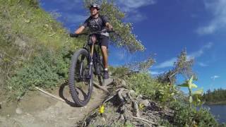
Built in 2016 by the Calgary Mountain Bike Alliance, this trail connects the Bowmont Single Track and Sideshow Bob. This is a reroute of existing trail, which can no longer be accessed due to a new storm water drainage system being built by the city.

Trail Supporters
Local Trail Association

Recent Activity on Trail

Past Week
  • 6 rides
  • 9 miles average
6 Months
  • 87 rides
  • 11 miles avg distance
All
  • 820 rides
  • Last: Jun 18, 2026
c1c2c3c4
January
February
March
April
May
June
July
August
September
October
November
December
Status:
on Jun 6, 2026
Dry
Avg: 3.49 (6 votes)
Your vote: 0

view (6,154)
close
3D
Trail Conditions
  • Unknown
  • Snow Groomed
  • Snow Packed
  • Snow Covered
  • Snow Cover Partial
  • Freeze/thaw Cycle
  • Icy
  • Prevalent Mud
  • Wet
  • Variable
  • Ideal
  • Dry
  • Very Dry
Trail Flow (Ridden Direction)
Trailforks scans users ridelogs to determine the most popular direction each trail is ridden. A good flowing trail network will have most trails flowing in a single direction according to their intension.
The colour categories are based on what percentage of riders are riding a trail in its intended direction.
  • > 96%
  • > 90%
  • > 80%
  • > 70%
  • > 50%
  • < 50%
  • bi-directional trail
  • no data
Trail Last Ridden
Trailforks scans ridelogs to determine the last time a trail was ridden.
  • < 2 days
  • < 1 week
  • < 2 weeks
  • < 1 month
  • < 6 months
  • > 6 months
Trail Ridden Direction
The intended direction a trail should be ridden.
  • Downhill Only
  • Downhill Primary
  • Both Directions
  • Uphill Primary
  • Uphill Only
  • One Direction
Contribute Details
Colors indicate trail is missing specified detail.
  • Description
  • Photos
  • Description & Photos
  • Videos
Trail Popularity ?
Trailforks scans ridelogs to determine which trails are ridden the most in the last 9 months. Trails are compared with nearby trails in the same city region with a possible 25 colour shades. Think of this as a heatmap, more rides = more kinetic energy = warmer colors.
  • most popular
  • popular
  • less popular
  • not popular
ATV/ORV/OHV Filter
Max Vehicle Width
inches
US Cell Coverage
Legend
cell carrier legend

Radar Time
Activity Recordings
Trailforks uses anonymized public activity data. ?
Activity Recordings
Trailforks uses anonymized public activity data. ?
Personal Heatmap
Activity Types
all / none
Options
2
Date range month
Winter Trails
Warning A routing network for winter maps does not exist. Selecting trails using the winter trails layer has been disabled.
Missing Trails
Most Popular
Least Popular
Trails are colored based on popularity. The more popular a trail is, the more red. Less popular trails trend towards green.
Jump Magnitude Heatmap
Heatmap of where riders jump on trails. Zoom in to see individual jumps, click circles to view jump details.
BC Backroad Status

Service Road Atlas is a free to use, community-driven service for viewing and creating reports on the numerous back-country service roads around B.C. and Alberta.

map legend
Slope Aspect
Direction the slope faces
Flat N NE E SE S SW W NW
Trails Deemphasized
Trails are shown in grey.
disable
Only show trails with no bike usage.
Enable
Suggested Layers
Based on selected activity type

    Save the current map location and zoom level as your default home location whenever this page is loaded.

    Save
        Directions to cmba-link trailhead (51.091340, -114.175430)

        Photos

        4 more »
        47 |
        Jun 17, 2022 @ 7:30pm
        Jun 17, 2022
        36 |
        Jun 17, 2022 @ 7:30pm
        Jun 17, 2022
        164 |
        May 28, 2020 @ 7:36pm
        May 28, 2020
        113 |
        Jul 22, 2018 @ 5:48am
        Jul 22, 2018

        Videos

        1 more »
        Go it Alone - Mountain Bike Trails Calgary
        1057 | Sep 8, 2016 , Calgary

        Routes with this trail

        5.0 7 miles 718 ft 9
        Great mix of technical single track and pathway. I prefer to do this trail as an out and back starting at...
        4 miles 388 ft 12
        Rip through Bowmont.........
        2.0 7 miles 540 ft 4 Out & Back
        #RideCMBA Bowmont Short Loop

        Reviews / Comments

        No reviews yet, be the first to write a review or ask a question.
        Use trail reports to comment on trail conditions.


        We hope you've been enjoying Trailforks!

        Create a FREE account to view trail comments and much more.

        • By Dirty-AlTF Pro & contributors
        • #66336 - 2,956 views

        Frequently Asked Questions About CMBA Link

        Where is CMBA Link located?
        CMBA Link is located in Bowmont Park, Calgary, Alberta, Canada. It is part of the Bowmont Park trail network. The trailhead is located at coordinates 51.09134, -114.17543.
        How hard is CMBA Link?
        CMBA Link is rated as Green difficulty. The physical rating is Easy. The average grade is 0.2%. The climb difficulty is rated Green.
        What is the elevation gain for CMBA Link?
        CMBA Link has 26 ft of elevation gain. The trail has 31 ft of elevation descent. The elevation ranges from 3,539 ft to 3,572 ft.
        How long is CMBA Link?
        CMBA Link is 2,497 ft long. The trail type is singletrack.

        Hit the Trail

        Open in App

        Get this trail on your phone instantly.
        open trail in app

        Download Trail

        Save to wishlist, Garmin & download.
        save the trail

        Find Related Routes

        Find routes and users activities that include this trail.
        find routes for this trail

        You must enter a description before submitting.