more stats
1.7 miles
Distance
5 ft
Climb
-76 ft
Descent
00:19:09
Avg time
-72 ft
Altitude change
4,593 ft
Altitude min
4,665 ft
Altitude max
4,665 ft
Altitude start
4,593 ft
Altitude end
-0.8%
Grade
-10.1%
Grade max
2.7%
Grade min
581 ft
Distance climb
2,352 ft
Distance down
1 mile
Distance flat
00:19:09
Avg time

Coastline Details

  • Activities
    • Mountain Bike
    • E-Bike
    • Horse
    • Hike
    • Trail Running
  • Riding Area
  • AKA
    Blue Trail, Blue Arrows
  • Difficulty Rating
  • Local Popularity
    90 in Mountain Biking [+]
    • 90 in E-Biking
    • 85 in Trail Running
    • 80 in Hiking
    • 5 in Horseback
  • Global Ranking
    #27209 in Mountain Biking [+]
    • #2658 in Trail Running
    • #37445 in Hiking
    • #994 in Horseback
  • Trail Type
    Singletrack
  • Bike Type
    AM, XC, Fat
  • Direction
    Both Directions[+]
    • Both Directions for Horseback
  • Trail Visibility
    Always easy to follow
  • Season
    Jan - Dec
  • Dogs Allowed
    Yes
  • eBike Allowed
    Yes up to Class 1
  • TTFs on Trail
    Berm, Jump
  • Land Owner

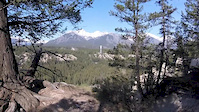
Cruisy singletrack cross country trail on the edge of the Tunnel Mountain bench that provides great views of the Bow Valley. Trail rides great in both directions but it faster and arguably more fun when ridden West to East. Although this is a beginner friendly trail with sections of intermediate difficulty, there are exposed sections that may unnerve beginner riders. Watch for optional "High Roller" blue line added in 2018. Trail is part of the Tunnel Bench loop with "The Spine" and Teddybears Picnic."

Local Trail Association

Recent Activity on Trail

Past Week
  • 1 rides
  • 16 miles average
6 Months
  • 18 rides
  • 12 miles avg distance
All
  • 520 rides
  • Last: Jun 15, 2026
c1c2c3c4
January
February
March
April
May
June
July
August
September
October
November
December
update trails status or condition

Coastline Trail Reports

Status:
on May 7, 2026
Avg: 4.12 (18 votes)
Your vote: 0

view (2,927)
close
3D
Trail Conditions
  • Unknown
  • Snow Groomed
  • Snow Packed
  • Snow Covered
  • Snow Cover Partial
  • Freeze/thaw Cycle
  • Icy
  • Prevalent Mud
  • Wet
  • Variable
  • Ideal
  • Dry
  • Very Dry
Trail Flow (Ridden Direction)
Trailforks scans users ridelogs to determine the most popular direction each trail is ridden. A good flowing trail network will have most trails flowing in a single direction according to their intension.
The colour categories are based on what percentage of riders are riding a trail in its intended direction.
  • > 96%
  • > 90%
  • > 80%
  • > 70%
  • > 50%
  • < 50%
  • bi-directional trail
  • no data
Trail Last Ridden
Trailforks scans ridelogs to determine the last time a trail was ridden.
  • < 2 days
  • < 1 week
  • < 2 weeks
  • < 1 month
  • < 6 months
  • > 6 months
Trail Ridden Direction
The intended direction a trail should be ridden.
  • Downhill Only
  • Downhill Primary
  • Both Directions
  • Uphill Primary
  • Uphill Only
  • One Direction
Contribute Details
Colors indicate trail is missing specified detail.
  • Description
  • Photos
  • Description & Photos
  • Videos
Trail Popularity ?
Trailforks scans ridelogs to determine which trails are ridden the most in the last 9 months. Trails are compared with nearby trails in the same city region with a possible 25 colour shades. Think of this as a heatmap, more rides = more kinetic energy = warmer colors.
  • most popular
  • popular
  • less popular
  • not popular
ATV/ORV/OHV Filter
Max Vehicle Width
inches
US Cell Coverage
Legend
cell carrier legend

Radar Time
Activity Recordings
Trailforks uses anonymized public activity data. ?
Activity Recordings
Trailforks uses anonymized public activity data. ?
Personal Heatmap
Activity Types
all / none
Options
2
Date range month
Winter Trails
Warning A routing network for winter maps does not exist. Selecting trails using the winter trails layer has been disabled.
Missing Trails
Most Popular
Least Popular
Trails are colored based on popularity. The more popular a trail is, the more red. Less popular trails trend towards green.
Jump Magnitude Heatmap
Heatmap of where riders jump on trails. Zoom in to see individual jumps, click circles to view jump details.
BC Backroad Status

Service Road Atlas is a free to use, community-driven service for viewing and creating reports on the numerous back-country service roads around B.C. and Alberta.

map legend
Slope Aspect
Direction the slope faces
Flat N NE E SE S SW W NW
Trails Deemphasized
Trails are shown in grey.
disable
Only show trails with no bike usage.
Enable
Suggested Layers
Based on selected activity type

    Save the current map location and zoom level as your default home location whenever this page is loaded.

    Save
        Directions to coastline trailhead (51.199430, -115.522590)

        Photos

        26 more »
        84 |
        Jun 18, 2023 @ 3:47pm
        Jun 18, 2023
        89 |
        Jun 18, 2023 @ 3:47pm
        Jun 18, 2023
        70 |
        Jun 18, 2023 @ 3:47pm
        Jun 18, 2023
        80 |
        Jun 18, 2023 @ 3:47pm
        Jun 18, 2023

        Videos

        1 more »
        The coast on Coastline
        2:50 | 446 | May 19, 2016 , Banff

        Routes with this trail

        5.0 15 miles 742 ft 8 Loop
        The Best Trails Banff Has to offer (E-bike accesable) Takes you through all my favorite routes.
        18 miles 1,118 ft 11 Point to Point
        Hopefully a good guide to riding all the tunnel bench trails in terms of the best/most fun direction to...
        14 miles 946 ft 8
        A Solid ~25k loop in Banff! Great to do if you're staying in town or camping

        10 Reviews & Comments


        We hope you've been enjoying Trailforks!

        Create a FREE account to view trail comments and much more.

        • By LipBombTF Pro BVMBA & contributors
        • #47798 - 8,549 views

        Frequently Asked Questions About Coastline

        Where is Coastline located?
        Coastline is located in Tunnel Mountain Bench Area, Banff, Alberta, Canada. It is part of the Tunnel Mountain Bench Area trail network. The trailhead is located at coordinates 51.19943, -115.52259.
        How hard is Coastline?
        Coastline is rated as Blue difficulty. The average grade is 0.8%.
        What is the elevation gain for Coastline?
        Coastline has 5 ft of elevation gain. The trail has 76 ft of elevation descent. The elevation ranges from 4,593 ft to 4,665 ft.
        Is Coastline a point to point trail?
        Coastline is not a point to point trail. The direction is Both Directions. The trail type is singletrack.

        Hit the Trail

        Open in App

        Get this trail on your phone instantly.
        open trail in app

        Download Trail

        Save to wishlist, Garmin & download.
        save the trail

        Find Related Routes

        Find routes and users activities that include this trail.
        find routes for this trail

        You must enter a description before submitting.