more stats
4,488 ft
Distance
41 ft
Climb
-421 ft
Descent
00:12:11
Avg time
-379 ft
Altitude change
5,495 ft
Altitude min
5,917 ft
Altitude max
5,917 ft
Altitude start
5,538 ft
Altitude end
-8.4%
Grade
-71.3%
Grade max
19.4%
Grade min
381 ft
Distance climb
3,944 ft
Distance down
164 ft
Distance flat
00:12:11
Avg time

Comet Details

  • Activities
    • Mountain Bike
    • E-Bike
  • Riding Area
    SkyPark at Santa's Village
    Skyforest, California
  • Difficulty Rating
  • Voted Difficulty
    Double Black Diamond (4 votes)
  • Local Popularity
    30 in Mountain Biking [+]
    • 35 in E-Biking
  • Global Ranking
    #96910 in Mountain Biking [+]
    • #94305 in E-Biking
  • Trail Type
    Singletrack
  • Bike Type
    DH, AM, XC
  • Direction
    Downhill Only
    Popular Direction Shown
  • Climb Difficulty
    Blue
  • Physical Rating
    Hard
  • Trail Visibility
    Always easy to follow
  • eBike Allowed
    Yes up to Class 1
  • TTFs on Trail
    Bridge, Drop, Ladder Bridge, Skinny

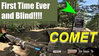
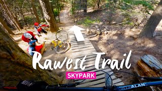
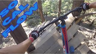
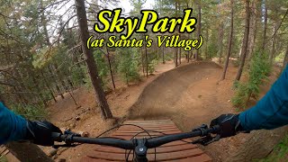
Comet is part of the Skypark bike park. The trail is a technical trail with bridge's and drops.
The trail is natural and ungroomed. Expect roots and loose rocks aplenty. It is the longest trail in the network and is not strictly downhill the entire way. This trail requires punchy climbing in multiple sections. The rider will be challenged by various wooden skinny obstacles, rooty drops in switchbacks, a tricky wooden drop feature and a step-up jump.

Access Info

Access through Skypark.

Disclaimer

Not suitable for aMTB

Trail Supporters

  • USFS
    Land Manager

Bike Park

Traditionally Indigenous Territory

Recent Activity on Trail

Past Week
  • 4 rides
  • 16 miles average
6 Months
  • 27 rides
  • 12 miles avg distance
All
  • 401 rides
  • Last: Jun 20, 2026
c1c2c3c4
January
February
March
April
May
June
July
August
September
October
November
December
update trails status or condition

Comet Trail Reports

Status:
on Jun 9, 2025
Dry
Avg: 4.56 (17 votes)
Your vote: 0

view (9,117)
close
3D
Trail Conditions
  • Unknown
  • Snow Groomed
  • Snow Packed
  • Snow Covered
  • Snow Cover Partial
  • Freeze/thaw Cycle
  • Icy
  • Prevalent Mud
  • Wet
  • Variable
  • Ideal
  • Dry
  • Very Dry
Trail Flow (Ridden Direction)
Trailforks scans users ridelogs to determine the most popular direction each trail is ridden. A good flowing trail network will have most trails flowing in a single direction according to their intension.
The colour categories are based on what percentage of riders are riding a trail in its intended direction.
  • > 96%
  • > 90%
  • > 80%
  • > 70%
  • > 50%
  • < 50%
  • bi-directional trail
  • no data
Trail Last Ridden
Trailforks scans ridelogs to determine the last time a trail was ridden.
  • < 2 days
  • < 1 week
  • < 2 weeks
  • < 1 month
  • < 6 months
  • > 6 months
Trail Ridden Direction
The intended direction a trail should be ridden.
  • Downhill Only
  • Downhill Primary
  • Both Directions
  • Uphill Primary
  • Uphill Only
  • One Direction
Contribute Details
Colors indicate trail is missing specified detail.
  • Description
  • Photos
  • Description & Photos
  • Videos
Trail Popularity ?
Trailforks scans ridelogs to determine which trails are ridden the most in the last 9 months. Trails are compared with nearby trails in the same city region with a possible 25 colour shades. Think of this as a heatmap, more rides = more kinetic energy = warmer colors.
  • most popular
  • popular
  • less popular
  • not popular
ATV/ORV/OHV Filter
Max Vehicle Width
inches
US Cell Coverage
Legend
cell carrier legend

Radar Time
Activity Recordings
Trailforks uses anonymized public activity data. ?
Activity Recordings
Trailforks uses anonymized public activity data. ?
Personal Heatmap
Activity Types
all / none
Options
2
Date range month
Winter Trails
Warning A routing network for winter maps does not exist. Selecting trails using the winter trails layer has been disabled.
Missing Trails
Most Popular
Least Popular
Trails are colored based on popularity. The more popular a trail is, the more red. Less popular trails trend towards green.
Jump Magnitude Heatmap
Heatmap of where riders jump on trails. Zoom in to see individual jumps, click circles to view jump details.
BC Backroad Status

Service Road Atlas is a free to use, community-driven service for viewing and creating reports on the numerous back-country service roads around B.C. and Alberta.

map legend
Slope Aspect
Direction the slope faces
Flat N NE E SE S SW W NW
Trails Deemphasized
Trails are shown in grey.
disable
Only show trails with no bike usage.
Enable
Suggested Layers
Based on selected activity type

    Save the current map location and zoom level as your default home location whenever this page is loaded.

    Save
        Directions to comet-108056 trailhead (34.231370, -117.165700)

        Photos

        4 more »
        6,491 |
        Mar 11, 2018 @ 9:45pm
        Mar 11, 2018
        154 |
        Jul 18, 2020 @ 10:13am
        Jul 18, 2020
        399 |
        Aug 13, 2018 @ 11:11am
        Aug 13, 2018
        352 |
        Aug 13, 2018 @ 11:09am
        Aug 13, 2018

        Videos

        14 more »
        youtuber Bad idea??? Mountain Biking Comet Trail Blind...
        10:13 | 343 | Jul 13, 2023 , Skyforest
        youtuber Rawest Trail at Skypark at Santa's Village - Comet
        8:16 | 313 | May 15, 2021 , Skyforest
        youtuber COMET TRAIL AT SKYPARK - Is this really So Cal?
        6:50 | 900 | Jul 17, 2018 , Skyforest
        youtuber SkyPark at Santa's Village
        16:31 | 86 | May 16, 2025 , Skyforest

        Trail Lists

        4 Reviews & Comments


        We hope you've been enjoying Trailforks!

        Create a FREE account to view trail comments and much more.

        • By toddTF Pro Trailforks & contributors
        • #108056 - 4,482 views

        Frequently Asked Questions About Comet

        Where is Comet located?
        Comet is located in SkyPark at Santa's Village, Skyforest, California, United States. It is part of the SkyPark at Santa's Village trail network. The trailhead is located at coordinates 34.23137, -117.1657.
        How hard is Comet?
        Comet is rated as Double Black Diamond difficulty. The physical rating is Hard. The average grade is 8.4%. The climb difficulty is rated Blue.
        What is the elevation gain for Comet?
        Comet has 41 ft of elevation gain. The trail has 421 ft of elevation descent. The elevation ranges from 5,495 ft to 5,917 ft.
        Is Comet a point to point trail?
        Yes, Comet is a point to point trail. The direction is Downhill Only. The trail type is singletrack.

        Hit the Trail

        Open in App

        Get this trail on your phone instantly.
        open trail in app

        Download Trail

        Save to wishlist, Garmin & download.
        save the trail

        Find Related Routes

        Find routes and users activities that include this trail.
        find routes for this trail

        You must enter a description before submitting.