more stats
1.2 miles
Distance
79 ft
Climb
-594 ft
Descent
00:11:23
Avg time
-515 ft
Altitude change
1,885 ft
Altitude min
2,425 ft
Altitude max
2,401 ft
Altitude start
1,885 ft
Altitude end
-7.844%
Grade
-30.923%
Grade max
13.594%
Grade min
1,157 ft
Distance climb
4,653 ft
Distance down
759 ft
Distance flat
00:11:23
Avg time

Connector Details

  • Activities
    • Mountain Bike
    • Hike
    • Trail Running
  • Riding Area
    Crawford Trails
    Kelowna, British Columbia
  • Difficulty Rating
  • Voted Difficulty
    Black Diamond (3 votes)
  • Local Popularity
    100 in Mountain Biking [+]
    • 80 in Trail Running
    • 85 in Hiking
  • Global Ranking
    #16478 in Mountain Biking [+]
    • #74728 in Trail Running
    • #52732 in Hiking
  • Trail Type
    Singletrack
  • Bike Type
    DH, AM, XC
  • Dogs Allowed
    Yes

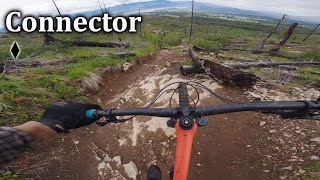
Rock and more rock, nothing overly technical, but there some moderately steep sections with small rock steps.
It can get loose and marblely at times.
Some short pedal sections, but it mostly sweet, sweet descents.
A great trail to finish a ride after a Vapour lap..

Trail Supporters
Local Trail Association

Recent Activity on Trail

Past Week
  • 9 rides
  • 9 miles average
6 Months
  • 218 rides
  • 8 miles avg distance
All
  • 2,441 rides
  • Last: Jun 29, 2026
c1c2c3c4
January
February
March
April
May
June
July
August
September
October
November
December
update trails status or condition

Connector Trail Reports

statusdatedescription
Jun 16, 2026 @ 6:38pm (America/Creston)
Jun 16, 2026
Jun 2, 2026 @ 4:39pm (America/Vancouver)
Jun 2, 2026
Mar 22, 2026 @ 9:45am (America/Vancouver)
Mar 22, 2026
Some damp rock near the top, but absolutely rideable
Feb 14, 2026 @ 12:08pm (America/Vancouver)
Feb 14, 2026
Feb 12, 2026 @ 1:24pm (America/Vancouver)
Feb 12, 2026
early spring conditions, very very very very muddy. Not the time to ride unless it is frozen
more »
Status:
on Jun 16, 2026
Dry
Avg: 4.18 (51 votes)
Your vote: 0

view (15,009)
close
3D
Trail Conditions
  • Unknown
  • Snow Groomed
  • Snow Packed
  • Snow Covered
  • Snow Cover Partial
  • Freeze/thaw Cycle
  • Icy
  • Prevalent Mud
  • Wet
  • Variable
  • Ideal
  • Dry
  • Very Dry
Trail Flow (Ridden Direction)
Trailforks scans users ridelogs to determine the most popular direction each trail is ridden. A good flowing trail network will have most trails flowing in a single direction according to their intension.
The colour categories are based on what percentage of riders are riding a trail in its intended direction.
  • > 96%
  • > 90%
  • > 80%
  • > 70%
  • > 50%
  • < 50%
  • bi-directional trail
  • no data
Trail Last Ridden
Trailforks scans ridelogs to determine the last time a trail was ridden.
  • < 2 days
  • < 1 week
  • < 2 weeks
  • < 1 month
  • < 6 months
  • > 6 months
Trail Ridden Direction
The intended direction a trail should be ridden.
  • Downhill Only
  • Downhill Primary
  • Both Directions
  • Uphill Primary
  • Uphill Only
  • One Direction
Contribute Details
Colors indicate trail is missing specified detail.
  • Description
  • Photos
  • Description & Photos
  • Videos
Trail Popularity ?
Trailforks scans ridelogs to determine which trails are ridden the most in the last 9 months. Trails are compared with nearby trails in the same city region with a possible 25 colour shades. Think of this as a heatmap, more rides = more kinetic energy = warmer colors.
  • most popular
  • popular
  • less popular
  • not popular
ATV/ORV/OHV Filter
Max Vehicle Width
inches
US Cell Coverage
Legend
cell carrier legend

Radar Time
Activity Recordings
Trailforks uses anonymized public activity data. ?
Activity Recordings
Trailforks uses anonymized public activity data. ?
Personal Heatmap
Activity Types
all / none
Options
2
Date range month
Winter Trails
Warning A routing network for winter maps does not exist. Selecting trails using the winter trails layer has been disabled.
Missing Trails
Most Popular
Least Popular
Trails are colored based on popularity. The more popular a trail is, the more red. Less popular trails trend towards green.
Jump Magnitude Heatmap
Heatmap of where riders jump on trails. Zoom in to see individual jumps, click circles to view jump details.
BC Backroad Status

Service Road Atlas is a free to use, community-driven service for viewing and creating reports on the numerous back-country service roads around B.C. and Alberta.

map legend
Slope Aspect
Direction the slope faces
Flat N NE E SE S SW W NW
Trails Deemphasized
Trails are shown in grey.
disable
Only show trails with no bike usage.
Enable
Suggested Layers
Based on selected activity type

    Save the current map location and zoom level as your default home location whenever this page is loaded.

    Save
        Directions to connector-19395 trailhead (49.803370, -119.424300)

        Photos

        47 more »
        274 |
        Aug 8, 2018 @ 10:26pm
        Aug 8, 2018
        290 |
        Sep 10, 2017 @ 11:18am
        Sep 10, 2017
        66 |
        Nov 30, 2024 @ 9:01pm
        Nov 30, 2024
        186 |
        May 31, 2022 @ 7:31am
        May 31, 2022

        Videos

        11 more »
        Great Trail With A Bad Name | Connector - Crawford
        7:23 | 277 | Oct 5, 2024 , Kelowna
        Crawford Mountain Biking: Vapour & Connector!
        4:07 | 1343 | Jul 9, 2022 , Kelowna
        Crawford MTB: Lost Lake & Pink Highway to...
        2:03 | 265 | Jul 4, 2022 , Kelowna
        Big Drop, Rocky Screech and Connector
        11:00 | 503 | Mar 13, 2022 , Kelowna

        Routes with this trail

        5.0 7 miles 1,584 ft 5 Loop
        This will be an “enduro-style” ride, with four downhill stages. The downhill stages are on blue and...
        3.0 4 miles 693 ft 11 Loop
        A tour of the lower trails. Great for a quick rip or to take beginners out to experience real trails.
        7 miles 1,323 ft 3 Loop
        Crawford's most technical trail is no joke. , has become a local favorite for it's super fast start,...

        3 Reviews & Comments


        We hope you've been enjoying Trailforks!

        Create a FREE account to view trail comments and much more.

        • By smokeTF Pro Simpcw & contributors
        • #19395 - 9,577 views

        Frequently Asked Questions About Connector

        Where is Connector located?
        Connector is located in Crawford Trails, Kelowna, British Columbia, Canada. It is part of the Crawford Trails trail network. The trailhead is located at coordinates 49.80337, -119.4243.
        How hard is Connector?
        Connector is rated as Black Diamond difficulty. The average grade is 7.844%.
        What is the elevation gain for Connector?
        Connector has 79 ft of elevation gain. The trail has 594 ft of elevation descent. The elevation ranges from 1,885 ft to 2,425 ft.
        How long is Connector?
        Connector is 1.2 miles long. The trail type is singletrack.

        Hit the Trail

        Open in App

        Get this trail on your phone instantly.
        open trail in app

        Download Trail

        Save to wishlist, Garmin & download.
        save the trail

        Find Related Routes

        Find routes and users activities that include this trail.
        find routes for this trail

        You must enter a description before submitting.