more stats
2,021 ft
Distance
-557 ft
Descent
00:05:21
Avg time
-557 ft
Altitude change
731 ft
Altitude min
1,287 ft
Altitude max
1,287 ft
Altitude start
732 ft
Altitude end
-27.5%
Grade
-64.5%
Grade max
2.1%
Grade min
75 ft
Distance climb
1,880 ft
Distance down
69 ft
Distance flat
00:05:21
Avg time

Cop Killer - Lower Details

  • Activities
    • Mountain Bike
    • E-Bike
    • Hike
    • Trail Running
  • Riding Area
    Mackenzie
    Pemberton, British Columbia
  • Difficulty Rating
  • Local Popularity
    60 in Mountain Biking [+]
    • 60 in E-Biking
    • 5 in Trail Running
    • 45 in Hiking
  • Global Ranking
    #91936 in Mountain Biking [+]
    • #63047 in E-Biking
    • #137421 in Trail Running
    • #107281 in Hiking
  • Hiking SAC Scale
    T3 Demanding Mountain Hiking
  • Trail Type
    Singletrack
  • Direction
    Downhill Only
    Popular Direction Shown
  • Dogs Allowed
    Yes
  • eBike Allowed
    Yes up to Class 1

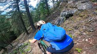
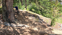
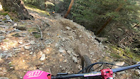
If you rode Upper Cop Killer you might as well ride this fun and still very steep and technical finish to Cop Killer. This trail runs super loose and dry in the summer months. Best ridden in Spring and the Fall.

Access Info

Stay alert as the junction comes up quick during a fast section of trail. After Upper Cop Killer joins up with Upper Mac, ride Upper Mac for several hundred fun and fast meters. Keep your eyes peeled for the junction on your right and drop into Lower Cop Killer

Local Trail Association
Traditionally Indigenous Territory

Recent Activity on Trail

Past Week
  • 0 rides
  •  
6 Months
  • 19 rides
  • 18 miles avg distance
All
  • 108 rides
  • Last: Jun 8, 2026
c1c2c3c4
January
February
March
April
May
June
July
August
September
October
November
December
update trails status or condition

Cop Killer - Lower Trail Reports

statusdatedescription
Sep 26, 2024 @ 1:28pm
Sep 26, 2024
tree down, comes up quick. just before sandy chute area
Jun 24, 2024 @ 11:25am
Jun 24, 2024
Oct 29, 2023 @ 11:57am
Oct 29, 2023
reporter
Sep 4, 2023 @ 4:59pm
Sep 4, 2023
Very very dry and loose. Be prepared to surf your way down.
May 7, 2022 @ 9:56am
May 7, 2022
more »
Status:
on Sep 26, 2024
Avg: 4.24 (10 votes)
Your vote: 0

view (752)
close
3D
Trail Conditions
  • Unknown
  • Snow Groomed
  • Snow Packed
  • Snow Covered
  • Snow Cover Partial
  • Freeze/thaw Cycle
  • Icy
  • Prevalent Mud
  • Wet
  • Variable
  • Ideal
  • Dry
  • Very Dry
Trail Flow (Ridden Direction)
Trailforks scans users ridelogs to determine the most popular direction each trail is ridden. A good flowing trail network will have most trails flowing in a single direction according to their intension.
The colour categories are based on what percentage of riders are riding a trail in its intended direction.
  • > 96%
  • > 90%
  • > 80%
  • > 70%
  • > 50%
  • < 50%
  • bi-directional trail
  • no data
Trail Last Ridden
Trailforks scans ridelogs to determine the last time a trail was ridden.
  • < 2 days
  • < 1 week
  • < 2 weeks
  • < 1 month
  • < 6 months
  • > 6 months
Trail Ridden Direction
The intended direction a trail should be ridden.
  • Downhill Only
  • Downhill Primary
  • Both Directions
  • Uphill Primary
  • Uphill Only
  • One Direction
Contribute Details
Colors indicate trail is missing specified detail.
  • Description
  • Photos
  • Description & Photos
  • Videos
Trail Popularity ?
Trailforks scans ridelogs to determine which trails are ridden the most in the last 9 months. Trails are compared with nearby trails in the same city region with a possible 25 colour shades. Think of this as a heatmap, more rides = more kinetic energy = warmer colors.
  • most popular
  • popular
  • less popular
  • not popular
ATV/ORV/OHV Filter
Max Vehicle Width
inches
US Cell Coverage
Legend
cell carrier legend

Radar Time
Activity Recordings
Trailforks uses anonymized public activity data. ?
Activity Recordings
Trailforks uses anonymized public activity data. ?
Personal Heatmap
Activity Types
all / none
Options
2
Date range month
Winter Trails
Warning A routing network for winter maps does not exist. Selecting trails using the winter trails layer has been disabled.
Missing Trails
Most Popular
Least Popular
Trails are colored based on popularity. The more popular a trail is, the more red. Less popular trails trend towards green.
Jump Magnitude Heatmap
Heatmap of where riders jump on trails. Zoom in to see individual jumps, click circles to view jump details.
BC Backroad Status

Service Road Atlas is a free to use, community-driven service for viewing and creating reports on the numerous back-country service roads around B.C. and Alberta.

map legend
Slope Aspect
Direction the slope faces
Flat N NE E SE S SW W NW
Trails Deemphasized
Trails are shown in grey.
disable
Only show trails with no bike usage.
Enable
Suggested Layers
Based on selected activity type

    Save the current map location and zoom level as your default home location whenever this page is loaded.

    Save
        Directions to cop-killer-lower trailhead (50.336980, -122.787700)

        Photos

        11 more »
        138 |
        Oct 14, 2019 @ 7:24am
        Oct 14, 2019
        156 |
        May 20, 2019 @ 11:32pm
        May 20, 2019
        207 |
        Apr 29, 2019 @ 8:40am
        Apr 29, 2019
        39 |
        Sep 26, 2024 @ 1:29pm
        Sep 26, 2024

        Videos

        3 more »
        Gabriels technical section by gabriel
        0:03 | 324 | Jun 30, 2020 , Pemberton
        Lower cop killer with gabriel
        0:02 | 59 | Jun 30, 2020 , Pemberton
        Friday Fail
        0:16 | 266 | Nov 3, 2019 , Pemberton

        Trail Lists

        Routes with this trail

        6 miles 1,984 ft 21
        My ride On YouTube on Cop Killer. Live2Ride Ep 3.

        Trail Products

        1 Review & Comments


        We hope you've been enjoying Trailforks!

        Create a FREE account to view trail comments and much more.

        • By flipfantasiaTF Pro WORCA & contributors
        • #175370 - 2,960 views

        Frequently Asked Questions About Cop Killer - Lower

        Where is Cop Killer - Lower located?
        Cop Killer - Lower is located in Mackenzie, Pemberton, British Columbia, Canada. It is part of the Mackenzie trail network. The trailhead is located at coordinates 50.33698, -122.7877.
        How hard is Cop Killer - Lower?
        Cop Killer - Lower is rated as Double Black Diamond difficulty. The average grade is 27.5%.
        What is the elevation gain for Cop Killer - Lower?
        The trail has 557 ft of elevation descent. The elevation ranges from 731 ft to 1,287 ft.
        Is Cop Killer - Lower a point to point trail?
        Yes, Cop Killer - Lower is a point to point trail. The direction is Downhill Only. The trail type is singletrack.

        Hit the Trail

        Open in App

        Get this trail on your phone instantly.
        open trail in app

        Download Trail

        Save to wishlist, Garmin & download.
        save the trail

        Find Related Routes

        Find routes and users activities that include this trail.
        find routes for this trail

        You must enter a description before submitting.