more stats
2.6 miles
Distance
177 ft
Climb
-324 ft
Descent
00:30:20
Avg time
-148 ft
Altitude change
2,571 ft
Altitude min
2,797 ft
Altitude max
2,719 ft
Altitude start
2,572 ft
Altitude end
-1.1%
Grade
-21.5%
Grade max
13.1%
Grade min
1 mile
Distance climb
1 mile
Distance down
981 ft
Distance flat
00:30:20
Avg time

Corn Mill Shoals Trail Details

  • Activities
    • Mountain Bike
    • Hike
    • Trail Running
  • Riding Area
    Dupont State Recreational Forest
    Cedar Mountain, North Carolina
  • Difficulty Rating
  • Local Popularity
    55 in Mountain Biking [+]
    • 55 in Trail Running
    • 75 in Hiking
  • Global Ranking
    #89222 in Mountain Biking [+]
    • #95639 in Trail Running
    • #67586 in Hiking
  • Hiking SAC Scale
    T1 Hiking
  • Trail Type
    Singletrack
  • Bike Type
    XC
  • Direction
    Both Directions
    Popular In Reverse
  • Climb Difficulty
    Blue
  • Physical Rating
    Moderate
  • Trail Visibility
    Always easy to follow
  • Season
    When Open
  • Family Friendly
    Yes
  • Dogs Allowed
    Yes
  • eBike Allowed
  • TTFs on Trail
    Jump
  • Land Owner

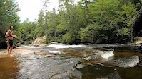
Corn Mill Shoals Trail is primarily an old forest service road from Corn Mill Shoals Access Area to the Little River (AKA Corn Mills Shoals). It is primarily single track with lots of variety, rock features and slick rock east of Little River to Bridal Veil Falls. Depending on water level, water temperature, skill level and sense of adventure, one can cross Little River to gain access to the other side of DuPont Forest. There is NO BRIDGE across Little River.

LOCALS TIP: LIttle River Bring extra socks and cross as far upstream as possible in your socks and carry your bike across. It is NOT recommended for horses to cross Little River.

Corn Mill Shoals Trail can also be accessed from other parking areas from a variety of other adjoining trails east of Little River.

Disclaimer

Use care if crossing Little River - Not recommended for equestrian crossing.

Local Trail Association

Recent Activity on Trail

Past Week
  • 4 rides
  • 11 miles average
6 Months
  • 69 rides
  • 16 miles avg distance
All
  • 520 rides
  • Last: Jun 20, 2026
c1c2c3c4
January
February
March
April
May
June
July
August
September
October
November
December
update trails status or condition

Corn Mill Shoals... Trail Reports

statusdatedescription
Feb 20, 2026 @ 5:49pm (America/New_York)
Feb 20, 2026
reporter
Feb 18, 2026 @ 11:17am (America/New_York)
Feb 18, 2026
reporter Single Track Trails OPEN
Jan 29, 2026 @ 9:14pm (America/New_York)
Jan 29, 2026
reporter Single Track Closure
Jul 17, 2025 @ 11:14am
Jul 17, 2025
reporter East of Little River: trail is in need of maintenance. Corridor clearing and drain cleaning will get this area between the river and Laurel Ridge...
Jun 23, 2025 @ 5:22pm
Jun 23, 2025
more »
Status:
on Feb 20, 2026
Variable
Avg: 3.52 (19 votes)
Your vote: 0

view (2,620)
close
3D
Trail Conditions
  • Unknown
  • Snow Groomed
  • Snow Packed
  • Snow Covered
  • Snow Cover Partial
  • Freeze/thaw Cycle
  • Icy
  • Prevalent Mud
  • Wet
  • Variable
  • Ideal
  • Dry
  • Very Dry
Trail Flow (Ridden Direction)
Trailforks scans users ridelogs to determine the most popular direction each trail is ridden. A good flowing trail network will have most trails flowing in a single direction according to their intension.
The colour categories are based on what percentage of riders are riding a trail in its intended direction.
  • > 96%
  • > 90%
  • > 80%
  • > 70%
  • > 50%
  • < 50%
  • bi-directional trail
  • no data
Trail Last Ridden
Trailforks scans ridelogs to determine the last time a trail was ridden.
  • < 2 days
  • < 1 week
  • < 2 weeks
  • < 1 month
  • < 6 months
  • > 6 months
Trail Ridden Direction
The intended direction a trail should be ridden.
  • Downhill Only
  • Downhill Primary
  • Both Directions
  • Uphill Primary
  • Uphill Only
  • One Direction
Contribute Details
Colors indicate trail is missing specified detail.
  • Description
  • Photos
  • Description & Photos
  • Videos
Trail Popularity ?
Trailforks scans ridelogs to determine which trails are ridden the most in the last 9 months. Trails are compared with nearby trails in the same city region with a possible 25 colour shades. Think of this as a heatmap, more rides = more kinetic energy = warmer colors.
  • most popular
  • popular
  • less popular
  • not popular
ATV/ORV/OHV Filter
Max Vehicle Width
inches
US Cell Coverage
Legend
cell carrier legend

Radar Time
Activity Recordings
Trailforks uses anonymized public activity data. ?
Activity Recordings
Trailforks uses anonymized public activity data. ?
Personal Heatmap
Activity Types
all / none
Options
2
Date range month
Winter Trails
Warning A routing network for winter maps does not exist. Selecting trails using the winter trails layer has been disabled.
Missing Trails
Most Popular
Least Popular
Trails are colored based on popularity. The more popular a trail is, the more red. Less popular trails trend towards green.
Jump Magnitude Heatmap
Heatmap of where riders jump on trails. Zoom in to see individual jumps, click circles to view jump details.
BC Backroad Status

Service Road Atlas is a free to use, community-driven service for viewing and creating reports on the numerous back-country service roads around B.C. and Alberta.

map legend
Slope Aspect
Direction the slope faces
Flat N NE E SE S SW W NW
Trails Deemphasized
Trails are shown in grey.
disable
Only show trails with no bike usage.
Enable
Suggested Layers
Based on selected activity type

    Save the current map location and zoom level as your default home location whenever this page is loaded.

    Save
        Directions to corn-mill-shoals-trail trailhead (35.172920, -82.638610)

        Photos

        17 more »
        60 |
        Jul 23, 2024 @ 9:19am
        Jul 23, 2024
        75 |
        Jan 15, 2024 @ 10:04am
        Jan 15, 2024
        125 |
        Apr 27, 2022 @ 4:02pm
        Apr 27, 2022
        129 |
        Aug 28, 2021 @ 2:22pm
        Aug 28, 2021

        Videos

        1 more »
        Dupont State Forest - Plan B day
        0:56 | 274 | Dec 14, 2020 , Cedar Mountain

        Trail Lists

        Routes with this trail

        4.4 25 miles 2,693 ft 22 Loop
        DuPont route that includes Big Rock and Ridgeline
        6 miles 748 ft 14
        without limits big rock ride saturday
        5.0 26 miles 3,206 ft 30
        I've never ridden this. My friends say it is the ultimate route, so I am saving it so that I can reference...

        6 Reviews & Comments


        We hope you've been enjoying Trailforks!

        Create a FREE account to view trail comments and much more.

        • By caleb93TF Pro & contributors
        • #7355 - 6,921 views

        Frequently Asked Questions About Corn Mill Shoals Trail

        Where is Corn Mill Shoals Trail located?
        Corn Mill Shoals Trail is located in Dupont State Recreational Forest, Cedar Mountain, North Carolina, United States. It is part of the Dupont State Recreational Forest trail network. The trailhead is located at coordinates 35.17292, -82.63861.
        How hard is Corn Mill Shoals Trail?
        Corn Mill Shoals Trail is rated as Blue difficulty. The physical rating is Moderate. The average grade is 1.1%. The climb difficulty is rated Blue.
        What is the elevation gain for Corn Mill Shoals Trail?
        Corn Mill Shoals Trail has 177 ft of elevation gain. The trail has 324 ft of elevation descent. The elevation ranges from 2,571 ft to 2,797 ft.
        Is Corn Mill Shoals Trail a point to point trail?
        Corn Mill Shoals Trail is not a point to point trail. The direction is Both Directions. The trail type is singletrack.

        Hit the Trail

        Open in App

        Get this trail on your phone instantly.
        open trail in app

        Download Trail

        Save to wishlist, Garmin & download.
        save the trail

        Find Related Routes

        Find routes and users activities that include this trail.
        find routes for this trail

        You must enter a description before submitting.