more stats
2,162 ft
Distance
8 ft
Climb
-302 ft
Descent
00:02:09
Avg time
-294 ft
Altitude change
520 ft
Altitude min
814 ft
Altitude max
814 ft
Altitude start
522 ft
Altitude end
-13.6%
Grade
-35.2%
Grade max
7.1%
Grade min
151 ft
Distance climb
1,991 ft
Distance down
20 ft
Distance flat
00:02:09
Avg time

Corona Lockdown (NLT 32) Details

  • Activities
    • Mountain Bike
    • E-Bike
  • Riding Area
  • Ref Number
    #32
  • Difficulty Rating
  • Local Popularity
    95 in Mountain Biking [+]
    • 90 in E-Biking
  • Global Ranking
    #2167 in Mountain Biking [+]
    • #25331 in E-Biking
  • Trail Type
    Singletrack
  • Bike Type
    AM, XC
  • Dogs Allowed
    Yes
  • eBike Allowed
  • TTFs on Trail
    Berm, Roller Coaster
  • Land Owner

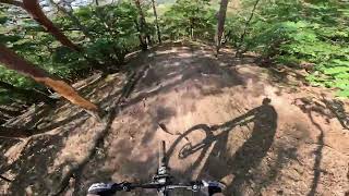
Some big wall-like berms along the ravine in the bottom part

Damit das Projekt funktioniert und langfristig bestehen bleibt, braucht es klare Regeln.

Wir bitten alle Nutzer*innen:

keine Strecken verändern – bitte nehmt keine Veränderungen an den bestehenden Trails vor.

keine Abkürzungen anlegen – sie zerstören den Streckenverlauf, führen zu Erosion und machen die Pflege aufwändiger.

keine eigenen Trails bauen – eigene Trails, Sprünge oder Abkürzungen gefährden die Genehmigung.

Kein Fahren bei starker Nässe – matschige Trails nehmen schnell Schaden und brauchen dann viel Pflege.

Kein rücksichtsloses Verhalten – wer andere Waldnutzende gefährdet oder ignoriert, gefährdet das gesamte Projekt.


Du willst dich einbringen – beim Trailbau oder mit Ideen?
Dann sprich uns an oder werde Teil unserer WhatsApp-Community. Wir freuen uns über jede helfende Hand

Recent Activity on Trail

Past Week
  • 1 rides
  • 19 miles average
6 Months
  • 16 rides
  • 14 miles avg distance
All
  • 126 rides
  • Last: Jun 12, 2026
c1c2c3c4
January
February
March
April
May
June
July
August
September
October
November
December
Status:
on May 17, 2026
Ideal
Avg: 4.45 (7 votes)
Your vote: 0

view (485)
close
3D
Trail Conditions
  • Unknown
  • Snow Groomed
  • Snow Packed
  • Snow Covered
  • Snow Cover Partial
  • Freeze/thaw Cycle
  • Icy
  • Prevalent Mud
  • Wet
  • Variable
  • Ideal
  • Dry
  • Very Dry
Trail Flow (Ridden Direction)
Trailforks scans users ridelogs to determine the most popular direction each trail is ridden. A good flowing trail network will have most trails flowing in a single direction according to their intension.
The colour categories are based on what percentage of riders are riding a trail in its intended direction.
  • > 96%
  • > 90%
  • > 80%
  • > 70%
  • > 50%
  • < 50%
  • bi-directional trail
  • no data
Trail Last Ridden
Trailforks scans ridelogs to determine the last time a trail was ridden.
  • < 2 days
  • < 1 week
  • < 2 weeks
  • < 1 month
  • < 6 months
  • > 6 months
Trail Ridden Direction
The intended direction a trail should be ridden.
  • Downhill Only
  • Downhill Primary
  • Both Directions
  • Uphill Primary
  • Uphill Only
  • One Direction
Contribute Details
Colors indicate trail is missing specified detail.
  • Description
  • Photos
  • Description & Photos
  • Videos
Trail Popularity ?
Trailforks scans ridelogs to determine which trails are ridden the most in the last 9 months. Trails are compared with nearby trails in the same city region with a possible 25 colour shades. Think of this as a heatmap, more rides = more kinetic energy = warmer colors.
  • most popular
  • popular
  • less popular
  • not popular
ATV/ORV/OHV Filter
Max Vehicle Width
inches
US Cell Coverage
Legend
cell carrier legend

Radar Time
Activity Recordings
Trailforks uses anonymized public activity data. ?
Activity Recordings
Trailforks uses anonymized public activity data. ?
Personal Heatmap
Activity Types
all / none
Options
2
Date range month
Winter Trails
Warning A routing network for winter maps does not exist. Selecting trails using the winter trails layer has been disabled.
Missing Trails
Most Popular
Least Popular
Trails are colored based on popularity. The more popular a trail is, the more red. Less popular trails trend towards green.
Jump Magnitude Heatmap
Heatmap of where riders jump on trails. Zoom in to see individual jumps, click circles to view jump details.
BC Backroad Status

Service Road Atlas is a free to use, community-driven service for viewing and creating reports on the numerous back-country service roads around B.C. and Alberta.

map legend
Slope Aspect
Direction the slope faces
Flat N NE E SE S SW W NW
Trails Deemphasized
Trails are shown in grey.
disable
Only show trails with no bike usage.
Enable
Suggested Layers
Based on selected activity type

    Save the current map location and zoom level as your default home location whenever this page is loaded.

    Save
        Directions to corona-lockdown-nlt-32 trailhead (49.793520, 7.841690)

        Photos

        No photos have been added for Corona Lockdown (NLT 32) yet, add a photo.

        Videos

        2 more »
        Kuhberg / Corona + Upper Flak : KH-Trail
        3:37 | 180 | Aug 22, 2023 , Bad Kreuznach
        Flak und Corona Lockdown Trailkombi
        3:33 | 143 | Jul 31, 2023 , Bad Kreuznach

        Links

        3 Reviews & Comments


        We hope you've been enjoying Trailforks!

        Create a FREE account to view trail comments and much more.

        • By adamschlangTF Pro & contributors
        • #428836 - 938 views

        Frequently Asked Questions About Corona Lockdown (NLT 32)

        Where is Corona Lockdown (NLT 32) located?
        Corona Lockdown (NLT 32) is located in Bad Kreuznach, Germany. It is part of the Bad Kreuznach trail network. The trailhead is located at coordinates 49.79352, 7.84169.
        How hard is Corona Lockdown (NLT 32)?
        Corona Lockdown (NLT 32) is rated as Red difficulty. The average grade is 13.6%.
        What is the elevation gain for Corona Lockdown (NLT 32)?
        Corona Lockdown (NLT 32) has 8 ft of elevation gain. The trail has 302 ft of elevation descent. The elevation ranges from 520 ft to 814 ft.
        How long is Corona Lockdown (NLT 32)?
        Corona Lockdown (NLT 32) is 2,162 ft long. The trail type is singletrack.

        Hit the Trail

        Open in App

        Get this trail on your phone instantly.
        open trail in app

        Download Trail

        Save to wishlist, Garmin & download.
        save the trail

        Find Related Routes

        Find routes and users activities that include this trail.
        find routes for this trail

        You must enter a description before submitting.