more stats
1.2 miles
Distance
39 ft
Climb
-1,405 ft
Descent
00:06:38
Avg time
-1,367 ft
Altitude change
3,952 ft
Altitude min
5,319 ft
Altitude max
5,319 ft
Altitude start
3,953 ft
Altitude end
-22.2%
Grade
-86.8%
Grade max
43.9%
Grade min
778 ft
Distance climb
3,973 ft
Distance down
1,404 ft
Distance flat
00:06:38
Avg time

Coronet DH Details

  • Activities
    • Mountain Bike
    • E-Bike
  • Riding Area
  • Difficulty Rating
  • Local Popularity
    45 in Mountain Biking [+]
    • 30 in E-Biking
  • Global Ranking
    #109052 in Mountain Biking [+]
    • #102444 in E-Biking
  • Trail Type
    Singletrack
  • Bike Type
    DH, AM
  • Direction
    Downhill Only
  • Season
    Summer
  • Dogs Allowed
    Yes
  • eBike Allowed
  • TTFs on Trail
    Berm, Drop, Jump, Gap Jump, Rock Face

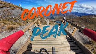
Cool DH track that can be accessed by climbing the XC track outside of operating hours or take the chairlift during summer

Access Info

Ride up the 'XC' trail to the top of the Coronet Express chair and enter the trail from the top of the Chimney ski run. Or take the chairlift during summer. Check nzski.com for info

Bike Park

Traditionally Indigenous Territory

Recent Activity on Trail

Past Week
  • 0 rides
  •  
6 Months
  • 22 rides
  • 28 miles avg distance
All
  • 68 rides
  • Last: Apr 11, 2026
c1c2c3c4
January
February
March
April
May
June
July
August
September
October
November
December
update trails status or condition

Coronet DH Trail Reports

statusdatedescription
May 31, 2026 @ 5:30pm (Pacific/Auckland)
May 30, 2026
Feb 24, 2026 @ 8:41am (Pacific/Auckland)
Feb 23, 2026
May 27, 2025 @ 10:35pm
May 27, 2025
Closed for Winter! Please keep off the trail to prevent damage. Will let you know when it's back open in spring.
Dec 11, 2024 @ 12:48pm
Dec 11, 2024
May 7, 2024 @ 10:00pm
May 7, 2024
Closed for Winter! With freeze thaw and snow the trail gets damaged really easily so please keep off the trail to prevent damage. Will let you...
more »
Status:
on May 31, 2026
Freeze/thaw Cycle
Avg: 3.66 (10 votes)
Your vote: 0

view (1,777)
close
3D
Trail Conditions
  • Unknown
  • Snow Groomed
  • Snow Packed
  • Snow Covered
  • Snow Cover Partial
  • Freeze/thaw Cycle
  • Icy
  • Prevalent Mud
  • Wet
  • Variable
  • Ideal
  • Dry
  • Very Dry
Trail Flow (Ridden Direction)
Trailforks scans users ridelogs to determine the most popular direction each trail is ridden. A good flowing trail network will have most trails flowing in a single direction according to their intension.
The colour categories are based on what percentage of riders are riding a trail in its intended direction.
  • > 96%
  • > 90%
  • > 80%
  • > 70%
  • > 50%
  • < 50%
  • bi-directional trail
  • no data
Trail Last Ridden
Trailforks scans ridelogs to determine the last time a trail was ridden.
  • < 2 days
  • < 1 week
  • < 2 weeks
  • < 1 month
  • < 6 months
  • > 6 months
Trail Ridden Direction
The intended direction a trail should be ridden.
  • Downhill Only
  • Downhill Primary
  • Both Directions
  • Uphill Primary
  • Uphill Only
  • One Direction
Contribute Details
Colors indicate trail is missing specified detail.
  • Description
  • Photos
  • Description & Photos
  • Videos
Trail Popularity ?
Trailforks scans ridelogs to determine which trails are ridden the most in the last 9 months. Trails are compared with nearby trails in the same city region with a possible 25 colour shades. Think of this as a heatmap, more rides = more kinetic energy = warmer colors.
  • most popular
  • popular
  • less popular
  • not popular
ATV/ORV/OHV Filter
Max Vehicle Width
inches
US Cell Coverage
Legend
cell carrier legend

Radar Time
Activity Recordings
Trailforks uses anonymized public activity data. ?
Activity Recordings
Trailforks uses anonymized public activity data. ?
Personal Heatmap
Activity Types
all / none
Options
2
Date range month
Winter Trails
Warning A routing network for winter maps does not exist. Selecting trails using the winter trails layer has been disabled.
Missing Trails
Most Popular
Least Popular
Trails are colored based on popularity. The more popular a trail is, the more red. Less popular trails trend towards green.
Jump Magnitude Heatmap
Heatmap of where riders jump on trails. Zoom in to see individual jumps, click circles to view jump details.
BC Backroad Status

Service Road Atlas is a free to use, community-driven service for viewing and creating reports on the numerous back-country service roads around B.C. and Alberta.

map legend
Slope Aspect
Direction the slope faces
Flat N NE E SE S SW W NW
Trails Deemphasized
Trails are shown in grey.
disable
Only show trails with no bike usage.
Enable
Suggested Layers
Based on selected activity type

    Save the current map location and zoom level as your default home location whenever this page is loaded.

    Save
        Directions to coronet-dh trailhead (-44.916340, 168.739070)

        Photos

        591 more »
        64 |
        Aug 15, 2025 @ 6:35am
        Aug 15, 2025
        44 |
        Aug 15, 2025 @ 6:36am
        Aug 15, 2025
        39 |
        Aug 15, 2025 @ 6:37am
        Aug 15, 2025
        59 |
        Jun 8, 2025 @ 6:19pm
        Jun 8, 2025

        Videos

        8 more »
        Coronet MTB Trails - Dirt Serpent | Coronet DH...
        14:59 | 62 | Mar 30, 2026 , Queenstown
        youtuber Most INSANE Moments of 2023! (Pt. 5) - 'Camp...
        10:02 | 187 | Jan 23, 2024 , Queenstown
        youtuber Most INSANE Moments of 2022! (Pt. 5) -...
        31:40 | 149 | Apr 13, 2023 , Queenstown
        youtuber Most INSANE Unseen Moments of 2022! (Pt. 2) -...
        19:59 | 153 | Feb 28, 2023 , Queenstown

        Routes with this trail

        2.0 12 miles 3,148 ft 6 Loop
        This takes a lot of the good trails on Coronet. Best done with a friend so you can leave one vehicle a the...
        22 miles 5,936 ft 11
        Big pedal loop (you can cheat and shuttle CP road) taking in all the Coronet classics as of 2021. Coronet...

        4 Reviews & Comments


        We hope you've been enjoying Trailforks!

        Create a FREE account to view trail comments and much more.

        • By red720 & contributors
        • #83110 - 5,266 views

        Frequently Asked Questions About Coronet DH

        Where is Coronet DH located?
        Coronet DH is located in Coronet Peak Ski & Mountain Bike Park, Queenstown, New Zealand. It is part of the Coronet Peak Ski & Mountain Bike Park trail network. The trailhead is located at coordinates -44.91634, 168.73907.
        How hard is Coronet DH?
        Coronet DH is rated as Black Diamond difficulty. The average grade is 22.2%.
        What is the elevation gain for Coronet DH?
        Coronet DH has 39 ft of elevation gain. The trail has 1,405 ft of elevation descent. The elevation ranges from 3,952 ft to 5,319 ft.
        Is Coronet DH a point to point trail?
        Yes, Coronet DH is a point to point trail. The direction is Downhill Only. The trail type is singletrack.

        Hit the Trail

        Open in App

        Get this trail on your phone instantly.
        open trail in app

        Download Trail

        Save to wishlist, Garmin & download.
        save the trail

        Find Related Routes

        Find routes and users activities that include this trail.
        find routes for this trail

        You must enter a description before submitting.