more stats
2.2 miles
Distance
1,357 ft
Climb
-55 ft
Descent
00:28:30
Avg time
1,302 ft
Altitude change
4,016 ft
Altitude min
5,318 ft
Altitude max
4,016 ft
Altitude start
5,318 ft
Altitude end
11.1%
Grade
-14%
Grade max
78.6%
Grade min
2 miles
Distance climb
991 ft
Distance down
525 ft
Distance flat
00:28:30
Avg time

Way Out Wide Details

  • Activities
    • Mountain Bike
    • E-Bike
  • Riding Area
  • Difficulty Rating
  • Local Popularity
    15 in Mountain Biking [+]
    • 35 in E-Biking
  • Global Ranking
    #96265 in Mountain Biking [+]
    • #97311 in E-Biking
  • Trail Type
    Singletrack
  • Bike Type
    AM, XC
  • Climb Difficulty
    Black Diamond
  • Physical Rating
    Hard
  • Season
    Summer
  • Dogs Allowed
    Yes
  • eBike Allowed
  • Year Opened
    2006
  • Land Owner
    DOC

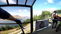
Way Out Wide is a 100% purpose built single track coming down from the top of the M1 ski run. It is both an uphill and downhill track so keep an eye out for other riders.

Access Info

From the ski field base building ride up beside the beginners 'magic carpet' singletrack entrance just beyond the start of the lift.

Trail Supporters
  • NZ Ski
    Maintainer

Bike Park

Traditionally Indigenous Territory

Recent Activity on Trail

Past Week
  • 0 rides
  •  
6 Months
  • 12 rides
  • 28 miles avg distance
All
  • 105 rides
  • Last: Mar 21, 2026
c1c2c3c4
January
February
March
April
May
June
July
August
September
October
November
December
update trails status or condition

Way Out Wide Trail Reports

statusdatedescription
May 31, 2026 @ 5:30pm (Pacific/Auckland)
May 30, 2026
Closed for Winter! Please keep off the trail to prevent damage. Will let you know when it's back open in Spring!
May 27, 2025 @ 10:38pm
May 27, 2025
Closed for Winter! Please keep off the trail to prevent damage. Will let you know when it's back open in spring.
Jan 29, 2025 @ 8:16pm
Jan 29, 2025
The riding direction on Trailforks is incorrect. This trail is in NOT to be ridden uphill!!!! EDIT: Received a message from Trailforks...
Dec 11, 2024 @ 12:48pm
Dec 11, 2024
May 7, 2024 @ 9:58pm
May 7, 2024
Closed for Winter! With freeze thaw and snow the trail gets damaged really easily so please keep off the trail to prevent damage. Will let you...
more »
Status:
on May 31, 2026
Freeze/thaw Cycle
Avg: 3.92 (10 votes)
Your vote: 0

view (1,749)
close
3D
Trail Conditions
  • Unknown
  • Snow Groomed
  • Snow Packed
  • Snow Covered
  • Snow Cover Partial
  • Freeze/thaw Cycle
  • Icy
  • Prevalent Mud
  • Wet
  • Variable
  • Ideal
  • Dry
  • Very Dry
Trail Flow (Ridden Direction)
Trailforks scans users ridelogs to determine the most popular direction each trail is ridden. A good flowing trail network will have most trails flowing in a single direction according to their intension.
The colour categories are based on what percentage of riders are riding a trail in its intended direction.
  • > 96%
  • > 90%
  • > 80%
  • > 70%
  • > 50%
  • < 50%
  • bi-directional trail
  • no data
Trail Last Ridden
Trailforks scans ridelogs to determine the last time a trail was ridden.
  • < 2 days
  • < 1 week
  • < 2 weeks
  • < 1 month
  • < 6 months
  • > 6 months
Trail Ridden Direction
The intended direction a trail should be ridden.
  • Downhill Only
  • Downhill Primary
  • Both Directions
  • Uphill Primary
  • Uphill Only
  • One Direction
Contribute Details
Colors indicate trail is missing specified detail.
  • Description
  • Photos
  • Description & Photos
  • Videos
Trail Popularity ?
Trailforks scans ridelogs to determine which trails are ridden the most in the last 9 months. Trails are compared with nearby trails in the same city region with a possible 25 colour shades. Think of this as a heatmap, more rides = more kinetic energy = warmer colors.
  • most popular
  • popular
  • less popular
  • not popular
ATV/ORV/OHV Filter
Max Vehicle Width
inches
US Cell Coverage
Legend
cell carrier legend

Radar Time
Activity Recordings
Trailforks uses anonymized public activity data. ?
Activity Recordings
Trailforks uses anonymized public activity data. ?
Personal Heatmap
Activity Types
all / none
Options
2
Date range month
Winter Trails
Warning A routing network for winter maps does not exist. Selecting trails using the winter trails layer has been disabled.
Missing Trails
Most Popular
Least Popular
Trails are colored based on popularity. The more popular a trail is, the more red. Less popular trails trend towards green.
Jump Magnitude Heatmap
Heatmap of where riders jump on trails. Zoom in to see individual jumps, click circles to view jump details.
BC Backroad Status

Service Road Atlas is a free to use, community-driven service for viewing and creating reports on the numerous back-country service roads around B.C. and Alberta.

map legend
Slope Aspect
Direction the slope faces
Flat N NE E SE S SW W NW
Trails Deemphasized
Trails are shown in grey.
disable
Only show trails with no bike usage.
Enable
Suggested Layers
Based on selected activity type

    Save the current map location and zoom level as your default home location whenever this page is loaded.

    Save
        Directions to way-out-wide trailhead (-44.926410, 168.740760)

        Photos

        78 more »
        33 |
        Mar 30, 2024 @ 11:46pm
        Mar 30, 2024
        414 |
        Dec 15, 2021 @ 11:29pm
        Dec 15, 2021
        149 |
        Mar 8, 2020 @ 7:19pm
        Mar 8, 2020
        105 |
        Mar 8, 2020 @ 7:19pm
        Mar 8, 2020

        Videos

        5 more »
        youtuber Way Out Wide @ Coronet Peak, Queenstown
        10:06 | 10 | Jun 14, 2026 , Queenstown
        youtuber Coronet Peak call this an 'XC Trail'? Not behd.
        8:00 | 493 | Mar 1, 2023 , Queenstown
        Legendary Coronet XC full track | Bike Travel...
        9:56 | 1252 | Jul 29, 2019 , Queenstown
        YTB in NZ
        6:13 | 881 | Feb 6, 2017 , Queenstown

        Routes with this trail

        4.7 6 miles 176 ft 3 Point to Point
        A really good descent with being the highlight. Ride up the XC track to the top of Coronet then ride all...
        2.0 12 miles 3,148 ft 6 Loop
        This takes a lot of the good trails on Coronet. Best done with a friend so you can leave one vehicle a the...
        22 miles 5,936 ft 11
        Big pedal loop (you can cheat and shuttle CP road) taking in all the Coronet classics as of 2021. Coronet...

        4 Reviews & Comments


        We hope you've been enjoying Trailforks!

        Create a FREE account to view trail comments and much more.

        • By BrendhanTF Pro QMTBC & contributors
        • #44844 - 7,810 views

        Frequently Asked Questions About Way Out Wide

        Where is Way Out Wide located?
        Way Out Wide is located in Coronet Peak Ski & Mountain Bike Park, Queenstown, New Zealand. It is part of the Coronet Peak Ski & Mountain Bike Park trail network. The trailhead is located at coordinates -44.92641, 168.74076.
        How hard is Way Out Wide?
        Way Out Wide is rated as Blue difficulty. The physical rating is Hard. The average grade is 11.1%. The climb difficulty is rated Black Diamond.
        What is the elevation gain for Way Out Wide?
        Way Out Wide has 1,357 ft of elevation gain. The trail has 55 ft of elevation descent. The elevation ranges from 4,016 ft to 5,318 ft.
        How long is Way Out Wide?
        Way Out Wide is 2.2 miles long. The trail type is singletrack.

        Hit the Trail

        Open in App

        Get this trail on your phone instantly.
        open trail in app

        Download Trail

        Save to wishlist, Garmin & download.
        save the trail

        Find Related Routes

        Find routes and users activities that include this trail.
        find routes for this trail

        You must enter a description before submitting.