more stats
1.4 miles
Distance
15 ft
Climb
-381 ft
Descent
00:07:28
Avg time
-366 ft
Altitude change
6,391 ft
Altitude min
6,757 ft
Altitude max
6,757 ft
Altitude start
6,391 ft
Altitude end
-5.1%
Grade
-35%
Grade max
9.8%
Grade min
646 ft
Distance climb
1 mile
Distance down
719 ft
Distance flat
00:07:28
Avg time

Corral Trail (Lower) Details

  • Activities
    • Mountain Bike
    • E-Bike
    • Adaptive Bike
    • Horse
    • Hike
    • Trail Running
    • Dirtbike/Moto
    • Observed Trials
    • ATV/ORV/OHV
  • Riding Area
    Corral
    South Lake Tahoe, California
  • Ref Number
    #18E14
  • Difficulty Rating
  • Local Popularity
    100 in Mountain Biking [+]
    • 100 in E-Biking
    • 85 in Trail Running
    • 85 in Hiking
    • 100 in Dirtbiking
    • 5 in ATVing/Offroading
    • 5 in Horseback
    • 5 in Observed Trials
  • Global Ranking
    #1331 in Mountain Biking [+]
    • #1783 in E-Biking
    • #462 in Trail Running
    • #1373 in Hiking
    • #199 in Dirtbiking
    • #132 in ATVing/Offroading
    • #807 in Horseback
  • Hiking SAC Scale
    T1 Hiking
  • Trail Type
    Singletrack
  • Bike Type
    DH, AM, XC, Adaptive MTB
  • Direction
    Downhill Primary
    Popular Direction Shown
  • Climb Difficulty
    Blue
  • Physical Rating
    Moderate
  • Trail Visibility
    Always easy to follow
  • Season
    May-November
  • Family Friendly
    Yes
  • Dogs Allowed
    Yes
  • eBike Allowed
  • TTFs on Trail
    Berm, Drop, Jump, Gap Jump, Pump Track
  • Vehicle Info
  • Max Width
    50 inches
  • License
    Not Required

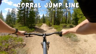
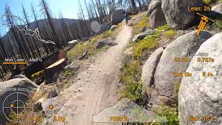
With a slew of berms, rollers, hips, and table top jumps, Lower Corral Trail has been a signature project built by TAMBA in partnership with the Forest Service since 2014. The first build was in 2014 with subsequent builds in 2015 and 2017. Out here you will find the most legal features including log rides, jumps and rock rolls in South Tahoe including the new jumps, berms, rollers and hips. Please donate if you want to see more

This is a motorized trail, so you might see dirt bikes and ebike out here. But the trail is primary downhill, uphill travel is not recommended. Ride up Cedar or the paved Fountain Place Road to loop it.

Trail Supporters
Local Trail Association
Traditionally Indigenous Territory

Recent Activity on Trail

Past Week
  • 33 rides
  • 14 miles average
6 Months
  • 382 rides
  • 12 miles avg distance
All
  • 2,650 rides
  • Last: Jun 19, 2026
c1c2c3c4
January
February
March
April
May
June
July
August
September
October
November
December
Status:
on May 22, 2026
Very Dry
Avg: 4.79 (57 votes)
Your vote: 0

view (16,462)
close
3D
Trail Conditions
  • Unknown
  • Snow Groomed
  • Snow Packed
  • Snow Covered
  • Snow Cover Partial
  • Freeze/thaw Cycle
  • Icy
  • Prevalent Mud
  • Wet
  • Variable
  • Ideal
  • Dry
  • Very Dry
Trail Flow (Ridden Direction)
Trailforks scans users ridelogs to determine the most popular direction each trail is ridden. A good flowing trail network will have most trails flowing in a single direction according to their intension.
The colour categories are based on what percentage of riders are riding a trail in its intended direction.
  • > 96%
  • > 90%
  • > 80%
  • > 70%
  • > 50%
  • < 50%
  • bi-directional trail
  • no data
Trail Last Ridden
Trailforks scans ridelogs to determine the last time a trail was ridden.
  • < 2 days
  • < 1 week
  • < 2 weeks
  • < 1 month
  • < 6 months
  • > 6 months
Trail Ridden Direction
The intended direction a trail should be ridden.
  • Downhill Only
  • Downhill Primary
  • Both Directions
  • Uphill Primary
  • Uphill Only
  • One Direction
Contribute Details
Colors indicate trail is missing specified detail.
  • Description
  • Photos
  • Description & Photos
  • Videos
Trail Popularity ?
Trailforks scans ridelogs to determine which trails are ridden the most in the last 9 months. Trails are compared with nearby trails in the same city region with a possible 25 colour shades. Think of this as a heatmap, more rides = more kinetic energy = warmer colors.
  • most popular
  • popular
  • less popular
  • not popular
ATV/ORV/OHV Filter
Max Vehicle Width
inches
US Cell Coverage
Legend
cell carrier legend

Radar Time
Activity Recordings
Trailforks uses anonymized public activity data. ?
Activity Recordings
Trailforks uses anonymized public activity data. ?
Personal Heatmap
Activity Types
all / none
Options
2
Date range month
Winter Trails
Warning A routing network for winter maps does not exist. Selecting trails using the winter trails layer has been disabled.
Missing Trails
Most Popular
Least Popular
Trails are colored based on popularity. The more popular a trail is, the more red. Less popular trails trend towards green.
Jump Magnitude Heatmap
Heatmap of where riders jump on trails. Zoom in to see individual jumps, click circles to view jump details.
BC Backroad Status

Service Road Atlas is a free to use, community-driven service for viewing and creating reports on the numerous back-country service roads around B.C. and Alberta.

map legend
Slope Aspect
Direction the slope faces
Flat N NE E SE S SW W NW
Trails Deemphasized
Trails are shown in grey.
disable
Only show trails with no bike usage.
Enable
Suggested Layers
Based on selected activity type

    Save the current map location and zoom level as your default home location whenever this page is loaded.

    Save
        Directions to corral-trail-lower trailhead (38.870480, -119.963320)

        Photos

        79 more »
        201 |
        Jun 17, 2020 @ 10:04am
        Jun 17, 2020
        233 |
        Sep 12, 2020 @ 5:20pm
        Sep 12, 2020
        133 |
        Sep 12, 2020 @ 5:09pm
        Sep 12, 2020
        307 |
        Sep 12, 2020 @ 5:10pm
        Sep 12, 2020

        Videos

        15 more »
        youtuber Corral Jump Line / South Lake Tahoe, CA / MTB
        2:14 | 165 | May 31, 2025 , South Lake Tahoe
        Corral - Lake Tahoe (10/13/2024)
        4:15 | 95 | Oct 17, 2024 , South Lake Tahoe
        CORRAL TRAIL : WHAT TO EXPECT - SOUTH LAKE...
        8:06 | 330 | Oct 6, 2022 , South Lake Tahoe
        Lower Corral Trail with Francesca, South Lake...
        3:31 | 293 | Sep 9, 2022 , South Lake Tahoe

        Routes with this trail

        33 miles 4,569 ft 11 Loop
        A more challenging technical approach to Heavenly TRT. Ride up the scenic Van Sickle trail, into Heavenly....
        8 miles 1,395 ft 5 Loop
        A really good climb on paved fire road followed by about four miles of super fun downhill, with fantastic...
        9 miles 1,506 ft 4 Loop
        Nice challenging fire road climb followed by downhill sections on some Tahoe classics. Loop originally...

        Trail Events

        15 Reviews & Comments


        We hope you've been enjoying Trailforks!

        Create a FREE account to view trail comments and much more.

        • By TheAngryTomatoTF Pro TRAILFORKS & contributors
        • #23957 - 21,365 views

        Frequently Asked Questions About Corral Trail (Lower)

        Where is Corral Trail (Lower) located?
        Corral Trail (Lower) is located in Corral, South Lake Tahoe, California, United States. It is part of the Corral trail network. The trailhead is located at coordinates 38.87048, -119.96332.
        How hard is Corral Trail (Lower)?
        Corral Trail (Lower) is rated as Blue difficulty. The physical rating is Moderate. The average grade is 5.1%. The climb difficulty is rated Blue.
        What is the elevation gain for Corral Trail (Lower)?
        Corral Trail (Lower) has 15 ft of elevation gain. The trail has 381 ft of elevation descent. The elevation ranges from 6,391 ft to 6,757 ft.
        Is Corral Trail (Lower) a point to point trail?
        Corral Trail (Lower) is not a point to point trail. The direction is Downhill Primary. The trail type is singletrack.

        Hit the Trail

        Open in App

        Get this trail on your phone instantly.
        open trail in app

        Download Trail

        Save to wishlist, Garmin & download.
        save the trail

        Find Related Routes

        Find routes and users activities that include this trail.
        find routes for this trail

        You must enter a description before submitting.