more stats
3,563 ft
Distance
-283 ft
Descent
00:04:05
Avg time
-284 ft
Altitude change
6,759 ft
Altitude min
7,043 ft
Altitude max
7,043 ft
Altitude start
6,759 ft
Altitude end
-8%
Grade
-30.5%
Grade max
4.1%
Grade min
89 ft
Distance climb
3,258 ft
Distance down
177 ft
Distance flat
00:04:05
Avg time

Corral Trail (Upper) Details

  • Activities
    • Mountain Bike
    • E-Bike
    • Adaptive Bike
    • Horse
    • Hike
    • Trail Running
    • Dirtbike/Moto
    • Observed Trials
    • ATV/ORV/OHV
  • Riding Area
    Corral
    South Lake Tahoe, California
  • Ref Number
    #18E14
  • Difficulty Rating
  • Local Popularity
    100 in Mountain Biking [+]
    • 95 in E-Biking
    • 90 in Trail Running
    • 75 in Hiking
    • 85 in Dirtbiking
    • 5 in ATVing/Offroading
    • 5 in Horseback
    • 5 in Observed Trials
  • Global Ranking
    #5532 in Mountain Biking [+]
    • #2057 in E-Biking
    • #1148 in Trail Running
    • #2129 in Hiking
    • #3098 in Dirtbiking
    • #134 in ATVing/Offroading
    • #868 in Horseback
  • Hiking SAC Scale
    T2 Mountain Hiking
  • Trail Type
    Singletrack
  • Bike Type
    DH, AM, XC, Adaptive MTB
  • Direction
    Downhill Primary
  • Climb Difficulty
    Black Diamond
  • Physical Rating
    Moderate
  • Trail Visibility
    Always easy to follow
  • Season
    May-November
  • Dogs Allowed
    Yes
  • eBike Allowed
  • TTFs on Trail
    Berm, Drop, Jump, Rock Garden
  • Vehicle Info
  • Max Width
    50 inches

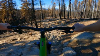
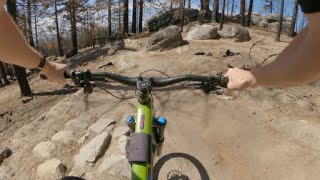
Upper Corral is a rough rocky trail with tight banked turns and many optional jumps and drops.

Access Info

Upper Corral is primarily accessed from the paved parking area at the 2 mile marker up Fountain Place Rd (which is the continuation of Oneidas St.). 300 ft from the upper trailhead Sidewinder takes off to the right. The terminus off Upper Corral is at the bridge and creek crossing where Lower Corral picks up.

Trail Supporters
Local Trail Association
Traditionally Indigenous Territory

Recent Activity on Trail

Past Week
  • 22 rides
  • 15 miles average
6 Months
  • 324 rides
  • 12 miles avg distance
All
  • 2,139 rides
  • Last: Jun 18, 2026
c1c2c3c4
January
February
March
April
May
June
July
August
September
October
November
December
update trails status or condition

Corral Trail (Upper) Trail Reports

Status:
on May 22, 2026
Very Dry
Avg: 4.77 (46 votes)
Your vote: 0

view (15,656)
close
3D
Trail Conditions
  • Unknown
  • Snow Groomed
  • Snow Packed
  • Snow Covered
  • Snow Cover Partial
  • Freeze/thaw Cycle
  • Icy
  • Prevalent Mud
  • Wet
  • Variable
  • Ideal
  • Dry
  • Very Dry
Trail Flow (Ridden Direction)
Trailforks scans users ridelogs to determine the most popular direction each trail is ridden. A good flowing trail network will have most trails flowing in a single direction according to their intension.
The colour categories are based on what percentage of riders are riding a trail in its intended direction.
  • > 96%
  • > 90%
  • > 80%
  • > 70%
  • > 50%
  • < 50%
  • bi-directional trail
  • no data
Trail Last Ridden
Trailforks scans ridelogs to determine the last time a trail was ridden.
  • < 2 days
  • < 1 week
  • < 2 weeks
  • < 1 month
  • < 6 months
  • > 6 months
Trail Ridden Direction
The intended direction a trail should be ridden.
  • Downhill Only
  • Downhill Primary
  • Both Directions
  • Uphill Primary
  • Uphill Only
  • One Direction
Contribute Details
Colors indicate trail is missing specified detail.
  • Description
  • Photos
  • Description & Photos
  • Videos
Trail Popularity ?
Trailforks scans ridelogs to determine which trails are ridden the most in the last 9 months. Trails are compared with nearby trails in the same city region with a possible 25 colour shades. Think of this as a heatmap, more rides = more kinetic energy = warmer colors.
  • most popular
  • popular
  • less popular
  • not popular
ATV/ORV/OHV Filter
Max Vehicle Width
inches
US Cell Coverage
Legend
cell carrier legend

Radar Time
Activity Recordings
Trailforks uses anonymized public activity data. ?
Activity Recordings
Trailforks uses anonymized public activity data. ?
Personal Heatmap
Activity Types
all / none
Options
2
Date range month
Winter Trails
Warning A routing network for winter maps does not exist. Selecting trails using the winter trails layer has been disabled.
Missing Trails
Most Popular
Least Popular
Trails are colored based on popularity. The more popular a trail is, the more red. Less popular trails trend towards green.
Jump Magnitude Heatmap
Heatmap of where riders jump on trails. Zoom in to see individual jumps, click circles to view jump details.
BC Backroad Status

Service Road Atlas is a free to use, community-driven service for viewing and creating reports on the numerous back-country service roads around B.C. and Alberta.

map legend
Slope Aspect
Direction the slope faces
Flat N NE E SE S SW W NW
Trails Deemphasized
Trails are shown in grey.
disable
Only show trails with no bike usage.
Enable
Suggested Layers
Based on selected activity type

    Save the current map location and zoom level as your default home location whenever this page is loaded.

    Save
        Directions to corral-trail-upper trailhead (38.866360, -119.957950)

        Photos

        16 more »
        173 |
        May 18, 2023 @ 5:22pm
        May 18, 2023
        234 |
        May 31, 2022 @ 10:48am
        May 31, 2022
        221 |
        Oct 10, 2020 @ 4:46pm
        Oct 10, 2020
        367 |
        Dec 1, 2017 @ 6:34pm
        Dec 1, 2017

        Videos

        18 more »
        youtuber Bonus Content: Trail Preview - Corral Trail
        8:12 | 307 | May 22, 2024 , South Lake Tahoe
        youtuber Corral Trail | South Lake Tahoe Mountain Biking
        6:17 | 1240 | Jan 23, 2019 , South Lake Tahoe
        youtuber Corral (post-Caldor Fire) / South Lake Tahoe /...
        6:02 | 56 | Nov 27, 2021 , South Lake Tahoe
        youtuber MTB Ride Log #5 (Corral Trail) / South Lake...
        7:25 | 48 | Apr 15, 2022 , South Lake Tahoe

        Routes with this trail

        5.0 5 miles 755 ft 2 Loop
        Climb up to the top of Upper Corral. This descends Upper and Lower Corral. Easier option is to descend...
        2.8 25 miles 4,762 ft 25 Loop
        The Tahoe Mountain Bike Festival’s signature ride starts with a “Triple Crown Ride” covering 30+...
        5.0 20 miles 3,355 ft 11 Loop

        7 Reviews & Comments


        We hope you've been enjoying Trailforks!

        Create a FREE account to view trail comments and much more.

        • By TheAngryTomatoTF Pro TRAILFORKS & contributors
        • #23958 - 18,821 views

        Frequently Asked Questions About Corral Trail (Upper)

        Where is Corral Trail (Upper) located?
        Corral Trail (Upper) is located in Corral, South Lake Tahoe, California, United States. It is part of the Corral trail network. The trailhead is located at coordinates 38.86636, -119.95795.
        How hard is Corral Trail (Upper)?
        Corral Trail (Upper) is rated as Black Diamond difficulty. The physical rating is Moderate. The average grade is 8%. The climb difficulty is rated Black Diamond.
        What is the elevation gain for Corral Trail (Upper)?
        The trail has 283 ft of elevation descent. The elevation ranges from 6,759 ft to 7,043 ft.
        Is Corral Trail (Upper) a point to point trail?
        Corral Trail (Upper) is not a point to point trail. The direction is Downhill Primary. The trail type is singletrack.

        Hit the Trail

        Open in App

        Get this trail on your phone instantly.
        open trail in app

        Download Trail

        Save to wishlist, Garmin & download.
        save the trail

        Find Related Routes

        Find routes and users activities that include this trail.
        find routes for this trail

        You must enter a description before submitting.