more stats
5.5 miles
Distance
807 ft
Climb
-2,619 ft
Descent
01:35:19
Avg time
-1,813 ft
Altitude change
4,996 ft
Altitude min
7,161 ft
Altitude max
6,809 ft
Altitude start
4,997 ft
Altitude end
-6.3%
Grade
-52.7%
Grade max
43.4%
Grade min
2 miles
Distance climb
4 miles
Distance down
400 ft
Distance flat
01:35:19
Avg time

Cox Hill Trail Details

  • Activities
    • Mountain Bike
    • E-Bike
    • Hike
    • Trail Running
  • Riding Area
    Jumpingpound Ridge
    Kananaskis Village, Alberta
  • Difficulty Rating
  • Voted Difficulty
    Black Diamond (2 votes)
  • Local Popularity
    100 in Mountain Biking [+]
    • 100 in E-Biking
    • 100 in Trail Running
    • 5 in Hiking
  • Global Ranking
    #14264 in Mountain Biking [+]
    • #9676 in E-Biking
    • #454 in Trail Running
    • #121405 in Hiking
  • Trail Type
    Singletrack
  • Bike Type
    AM, XC, Fat
  • Direction
    Downhill Primary
    Popular Direction Shown
  • Climb Difficulty
    Black Diamond
  • Physical Rating
    Hard
  • Dogs Allowed
    Yes
  • eBike Allowed
    Yes up to Class 1
  • TTFs on Trail
    Rock Garden
  • Land Owner
    Alberta Environment and Parks

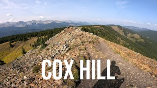
Coming off the Ridge trail, Cox tips down in a fast, flowing descent before abruptly pointing back up. Once you're over the summit, it's a looooong way down to connect with Tom Snow. The main descent is very rough and eroded, with loads of root steps and sometimes a runoff stream. You will sometimes encounter hikers coming up the main descent, so keep your eyes open.

Access Info

Connects to Tom Snow at the north end [head west on TS to get to Dawson]. At the south end, there's a junction with the Jumping Pound Ridge Trail.

Recent Activity on Trail

Past Week
  • 0 rides
  •  
6 Months
  • 2 rides
  • 37.6 km avg distance
All
  • 292 rides
  • Last: Jun 23, 2026
c1c2c3c4
January
February
March
April
May
June
July
August
September
October
November
December
update trails status or condition

Cox Hill Trail Trail Reports

statusdatedescription
Aug 23, 2025 @ 9:32am
Aug 23, 2025
Aug 9, 2025 @ 10:08pm
Aug 9, 2025
Jun 14, 2025 @ 10:45am
Jun 14, 2025
No snow left on the trail now.
May 28, 2025 @ 7:38pm
May 28, 2025
Snow covered at the top of the DH, then some mud but clean and clear 1km into the DH
Oct 19, 2024 @ 12:02pm
Oct 19, 2024
Tree down near the bottom of the trail, about 2 switchbacks up from the bottom, very large spruce, at least 30 cm in diameter.
more »
Status:
on Aug 23, 2025
Ideal
Avg: 4.22 (25 votes)
Your vote: 0

view (2,201)
close
3D
Trail Conditions
  • Unknown
  • Snow Groomed
  • Snow Packed
  • Snow Covered
  • Snow Cover Partial
  • Freeze/thaw Cycle
  • Icy
  • Prevalent Mud
  • Wet
  • Variable
  • Ideal
  • Dry
  • Very Dry
Trail Flow (Ridden Direction)
Trailforks scans users ridelogs to determine the most popular direction each trail is ridden. A good flowing trail network will have most trails flowing in a single direction according to their intension.
The colour categories are based on what percentage of riders are riding a trail in its intended direction.
  • > 96%
  • > 90%
  • > 80%
  • > 70%
  • > 50%
  • < 50%
  • bi-directional trail
  • no data
Trail Last Ridden
Trailforks scans ridelogs to determine the last time a trail was ridden.
  • < 2 days
  • < 1 week
  • < 2 weeks
  • < 1 month
  • < 6 months
  • > 6 months
Trail Ridden Direction
The intended direction a trail should be ridden.
  • Downhill Only
  • Downhill Primary
  • Both Directions
  • Uphill Primary
  • Uphill Only
  • One Direction
Contribute Details
Colors indicate trail is missing specified detail.
  • Description
  • Photos
  • Description & Photos
  • Videos
Trail Popularity ?
Trailforks scans ridelogs to determine which trails are ridden the most in the last 9 months. Trails are compared with nearby trails in the same city region with a possible 25 colour shades. Think of this as a heatmap, more rides = more kinetic energy = warmer colors.
  • most popular
  • popular
  • less popular
  • not popular
ATV/ORV/OHV Filter
Max Vehicle Width
inches
US Cell Coverage
Legend
cell carrier legend

Radar Time
Activity Recordings
Trailforks uses anonymized public activity data. ?
Activity Recordings
Trailforks uses anonymized public activity data. ?
Personal Heatmap
Activity Types
all / none
Options
2
Date range month
Winter Trails
Warning A routing network for winter maps does not exist. Selecting trails using the winter trails layer has been disabled.
Missing Trails
Most Popular
Least Popular
Trails are colored based on popularity. The more popular a trail is, the more red. Less popular trails trend towards green.
Jump Magnitude Heatmap
Heatmap of where riders jump on trails. Zoom in to see individual jumps, click circles to view jump details.
BC Backroad Status

Service Road Atlas is a free to use, community-driven service for viewing and creating reports on the numerous back-country service roads around B.C. and Alberta.

map legend
Slope Aspect
Direction the slope faces
Flat N NE E SE S SW W NW
Trails Deemphasized
Trails are shown in grey.
disable
Only show trails with no bike usage.
Enable
Suggested Layers
Based on selected activity type

    Save the current map location and zoom level as your default home location whenever this page is loaded.

    Save
        Directions to cox-hill-trail trailhead (50.974320, -114.926460)

        Photos

        79 more »
        49 |
        Sep 17, 2025 @ 4:35pm
        Sep 17, 2025
        54 |
        Sep 11, 2025 @ 10:21am
        Sep 11, 2025
        42 |
        Sep 11, 2025 @ 10:21am
        Sep 11, 2025
        59 |
        Aug 11, 2025 @ 7:07pm
        Aug 11, 2025

        Videos

        15 more »
        Cox Hill Elites | Mountain Biking video
        3:15 | 122 | Sep 15, 2025 , Kananaskis Village
        Cox Hill Trail - The Uphill was brutal,...
        32:59 | 114 | Sep 1, 2025 , Kananaskis Village
        Jumping Pound to Cox Hill // Sibbald, Alberta
        23:29 | 434 | Sep 5, 2023 , Kananaskis Village
        Cox Hill Trail | Sibbald MTB
        16:04 | 445 | Aug 7, 2022 , Kananaskis Village

        Trail Lists

        Routes with this trail

        4.5 9 miles 1,988 ft 6 Point to Point
        Tough climb with a very rewarding downhill. We tend leave a vehicle on the north end at the parking lot...
        5.0 21 miles 3,534 ft 2 Loop
        A big day out. Kilometers of riding along ridgelines in the alpine. End the day with an epic descent back...
        4.0 18 miles 3,197 ft 8 Loop
        Somewhat civilized, but definitely not an easy loop. This route has fewer hikers on the climb up to the ridge.

        8 Reviews & Comments


        We hope you've been enjoying Trailforks!

        Create a FREE account to view trail comments and much more.

        • By pinkrobe & contributors
        • #78179 - 26,292 views

        Frequently Asked Questions About Cox Hill Trail

        Where is Cox Hill Trail located?
        Cox Hill Trail is located in Jumpingpound Ridge, Kananaskis Village, Alberta, Canada. It is part of the Jumpingpound Ridge trail network. The trailhead is located at coordinates 50.97432, -114.92646.
        How hard is Cox Hill Trail?
        Cox Hill Trail is rated as Black Diamond difficulty. The physical rating is Hard. The average grade is 6.3%. The climb difficulty is rated Black Diamond.
        What is the elevation gain for Cox Hill Trail?
        Cox Hill Trail has 246 m of elevation gain. The trail has 798 m of elevation descent. The elevation ranges from 1,523 m to 2,183 m.
        Is Cox Hill Trail a point to point trail?
        Cox Hill Trail is not a point to point trail. The direction is Downhill Primary. The trail type is singletrack.

        Hit the Trail

        Open in App

        Get this trail on your phone instantly.
        open trail in app

        Download Trail

        Save to wishlist, Garmin & download.
        save the trail

        Find Related Routes

        Find routes and users activities that include this trail.
        find routes for this trail

        You must enter a description before submitting.