more stats
1.1 miles
Distance
255 ft
Climb
-103 ft
Descent
00:10:14
Avg time
152 ft
Altitude change
4,781 ft
Altitude min
4,957 ft
Altitude max
4,805 ft
Altitude start
4,957 ft
Altitude end
2.679%
Grade
-39.037%
Grade max
47.377%
Grade min
3,883 ft
Distance climb
1,423 ft
Distance down
306 ft
Distance flat
00:10:14
Avg time

Coyote Ridge Details

  • Activities
    • Mountain Bike
    • Hike
    • Trail Running
  • Riding Area
    Lunch Loops
    Grand Junction, Colorado
  • Difficulty Rating
  • Voted Difficulty
    Blue (1 vote)
  • Local Popularity
    100 in Mountain Biking [+]
    • 95 in Trail Running
    • 80 in Hiking
  • Global Ranking
    #34307 in Mountain Biking [+]
    • #40912 in Trail Running
    • #69501 in Hiking
  • Trail Type
    Singletrack
  • Direction
    Downhill Primary
  • Dogs Allowed
    Yes
  • eBike Allowed
  • Land Owner
    Grand Junction Field Office of the BLM

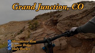
Coyote Ridge is a challenging connector with a little flow and many excellent drops and jumps (when ridden west-east). Ridden the other directions it's a technical climb that will test your riding ability. Short but sweet, it's a fun connector/cutoff route.

Trail Supporters
  • BLM
    BLM
    Land Manager
Local Trail Association
Traditionally Indigenous Territory

Recent Activity on Trail

Past Week
  • 2 rides
  • 13 miles average
6 Months
  • 195 rides
  • 12 miles avg distance
All
  • 1,409 rides
  • Last: Jun 28, 2026
c1c2c3c4
January
February
March
April
May
June
July
August
September
October
November
December
Status:
on Feb 26, 2026
Dry
Avg: 3.82 (11 votes)
Your vote: 0

view (9,626)
close
3D
Trail Conditions
  • Unknown
  • Snow Groomed
  • Snow Packed
  • Snow Covered
  • Snow Cover Partial
  • Freeze/thaw Cycle
  • Icy
  • Prevalent Mud
  • Wet
  • Variable
  • Ideal
  • Dry
  • Very Dry
Trail Flow (Ridden Direction)
Trailforks scans users ridelogs to determine the most popular direction each trail is ridden. A good flowing trail network will have most trails flowing in a single direction according to their intension.
The colour categories are based on what percentage of riders are riding a trail in its intended direction.
  • > 96%
  • > 90%
  • > 80%
  • > 70%
  • > 50%
  • < 50%
  • bi-directional trail
  • no data
Trail Last Ridden
Trailforks scans ridelogs to determine the last time a trail was ridden.
  • < 2 days
  • < 1 week
  • < 2 weeks
  • < 1 month
  • < 6 months
  • > 6 months
Trail Ridden Direction
The intended direction a trail should be ridden.
  • Downhill Only
  • Downhill Primary
  • Both Directions
  • Uphill Primary
  • Uphill Only
  • One Direction
Contribute Details
Colors indicate trail is missing specified detail.
  • Description
  • Photos
  • Description & Photos
  • Videos
Trail Popularity ?
Trailforks scans ridelogs to determine which trails are ridden the most in the last 9 months. Trails are compared with nearby trails in the same city region with a possible 25 colour shades. Think of this as a heatmap, more rides = more kinetic energy = warmer colors.
  • most popular
  • popular
  • less popular
  • not popular
ATV/ORV/OHV Filter
Max Vehicle Width
inches
US Cell Coverage
Legend
cell carrier legend

Radar Time
Activity Recordings
Trailforks uses anonymized public activity data. ?
Activity Recordings
Trailforks uses anonymized public activity data. ?
Personal Heatmap
Activity Types
all / none
Options
2
Date range month
Winter Trails
Warning A routing network for winter maps does not exist. Selecting trails using the winter trails layer has been disabled.
Missing Trails
Most Popular
Least Popular
Trails are colored based on popularity. The more popular a trail is, the more red. Less popular trails trend towards green.
Jump Magnitude Heatmap
Heatmap of where riders jump on trails. Zoom in to see individual jumps, click circles to view jump details.
BC Backroad Status

Service Road Atlas is a free to use, community-driven service for viewing and creating reports on the numerous back-country service roads around B.C. and Alberta.

map legend
Slope Aspect
Direction the slope faces
Flat N NE E SE S SW W NW
Trails Deemphasized
Trails are shown in grey.
disable
Only show trails with no bike usage.
Enable
Suggested Layers
Based on selected activity type

    Save the current map location and zoom level as your default home location whenever this page is loaded.

    Save
        Directions to coyote-ridge trailhead (39.036970, -108.596330)

        Photos

        2 more »
        81 |
        Jun 30, 2024 @ 10:00am
        Jun 30, 2024
        526 |
        Feb 3, 2015 @ 6:52am
        Feb 3, 2015

        Videos

        1 more »
        youtuber Miramonte Rim and Coyote Ridge
        15:51 | 66 | Jun 27, 2025 , Grand Junction

        Routes with this trail

        7 miles 924 ft 5
        A lunch loops classic! is a unique technically and aerobically challenging trail that is full of obstacles...
        3.0 13 miles 1,561 ft 15 Loop
        Shuttle without a vehicle. Ride up the gut on Tabeguache, then hit all of and come back down Lunch Loops...
        11 miles 1,486 ft 8
        Colorado, Grand Junction, Lunch Loops Relive Your Rides. Start your ride at the parking lot off Monument...

        Reviews / Comments

        No reviews yet, be the first to write a review or ask a question.
        Use trail reports to comment on trail conditions.


        We hope you've been enjoying Trailforks!

        Create a FREE account to view trail comments and much more.

        Nearby Trails

        • By toddTF Pro Trailforks & contributors
        • #12148 - 2,394 views

        Frequently Asked Questions About Coyote Ridge

        Where is Coyote Ridge located?
        Coyote Ridge is located in Lunch Loops, Grand Junction, Colorado, United States. It is part of the Lunch Loops trail network. The trailhead is located at coordinates 39.03697, -108.59633.
        How hard is Coyote Ridge?
        Coyote Ridge is rated as Blue difficulty. The average grade is 2.679%.
        What is the elevation gain for Coyote Ridge?
        Coyote Ridge has 78 m of elevation gain. The trail has 32 m of elevation descent. The elevation ranges from 1,457 m to 1,511 m.
        Is Coyote Ridge a point to point trail?
        Coyote Ridge is not a point to point trail. The direction is Downhill Primary. The trail type is singletrack.

        Hit the Trail

        Open in App

        Get this trail on your phone instantly.
        open trail in app

        Download Trail

        Save to wishlist, Garmin & download.
        save the trail

        Find Related Routes

        Find routes and users activities that include this trail.
        find routes for this trail

        You must enter a description before submitting.