more stats
1,483 ft
Distance
-196 ft
Descent
00:01:49
Avg time
-196 ft
Altitude change
2,931 ft
Altitude min
3,127 ft
Altitude max
3,127 ft
Altitude start
2,930 ft
Altitude end
-13.2%
Grade
-36.8%
Grade max
-3.4%
Grade min
1,483 ft
Distance down
00:01:49
Avg time

Crabapple Hits Details

  • Activities
    • Mountain Bike
  • Riding Area
    Whistler Mountain Bike Park
    Whistler, British Columbia
  • Difficulty Rating
  • Voted Difficulty
    Double Black Diamond (18 votes)
  • Local Popularity
    75 in Mountain Biking
  • Global Ranking
    #3487 in Mountain Biking
  • Trail Type
    Singletrack
  • Bike Type
    DH
  • TTFs on Trail
    Jump, Gap Jump
  • Land Owner

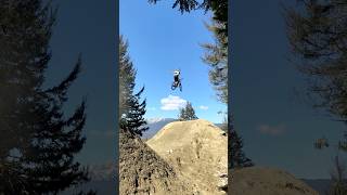
A highly revered trail at the whistler bike park. Could be considered one of the hardest trails there.The trail is pretty much all jumps with the biggest one coming in at about 65 feet.

Bike Park

Recent Activity on Trail

Past Week
  • 28 rides
  • 35.5 km average
6 Months
  • 228 rides
  • 37.2 km avg distance
All
  • 3,161 rides
  • Last: Jun 24, 2026
c1c2c3c4
January
February
March
April
May
June
July
August
September
October
November
December
update trails status or condition

Crabapple Hits Trail Reports

Status:
on May 19, 2026
Avg: 4.44 (46 votes)
Your vote: 0

view (22,235)
close
3D
Trail Conditions
  • Unknown
  • Snow Groomed
  • Snow Packed
  • Snow Covered
  • Snow Cover Partial
  • Freeze/thaw Cycle
  • Icy
  • Prevalent Mud
  • Wet
  • Variable
  • Ideal
  • Dry
  • Very Dry
Trail Flow (Ridden Direction)
Trailforks scans users ridelogs to determine the most popular direction each trail is ridden. A good flowing trail network will have most trails flowing in a single direction according to their intension.
The colour categories are based on what percentage of riders are riding a trail in its intended direction.
  • > 96%
  • > 90%
  • > 80%
  • > 70%
  • > 50%
  • < 50%
  • bi-directional trail
  • no data
Trail Last Ridden
Trailforks scans ridelogs to determine the last time a trail was ridden.
  • < 2 days
  • < 1 week
  • < 2 weeks
  • < 1 month
  • < 6 months
  • > 6 months
Trail Ridden Direction
The intended direction a trail should be ridden.
  • Downhill Only
  • Downhill Primary
  • Both Directions
  • Uphill Primary
  • Uphill Only
  • One Direction
Contribute Details
Colors indicate trail is missing specified detail.
  • Description
  • Photos
  • Description & Photos
  • Videos
Trail Popularity ?
Trailforks scans ridelogs to determine which trails are ridden the most in the last 9 months. Trails are compared with nearby trails in the same city region with a possible 25 colour shades. Think of this as a heatmap, more rides = more kinetic energy = warmer colors.
  • most popular
  • popular
  • less popular
  • not popular
ATV/ORV/OHV Filter
Max Vehicle Width
inches
US Cell Coverage
Legend
cell carrier legend

Radar Time
Activity Recordings
Trailforks uses anonymized public activity data. ?
Activity Recordings
Trailforks uses anonymized public activity data. ?
Personal Heatmap
Activity Types
all / none
Options
2
Date range month
Winter Trails
Warning A routing network for winter maps does not exist. Selecting trails using the winter trails layer has been disabled.
Missing Trails
Most Popular
Least Popular
Trails are colored based on popularity. The more popular a trail is, the more red. Less popular trails trend towards green.
Jump Magnitude Heatmap
Heatmap of where riders jump on trails. Zoom in to see individual jumps, click circles to view jump details.
BC Backroad Status

Service Road Atlas is a free to use, community-driven service for viewing and creating reports on the numerous back-country service roads around B.C. and Alberta.

map legend
Slope Aspect
Direction the slope faces
Flat N NE E SE S SW W NW
Trails Deemphasized
Trails are shown in grey.
disable
Only show trails with no bike usage.
Enable
Suggested Layers
Based on selected activity type

    Save the current map location and zoom level as your default home location whenever this page is loaded.

    Save
        Directions to crabapple-hits trailhead (50.099690, -122.955760)

        Photos

        1,527 more »
        209 |
        Jan 12, 2018 @ 9:24am
        Jan 12, 2018
        204 |
        Aug 28, 2017 @ 12:46pm
        Aug 28, 2017
        5,308 |
        Oct 10, 2018 @ 9:44am
        Oct 10, 2018
        9,719 |
        Nov 4, 2015 @ 8:57pm
        Nov 4, 2015

        Videos

        182 more »
        youtuber I'M THE KING OF THE WORLD  #mtb #whistler...
        0:14 | 214 | Sep 21, 2025 , Whistler
        youtuber Riding Crazy New Lines and FULLY SENDING IT AT...
        20:07 | 1294 | Oct 22, 2021 , Whistler
        youtuber Crabapple Hits |  The biggest jumps I've ever...
        2:00 | 2806 | Jul 22, 2019 , Whistler
        youtuber Official Whip-Off World Championships at...
        2:41 | 1785 | Aug 18, 2018 , Whistler

        Routes with this trail

        5,203 ft 4 Point to Point Race
        Phat Wednesday Race #2 - June 7, 2017
        2.0 24 miles 10,155 ft 32 Point to Point Race
        The course route for the 2023 Canadian Open Enduro TRAINING | Saturday, 27th July 8:00 am – 3:30 pm RACE...

        10 Reviews & Comments


        We hope you've been enjoying Trailforks!

        Create a FREE account to view trail comments and much more.

        • By JCNorthshoreAM & contributors
        • #2467 - 36,559 views

        Frequently Asked Questions About Crabapple Hits

        Where is Crabapple Hits located?
        Crabapple Hits is located in Whistler Mountain Bike Park, Whistler, British Columbia, Canada. It is part of the Whistler Mountain Bike Park trail network. The trailhead is located at coordinates 50.09969, -122.95576.
        How hard is Crabapple Hits?
        Crabapple Hits is rated as Proline difficulty. The average grade is 13.2%.
        What is the elevation gain for Crabapple Hits?
        The trail has 60 m of elevation descent. The elevation ranges from 893 m to 953 m.
        How long is Crabapple Hits?
        Crabapple Hits is 452.0 m long. The trail type is singletrack.

        Hit the Trail

        Open in App

        Get this trail on your phone instantly.
        open trail in app

        Download Trail

        Save to wishlist, Garmin & download.
        save the trail

        Find Related Routes

        Find routes and users activities that include this trail.
        find routes for this trail

        You must enter a description before submitting.