more stats
3,002 ft
Distance
-463 ft
Descent
00:03:27
Avg time
-462 ft
Altitude change
2,673 ft
Altitude min
3,135 ft
Altitude max
3,135 ft
Altitude start
2,674 ft
Altitude end
-15.4%
Grade
-51.2%
Grade max
2.3%
Grade min
43 ft
Distance climb
2,871 ft
Distance down
69 ft
Distance flat
00:03:27
Avg time

Cravarezza Details

  • Activities
    • Mountain Bike
    • E-Bike
    • Gravel Bike
    • Adaptive Bike
  • Riding Area
    Finale Outdoor Region
    Finale Ligure
  • Ref Number
    #98
  • Difficulty Rating
  • Voted Difficulty
    Blue (4 votes)
  • Local Popularity
    100 in Mountain Biking [+]
    • 100 in E-Biking
  • Global Ranking
    #51 in Mountain Biking [+]
    • #1596 in E-Biking
  • Trail Type
    Doubletrack
  • Bike Type
    AM, XC, Gravel, Adaptive MTB
  • Direction
    Downhill Only
    Popular Direction Shown
  • Climb Difficulty
    Green
  • Physical Rating
    Moderate
  • Trail Visibility
    Always easy to follow
  • Season
    All-year round
  • Dogs Allowed
    Yes
  • eBike Allowed
    Yes up to Class 1
  • Land Owner
    Finale Outdoor Region

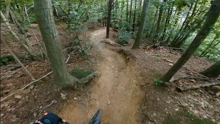
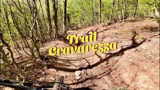
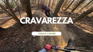
Cravarezza takes its name from the crossroad that the trails starts from: Colla Cravarezza. By many considered the first part of the Ingegnere Trail, it was indeed used as the stage Ingegnere in 2015. It is definitely a nice start of a beautiful fast and challenging trail. Cravarezza features natural banks, rollers, flow, roots for a short, fast beautiful experience.

source: ...
Access Info

Nato Base Area is reachable from the E80 highway accessing Orco Feglino, then drive north on the SP23 until the windmills under the Base.

Disclaimer

Given its nature, the trail can change after weather happenings and season changes. Always pay attention.

Trail Supporters
Local Trail Association

Recent Activity on Trail

Past Week
  • 7 rides
  • 13 miles average
6 Months
  • 358 rides
  • 23 miles avg distance
All
  • 2,395 rides
  • Last: Jun 26, 2026
c1c2c3c4
January
February
March
April
May
June
July
August
September
October
November
December
Status:
on Jun 11, 2026
Ideal
Avg: 4.64 (74 votes)
Your vote: 0

view (15,021)
close
3D
Trail Conditions
  • Unknown
  • Snow Groomed
  • Snow Packed
  • Snow Covered
  • Snow Cover Partial
  • Freeze/thaw Cycle
  • Icy
  • Prevalent Mud
  • Wet
  • Variable
  • Ideal
  • Dry
  • Very Dry
Trail Flow (Ridden Direction)
Trailforks scans users ridelogs to determine the most popular direction each trail is ridden. A good flowing trail network will have most trails flowing in a single direction according to their intension.
The colour categories are based on what percentage of riders are riding a trail in its intended direction.
  • > 96%
  • > 90%
  • > 80%
  • > 70%
  • > 50%
  • < 50%
  • bi-directional trail
  • no data
Trail Last Ridden
Trailforks scans ridelogs to determine the last time a trail was ridden.
  • < 2 days
  • < 1 week
  • < 2 weeks
  • < 1 month
  • < 6 months
  • > 6 months
Trail Ridden Direction
The intended direction a trail should be ridden.
  • Downhill Only
  • Downhill Primary
  • Both Directions
  • Uphill Primary
  • Uphill Only
  • One Direction
Contribute Details
Colors indicate trail is missing specified detail.
  • Description
  • Photos
  • Description & Photos
  • Videos
Trail Popularity ?
Trailforks scans ridelogs to determine which trails are ridden the most in the last 9 months. Trails are compared with nearby trails in the same city region with a possible 25 colour shades. Think of this as a heatmap, more rides = more kinetic energy = warmer colors.
  • most popular
  • popular
  • less popular
  • not popular
ATV/ORV/OHV Filter
Max Vehicle Width
inches
US Cell Coverage
Legend
cell carrier legend

Radar Time
Activity Recordings
Trailforks uses anonymized public activity data. ?
Activity Recordings
Trailforks uses anonymized public activity data. ?
Personal Heatmap
Activity Types
all / none
Options
2
Date range month
Winter Trails
Warning A routing network for winter maps does not exist. Selecting trails using the winter trails layer has been disabled.
Missing Trails
Most Popular
Least Popular
Trails are colored based on popularity. The more popular a trail is, the more red. Less popular trails trend towards green.
Jump Magnitude Heatmap
Heatmap of where riders jump on trails. Zoom in to see individual jumps, click circles to view jump details.
BC Backroad Status

Service Road Atlas is a free to use, community-driven service for viewing and creating reports on the numerous back-country service roads around B.C. and Alberta.

map legend
Slope Aspect
Direction the slope faces
Flat N NE E SE S SW W NW
Trails Deemphasized
Trails are shown in grey.
disable
Only show trails with no bike usage.
Enable
Suggested Layers
Based on selected activity type

    Save the current map location and zoom level as your default home location whenever this page is loaded.

    Save
        Directions to cravarezza trailhead (44.257790, 8.286040)

        Photos

        6 more »
        60 |
        Mar 9, 2025 @ 12:28pm
        Mar 9, 2025
        61 |
        Mar 9, 2025 @ 12:28pm
        Mar 9, 2025
        67 |
        Mar 8, 2025 @ 9:08am
        Mar 8, 2025
        61 |
        Mar 8, 2025 @ 9:08am
        Mar 8, 2025

        Videos

        12 more »
        youtuber Cravarezza - Finale Ligure | Finale Outdoor Region
        2:28 | 353 | Nov 29, 2023 , Finale Ligure
        Trail Crestino1(intro)+Cravarezza - Finale...
        6:28 | 78 | Apr 26, 2025 , Finale Ligure
        youtuber Cravarezza Level Blue Finale Ligure Italy ...
        2:49 | 97 | Jan 5, 2025 , Finale Ligure
        Finale Ligure eMTBing . Trail Cravarezza with...
        5:55 | 80 | Dec 29, 2024 , Finale Ligure

        Routes with this trail

        4 miles 32 ft 2
        Single lift zu Base Nato, dann via Crestino1 und Cravarezza zu Ingegnere
        4 miles 48 ft 2
        single lift zu base nato, dann via Cravarezza und Crestino1 zu Ingegnere
        2.0 19 miles 1,407 ft 5 Shuttled
        All mountain trip starting at nato base and finishing at the level of the sea!

        3 Reviews & Comments


        We hope you've been enjoying Trailforks!

        Create a FREE account to view trail comments and much more.

        Frequently Asked Questions About Cravarezza

        Where is Cravarezza located?
        Cravarezza is located in Finale Outdoor Region, Finale Ligure, Italy. It is part of the Finale Outdoor Region trail network. The trailhead is located at coordinates 44.25779, 8.28604.
        How hard is Cravarezza?
        Cravarezza is rated as Blue difficulty. The physical rating is Moderate. The average grade is 15.4%. The climb difficulty is rated Green.
        What is the elevation gain for Cravarezza?
        The trail has 463 ft of elevation descent. The elevation ranges from 2,673 ft to 3,135 ft.
        Is Cravarezza a point to point trail?
        Yes, Cravarezza is a point to point trail. The direction is Downhill Only. The trail type is doubletrack.

        Hit the Trail

        Open in App

        Get this trail on your phone instantly.
        open trail in app

        Download Trail

        Save to wishlist, Garmin & download.
        save the trail

        Find Related Routes

        Find routes and users activities that include this trail.
        find routes for this trail

        You must enter a description before submitting.