more stats
4,088 ft
Distance
-639 ft
Descent
00:11:34
Avg time
-639 ft
Altitude change
2,584 ft
Altitude min
3,223 ft
Altitude max
3,223 ft
Altitude start
2,585 ft
Altitude end
-15.6%
Grade
-58.1%
Grade max
1%
Grade min
66 ft
Distance climb
3,973 ft
Distance down
49 ft
Distance flat
00:11:34
Avg time

Crazy Merry Details

  • Activities
    • Mountain Bike
    • E-Bike
  • Riding Area
    Merry Creek
    Castlegar, British Columbia
  • Difficulty Rating
  • Voted Difficulty
    Double Black Diamond (1 vote)
  • Local Popularity
    90 in Mountain Biking [+]
    • 75 in E-Biking
  • Global Ranking
    #49151 in Mountain Biking [+]
    • #50632 in E-Biking
  • Trail Type
    Singletrack
  • Bike Type
    DH, AM
  • Direction
    Downhill Primary
    Popular Direction Shown
  • Dogs Allowed
    Yes
  • eBike Allowed
  • TTFs on Trail
    Berm, Bridge, Jump, Gap Jump, Skinny
  • Land Owner

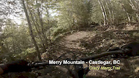
Another trail showcasing the skills and dedication of the volunteers of Castlegar and the West Kootenays, this trail will test your mettle with the gap jumps on a few huge features. It's a super smooth ride for those looking to check it out.
The trail is hand built but looks like it was built by a machine.

"Pre-ride" Inspect trail and features at slow speed
"Re-ride" Lap the trail until you feel comfortable with the flow of the features.
"Freeride" Start small and work your way up to faster speeds and larger features

This trail was built by volunteers and with the help from the Castlegar Parks & Trails Society and Recreation Sites and Trails BC making this a sanctioned trail.

Want more trails? Then become a member of the Castlegar Parks and Trails Society for only $10 a year.

Access Info

Drive 2.2km up the Merry Creek FSR located just outside Castlegar on Hwy 3 heading toward Christina lake.
At 2.2km you will see a parking area, park there and access the trail climbing trail Merry Go Round located on the other side of the road from the parking area. There is a kiosk there with a map. The trails are well marked.

Local Trail Association

Recent Activity on Trail

Past Week
  • 2 rides
  • 15.9 km average
6 Months
  • 20 rides
  • 10.9 km avg distance
All
  • 196 rides
  • Last: Jun 19, 2026
c1c2c3c4
January
February
March
April
May
June
July
August
September
October
November
December
update trails status or condition

Crazy Merry Trail Reports

statusdatedescription
May 21, 2026 @ 4:52pm (America/Creston)
May 21, 2026
All trees cleared, trail is running well.
Apr 20, 2026 @ 10:48am (America/Vancouver)
Apr 20, 2026
2 trees across bridge after wooden step up & long skinny as you drop into the forest
Apr 7, 2026 @ 6:29pm (America/Vancouver)
Apr 7, 2026
Step down lip is falling apart. No other issues.
Nov 2, 2025 @ 12:55pm (America/Creston)
Nov 2, 2025
Trail clear and running well
Sep 5, 2025 @ 1:59pm
Sep 5, 2025
more »
Status:
on May 21, 2026
Ideal
Avg: 4.42 (13 votes)
Your vote: 0

view (1,050)
close
3D
Trail Conditions
  • Unknown
  • Snow Groomed
  • Snow Packed
  • Snow Covered
  • Snow Cover Partial
  • Freeze/thaw Cycle
  • Icy
  • Prevalent Mud
  • Wet
  • Variable
  • Ideal
  • Dry
  • Very Dry
Trail Flow (Ridden Direction)
Trailforks scans users ridelogs to determine the most popular direction each trail is ridden. A good flowing trail network will have most trails flowing in a single direction according to their intension.
The colour categories are based on what percentage of riders are riding a trail in its intended direction.
  • > 96%
  • > 90%
  • > 80%
  • > 70%
  • > 50%
  • < 50%
  • bi-directional trail
  • no data
Trail Last Ridden
Trailforks scans ridelogs to determine the last time a trail was ridden.
  • < 2 days
  • < 1 week
  • < 2 weeks
  • < 1 month
  • < 6 months
  • > 6 months
Trail Ridden Direction
The intended direction a trail should be ridden.
  • Downhill Only
  • Downhill Primary
  • Both Directions
  • Uphill Primary
  • Uphill Only
  • One Direction
Contribute Details
Colors indicate trail is missing specified detail.
  • Description
  • Photos
  • Description & Photos
  • Videos
Trail Popularity ?
Trailforks scans ridelogs to determine which trails are ridden the most in the last 9 months. Trails are compared with nearby trails in the same city region with a possible 25 colour shades. Think of this as a heatmap, more rides = more kinetic energy = warmer colors.
  • most popular
  • popular
  • less popular
  • not popular
ATV/ORV/OHV Filter
Max Vehicle Width
inches
US Cell Coverage
Legend
cell carrier legend

Radar Time
Activity Recordings
Trailforks uses anonymized public activity data. ?
Activity Recordings
Trailforks uses anonymized public activity data. ?
Personal Heatmap
Activity Types
all / none
Options
2
Date range month
Winter Trails
Warning A routing network for winter maps does not exist. Selecting trails using the winter trails layer has been disabled.
Missing Trails
Most Popular
Least Popular
Trails are colored based on popularity. The more popular a trail is, the more red. Less popular trails trend towards green.
Jump Magnitude Heatmap
Heatmap of where riders jump on trails. Zoom in to see individual jumps, click circles to view jump details.
BC Backroad Status

Service Road Atlas is a free to use, community-driven service for viewing and creating reports on the numerous back-country service roads around B.C. and Alberta.

map legend
Slope Aspect
Direction the slope faces
Flat N NE E SE S SW W NW
Trails Deemphasized
Trails are shown in grey.
disable
Only show trails with no bike usage.
Enable
Suggested Layers
Based on selected activity type

    Save the current map location and zoom level as your default home location whenever this page is loaded.

    Save
        Directions to crazy-merry trailhead (49.287970, -117.685640)

        Photos

        44 more »
        707 |
        Aug 27, 2018 @ 8:43pm
        Aug 27, 2018
        838 |
        Jun 13, 2017 @ 10:06pm
        Jun 13, 2017
        80 |
        Jun 22, 2024 @ 9:16am
        Jun 22, 2024
        69 |
        Jun 22, 2024 @ 9:19am
        Jun 22, 2024

        Videos

        6 more »
        Remy Metailler Challenge!
        2:48 | 150 | Aug 15, 2024 , Castlegar
        Bike club fail
        0:10 | 707 | Oct 27, 2021 , Castlegar
        Crazy Merry
        4:02 | 706 | Oct 4, 2020 , Castlegar
        Crazy Merry - Castlegar, BC
        5:00 | 363 | Sep 22, 2019 , Castlegar

        4 Reviews & Comments


        We hope you've been enjoying Trailforks!

        Create a FREE account to view trail comments and much more.

        • By mountaintowndaveTF Pro CPTS & contributors
        • #102124 - 6,711 views

        Frequently Asked Questions About Crazy Merry

        Where is Crazy Merry located?
        Crazy Merry is located in Merry Creek, Castlegar, British Columbia, Canada. It is part of the Merry Creek trail network. The trailhead is located at coordinates 49.28797, -117.68564.
        How hard is Crazy Merry?
        Crazy Merry is rated as Double Black Diamond difficulty. The average grade is 15.6%.
        What is the elevation gain for Crazy Merry?
        The trail has 639 ft of elevation descent. The elevation ranges from 2,584 ft to 3,223 ft.
        Is Crazy Merry a point to point trail?
        Crazy Merry is not a point to point trail. The direction is Downhill Primary. The trail type is singletrack.

        Hit the Trail

        Open in App

        Get this trail on your phone instantly.
        open trail in app

        Download Trail

        Save to wishlist, Garmin & download.
        save the trail

        Find Related Routes

        Find routes and users activities that include this trail.
        find routes for this trail

        You must enter a description before submitting.