more stats
4,885 ft
Distance
-1,042 ft
Descent
00:09:58
Avg time
-1,042 ft
Altitude change
4,066 ft
Altitude min
5,108 ft
Altitude max
5,108 ft
Altitude start
4,065 ft
Altitude end
-21.3%
Grade
-66.8%
Grade max
1.8%
Grade min
33 ft
Distance climb
4,852 ft
Distance down
00:09:58
Avg time

Crazy Train Details

  • Activities
    • Mountain Bike
    • E-Bike
  • Riding Area
    Panorama Mountain Resort
    Panorama, British Columbia
  • Difficulty Rating
  • Voted Difficulty
    Double Black Diamond (1 vote)
  • Local Popularity
    65 in Mountain Biking [+]
    • 75 in E-Biking
  • Global Ranking
    #65936 in Mountain Biking [+]
    • #55053 in E-Biking
  • Trail Type
    Singletrack
  • Bike Type
    DH
  • Direction
    Downhill Only
    Popular Direction Shown
  • eBike Allowed
    Yes up to Class 1
  • Land Owner

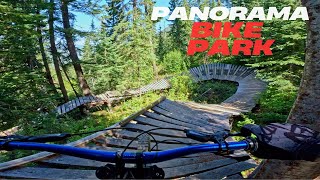
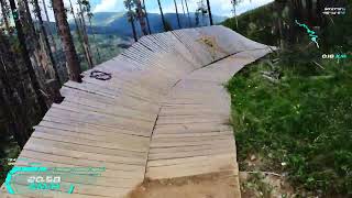
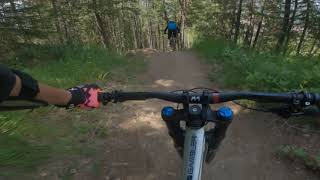
Old school trail which has it all - drops, jumps, wooden features and a whole lot of tech. Rider's need to be confident on the first drop and wooden feature to enjoy this trail. The lower section has many slopestyle type features and large berms. All aboard

Bike Park

Recent Activity on Trail

Past Week
  • 0 rides
  •  
6 Months
  • 0 rides
  •  
All
  • 65 rides
  • Last: Aug 31, 2025
c1c2c3c4
January
February
March
April
May
June
July
August
September
October
November
December
update trails status or condition

Crazy Train Trail Reports

Status:
on Sep 2, 2025
Variable
Avg: 4.35 (15 votes)
Your vote: 0

view (966)
close
3D
Trail Conditions
  • Unknown
  • Snow Groomed
  • Snow Packed
  • Snow Covered
  • Snow Cover Partial
  • Freeze/thaw Cycle
  • Icy
  • Prevalent Mud
  • Wet
  • Variable
  • Ideal
  • Dry
  • Very Dry
Trail Flow (Ridden Direction)
Trailforks scans users ridelogs to determine the most popular direction each trail is ridden. A good flowing trail network will have most trails flowing in a single direction according to their intension.
The colour categories are based on what percentage of riders are riding a trail in its intended direction.
  • > 96%
  • > 90%
  • > 80%
  • > 70%
  • > 50%
  • < 50%
  • bi-directional trail
  • no data
Trail Last Ridden
Trailforks scans ridelogs to determine the last time a trail was ridden.
  • < 2 days
  • < 1 week
  • < 2 weeks
  • < 1 month
  • < 6 months
  • > 6 months
Trail Ridden Direction
The intended direction a trail should be ridden.
  • Downhill Only
  • Downhill Primary
  • Both Directions
  • Uphill Primary
  • Uphill Only
  • One Direction
Contribute Details
Colors indicate trail is missing specified detail.
  • Description
  • Photos
  • Description & Photos
  • Videos
Trail Popularity ?
Trailforks scans ridelogs to determine which trails are ridden the most in the last 9 months. Trails are compared with nearby trails in the same city region with a possible 25 colour shades. Think of this as a heatmap, more rides = more kinetic energy = warmer colors.
  • most popular
  • popular
  • less popular
  • not popular
ATV/ORV/OHV Filter
Max Vehicle Width
inches
US Cell Coverage
Legend
cell carrier legend

Radar Time
Activity Recordings
Trailforks uses anonymized public activity data. ?
Activity Recordings
Trailforks uses anonymized public activity data. ?
Personal Heatmap
Activity Types
all / none
Options
2
Date range month
Winter Trails
Warning A routing network for winter maps does not exist. Selecting trails using the winter trails layer has been disabled.
Missing Trails
Most Popular
Least Popular
Trails are colored based on popularity. The more popular a trail is, the more red. Less popular trails trend towards green.
Jump Magnitude Heatmap
Heatmap of where riders jump on trails. Zoom in to see individual jumps, click circles to view jump details.
BC Backroad Status

Service Road Atlas is a free to use, community-driven service for viewing and creating reports on the numerous back-country service roads around B.C. and Alberta.

map legend
Slope Aspect
Direction the slope faces
Flat N NE E SE S SW W NW
Trails Deemphasized
Trails are shown in grey.
disable
Only show trails with no bike usage.
Enable
Suggested Layers
Based on selected activity type

    Save the current map location and zoom level as your default home location whenever this page is loaded.

    Save
        Directions to crazy-train trailhead (50.445240, -116.228640)

        Photos

        15 more »
        2,030 |
        Nov 14, 2014 @ 10:46am
        Nov 14, 2014
        936 |
        Mar 6, 2014 @ 1:49pm
        Mar 6, 2014
        351 |
        Jun 20, 2017 @ 8:56am
        Jun 20, 2017
        129 |
        Jul 20, 2022 @ 11:47pm
        Jul 20, 2022

        Videos

        22 more »
        youtuber Canada's most UNDERRATED bike park - Panorama...
        21:53 | 69 | Nov 24, 2025 , Panorama
        Panorama Mountain Resort - Crazy Train ◇
        7:25 | 436 | Sep 22, 2022 , Panorama
        Crazy Train Panorama, BC
        5:43 | 442 | Jul 27, 2021 , Panorama
        Panorama Bike Park - Crazy Train
        5:15 | 610 | Sep 15, 2020 , Panorama

        2 Reviews & Comments


        We hope you've been enjoying Trailforks!

        Create a FREE account to view trail comments and much more.

        • By Tekmisfit & contributors
        • #2445 - 6,480 views

        Frequently Asked Questions About Crazy Train

        Where is Crazy Train located?
        Crazy Train is located in Panorama Mountain Resort, Panorama, British Columbia, Canada. It is part of the Panorama Mountain Resort trail network. The trailhead is located at coordinates 50.44524, -116.22864.
        How hard is Crazy Train?
        Crazy Train is rated as Double Black Diamond difficulty. The average grade is 21.3%.
        What is the elevation gain for Crazy Train?
        The trail has 1,042 ft of elevation descent. The elevation ranges from 4,066 ft to 5,108 ft.
        Is Crazy Train a point to point trail?
        Yes, Crazy Train is a point to point trail. The direction is Downhill Only. The trail type is singletrack.

        Hit the Trail

        Open in App

        Get this trail on your phone instantly.
        open trail in app

        Download Trail

        Save to wishlist, Garmin & download.
        save the trail

        Find Related Routes

        Find routes and users activities that include this trail.
        find routes for this trail

        You must enter a description before submitting.