more stats
1.3 miles
Distance
20 ft
Climb
-349 ft
Descent
00:10:12
Avg time
-332 ft
Altitude change
1,374 ft
Altitude min
1,713 ft
Altitude max
1,706 ft
Altitude start
1,375 ft
Altitude end
-4.8%
Grade
-30.2%
Grade max
5.7%
Grade min
1,237 ft
Distance climb
4,879 ft
Distance down
748 ft
Distance flat
00:10:12
Avg time

Crest Trail Details

  • Activities
    • Mountain Bike
    • E-Bike
    • Hike
    • Trail Running
  • Riding Area
    Daley Ranch
    Escondido, California
  • Difficulty Rating
  • Voted Difficulty
    Black Diamond (4 votes)
  • Local Popularity
    100 in Mountain Biking [+]
    • 100 in E-Biking
    • 90 in Trail Running
    • 35 in Hiking
  • Global Ranking
    #29197 in Mountain Biking [+]
    • #3465 in E-Biking
    • #21922 in Trail Running
    • #119193 in Hiking
  • Trail Type
    Singletrack
  • Bike Type
    AM, XC
  • Direction
    Downhill Primary
    Popular Direction Shown
  • Dogs Allowed
    Yes
  • eBike Allowed
    Yes up to Class 1

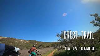
The BEST DH at Daley Ranch if not in all of North San Diego County. Twisty, bumpy, fast with a couple burst climbs and a long straight high speed down in the middle.

Local Trail Association
Traditionally Indigenous Territory

Recent Activity on Trail

Past Week
  • 4 rides
  • 12 miles average
6 Months
  • 122 rides
  • 14 miles avg distance
All
  • 722 rides
  • Last: Jun 20, 2026
c1c2c3c4
January
February
March
April
May
June
July
August
September
October
November
December
update trails status or condition

Crest Trail Trail Reports

statusdatedescription
Dec 17, 2025 @ 10:23am (America/Los_Angeles)
Dec 17, 2025
Riding nice today! Some ruts...in all the right places! Lol! :)
Nov 24, 2025 @ 8:54am (America/Los_Angeles)
Nov 24, 2025
HERO DIRT!!!!
Nov 2, 2025 @ 8:08am (America/Los_Angeles)
Nov 2, 2025
Could use some bushwhacking near the top but less dusty than I'd expected.
Jun 8, 2025 @ 8:38am
Jun 8, 2025
Jun 1, 2025 @ 5:29am
Jun 1, 2025
more »
Status:
on Dec 17, 2025
Ideal
Avg: 4.63 (22 votes)
Your vote: 0

view (4,821)
close
3D
Trail Conditions
  • Unknown
  • Snow Groomed
  • Snow Packed
  • Snow Covered
  • Snow Cover Partial
  • Freeze/thaw Cycle
  • Icy
  • Prevalent Mud
  • Wet
  • Variable
  • Ideal
  • Dry
  • Very Dry
Trail Flow (Ridden Direction)
Trailforks scans users ridelogs to determine the most popular direction each trail is ridden. A good flowing trail network will have most trails flowing in a single direction according to their intension.
The colour categories are based on what percentage of riders are riding a trail in its intended direction.
  • > 96%
  • > 90%
  • > 80%
  • > 70%
  • > 50%
  • < 50%
  • bi-directional trail
  • no data
Trail Last Ridden
Trailforks scans ridelogs to determine the last time a trail was ridden.
  • < 2 days
  • < 1 week
  • < 2 weeks
  • < 1 month
  • < 6 months
  • > 6 months
Trail Ridden Direction
The intended direction a trail should be ridden.
  • Downhill Only
  • Downhill Primary
  • Both Directions
  • Uphill Primary
  • Uphill Only
  • One Direction
Contribute Details
Colors indicate trail is missing specified detail.
  • Description
  • Photos
  • Description & Photos
  • Videos
Trail Popularity ?
Trailforks scans ridelogs to determine which trails are ridden the most in the last 9 months. Trails are compared with nearby trails in the same city region with a possible 25 colour shades. Think of this as a heatmap, more rides = more kinetic energy = warmer colors.
  • most popular
  • popular
  • less popular
  • not popular
ATV/ORV/OHV Filter
Max Vehicle Width
inches
US Cell Coverage
Legend
cell carrier legend

Radar Time
Activity Recordings
Trailforks uses anonymized public activity data. ?
Activity Recordings
Trailforks uses anonymized public activity data. ?
Personal Heatmap
Activity Types
all / none
Options
2
Date range month
Winter Trails
Warning A routing network for winter maps does not exist. Selecting trails using the winter trails layer has been disabled.
Missing Trails
Most Popular
Least Popular
Trails are colored based on popularity. The more popular a trail is, the more red. Less popular trails trend towards green.
Jump Magnitude Heatmap
Heatmap of where riders jump on trails. Zoom in to see individual jumps, click circles to view jump details.
BC Backroad Status

Service Road Atlas is a free to use, community-driven service for viewing and creating reports on the numerous back-country service roads around B.C. and Alberta.

map legend
Slope Aspect
Direction the slope faces
Flat N NE E SE S SW W NW
Trails Deemphasized
Trails are shown in grey.
disable
Only show trails with no bike usage.
Enable
Suggested Layers
Based on selected activity type

    Save the current map location and zoom level as your default home location whenever this page is loaded.

    Save
        Directions to crest-trail trailhead (33.187410, -117.061350)

        Photos

        21 more »
        118 |
        Jan 31, 2023 @ 2:52pm
        Jan 31, 2023
        104 |
        Jul 7, 2022 @ 12:58pm
        Jul 7, 2022
        115 |
        Jul 7, 2022 @ 12:58pm
        Jul 7, 2022
        131 |
        Jul 7, 2022 @ 12:58pm
        Jul 7, 2022

        Videos

        12 more »
        Daley Ranch - Riding until sunset - One of the...
        9:40 | 345 | Dec 30, 2022 , Escondido
        youtuber MTB Riding Crest Trail | Daley Ranch |...
        7:59 | 272 | Nov 22, 2022 , Escondido
        Daley Ranch Part 3 of 3 | Crest Trail | San...
        6:12 | 386 | Jan 31, 2022 , Escondido
        My Favorite Bits of Trail at Daley Ranch
        10:20 | 171 | Jan 18, 2022 , Escondido

        Routes with this trail

        4.0 18 miles 3,003 ft 30 Loop
        A Daley Ranch route of 9 of the "Top 10 most popular trails in Escondido" to earn the Trailforks badge....
        3.0 15 miles 2,104 ft 10 Loop
        Fast, fun and flowy technical single track is what this ride is all about. You've got to put in the work...
        3.0 9 miles 1,295 ft 9 Loop
        Daley Ranch is a great place to ride, assuming you are willing to accept lots of fireroad. But as the ,...

        3 Reviews & Comments


        We hope you've been enjoying Trailforks!

        Create a FREE account to view trail comments and much more.

        • By The-dirt-farmerTF Pro & contributors
        • #29944 - 4,851 views

        Frequently Asked Questions About Crest Trail

        Where is Crest Trail located?
        Crest Trail is located in Daley Ranch, Escondido, California, United States. It is part of the Daley Ranch trail network. The trailhead is located at coordinates 33.18741, -117.06135.
        How hard is Crest Trail?
        Crest Trail is rated as Blue difficulty. The average grade is 4.8%.
        What is the elevation gain for Crest Trail?
        Crest Trail has 20 ft of elevation gain. The trail has 349 ft of elevation descent. The elevation ranges from 1,374 ft to 1,713 ft.
        Is Crest Trail a point to point trail?
        Crest Trail is not a point to point trail. The direction is Downhill Primary. The trail type is singletrack.

        Hit the Trail

        Open in App

        Get this trail on your phone instantly.
        open trail in app

        Download Trail

        Save to wishlist, Garmin & download.
        save the trail

        Find Related Routes

        Find routes and users activities that include this trail.
        find routes for this trail

        You must enter a description before submitting.