more stats
2,523 ft
Distance
85 ft
Climb
-12 ft
Descent
00:03:34
Avg time
73 ft
Altitude change
2,066 ft
Altitude min
2,139 ft
Altitude max
2,066 ft
Altitude start
2,139 ft
Altitude end
2.9%
Grade
-5.5%
Grade max
19.1%
Grade min
1,673 ft
Distance climb
427 ft
Distance down
427 ft
Distance flat
00:03:34
Avg time

Crim Track Details

  • Activities
    • Mountain Bike
  • Riding Area
  • Difficulty Rating
  • Local Popularity
    75 in Mountain Biking
  • Global Ranking
    #13389 in Mountain Biking
  • Trail Type
    Singletrack
  • Bike Type
    XC
  • Direction
    Uphill Only
    Popular Direction Shown
  • eBike Allowed
    Yes up to Class 1
  • Land Owner
    CMTEDD - National Arboretum Canberra/Stromlo Forest Park

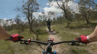
Starts where Double Dissolution ends. It is the beginning of the trails returning one to the frontside of Stromlo. An unapologetically pure XC track (loads of corners, some awkward, all while continuously going uphill) I reckon most of the trail bikes bypass Crim Track in favour of the adjacent firetrail.

Trail Supporters

Bike Park

Local Trail Association
Traditionally Indigenous Territory

Recent Activity on Trail

Past Week
  • 11 rides
  • 11 miles average
6 Months
  • 210 rides
  • 13 miles avg distance
All
  • 1,938 rides
  • Last: Jul 6, 2019
c1c2c3c4
January
February
March
April
May
June
July
August
September
October
November
December
Status:
on May 26, 2026
Wet
Avg: 3.81 (5 votes)
Your vote: 0

view (15,012)
close
3D
Trail Conditions
  • Unknown
  • Snow Groomed
  • Snow Packed
  • Snow Covered
  • Snow Cover Partial
  • Freeze/thaw Cycle
  • Icy
  • Prevalent Mud
  • Wet
  • Variable
  • Ideal
  • Dry
  • Very Dry
Trail Flow (Ridden Direction)
Trailforks scans users ridelogs to determine the most popular direction each trail is ridden. A good flowing trail network will have most trails flowing in a single direction according to their intension.
The colour categories are based on what percentage of riders are riding a trail in its intended direction.
  • > 96%
  • > 90%
  • > 80%
  • > 70%
  • > 50%
  • < 50%
  • bi-directional trail
  • no data
Trail Last Ridden
Trailforks scans ridelogs to determine the last time a trail was ridden.
  • < 2 days
  • < 1 week
  • < 2 weeks
  • < 1 month
  • < 6 months
  • > 6 months
Trail Ridden Direction
The intended direction a trail should be ridden.
  • Downhill Only
  • Downhill Primary
  • Both Directions
  • Uphill Primary
  • Uphill Only
  • One Direction
Contribute Details
Colors indicate trail is missing specified detail.
  • Description
  • Photos
  • Description & Photos
  • Videos
Trail Popularity ?
Trailforks scans ridelogs to determine which trails are ridden the most in the last 9 months. Trails are compared with nearby trails in the same city region with a possible 25 colour shades. Think of this as a heatmap, more rides = more kinetic energy = warmer colors.
  • most popular
  • popular
  • less popular
  • not popular
ATV/ORV/OHV Filter
Max Vehicle Width
inches
US Cell Coverage
Legend
cell carrier legend

Radar Time
Activity Recordings
Trailforks uses anonymized public activity data. ?
Activity Recordings
Trailforks uses anonymized public activity data. ?
Personal Heatmap
Activity Types
all / none
Options
2
Date range month
Winter Trails
Warning A routing network for winter maps does not exist. Selecting trails using the winter trails layer has been disabled.
Missing Trails
Most Popular
Least Popular
Trails are colored based on popularity. The more popular a trail is, the more red. Less popular trails trend towards green.
Jump Magnitude Heatmap
Heatmap of where riders jump on trails. Zoom in to see individual jumps, click circles to view jump details.
BC Backroad Status

Service Road Atlas is a free to use, community-driven service for viewing and creating reports on the numerous back-country service roads around B.C. and Alberta.

map legend
Slope Aspect
Direction the slope faces
Flat N NE E SE S SW W NW
Trails Deemphasized
Trails are shown in grey.
disable
Only show trails with no bike usage.
Enable
Suggested Layers
Based on selected activity type

    Save the current map location and zoom level as your default home location whenever this page is loaded.

    Save
        Directions to crim-track trailhead (-35.300860, 149.007920)

        Photos

        No photos have been added for Crim Track yet, add a photo.

        Videos

        2 more »
        Mount Stromlo MTB Park - Crim Track
        3:39 | 72 | Aug 6, 2024 , Canberra
        Stromlo Forrest - Crim Track (Green)
        3:34 | 359 | Jan 9, 2021 , Canberra

        Routes with this trail

        4.7 11 miles 1,179 ft 36
        RATING – INTERMEDIATE TIME – 90 TO 120 MINUTES Loop 4 is a full lap of Stromlo Forest Park’s...
        17 miles 2,501 ft 33
        Shimano 30 Course length 27km. Climbing 800m per lap. Approximately 75% of the trails in Stromlo used or...
        7 miles 990 ft 25
        RATING – INTERMEDIATE/ADVANCED TIME – 60 TO 90 MINUTES Loop 6 is a demanding ride that takes you over...

        1 Review & Comments


        We hope you've been enjoying Trailforks!

        Create a FREE account to view trail comments and much more.

        • By Jake-HannahTF Pro MPTA & contributors
        • #21281 - 1,891 views

        Frequently Asked Questions About Crim Track

        Where is Crim Track located?
        Crim Track is located in Stromlo Forest Park, Canberra, Australia. It is part of the Stromlo Forest Park trail network. The trailhead is located at coordinates -35.30086, 149.00792.
        How hard is Crim Track?
        Crim Track is rated as Green difficulty. The average grade is 2.9%.
        What is the elevation gain for Crim Track?
        Crim Track has 26 m of elevation gain. The trail has 4 m of elevation descent. The elevation ranges from 630 m to 652 m.
        Is Crim Track a point to point trail?
        Yes, Crim Track is a point to point trail. The direction is Uphill Only. The trail type is singletrack.

        Hit the Trail

        Open in App

        Get this trail on your phone instantly.
        open trail in app

        Download Trail

        Save to wishlist, Garmin & download.
        save the trail

        Find Related Routes

        Find routes and users activities that include this trail.
        find routes for this trail

        You must enter a description before submitting.