more stats
1.6 miles
Distance
160 ft
Climb
-231 ft
Descent
00:24:42
Avg time
-73 ft
Altitude change
2,914 ft
Altitude min
3,129 ft
Altitude max
2,987 ft
Altitude start
2,913 ft
Altitude end
-0.9%
Grade
-13.8%
Grade max
17.1%
Grade min
3,054 ft
Distance climb
3,842 ft
Distance down
1,329 ft
Distance flat
00:24:42
Avg time

Cub Scout Upper Details

  • Activities
    • Mountain Bike
    • Hike
    • Trail Running
  • Riding Area
    Boy Scout Trails
    Hurricane, Utah
  • Difficulty Rating
  • Local Popularity
    45 in Mountain Biking [+]
    • 5 in Trail Running
    • 5 in Hiking
  • Global Ranking
    #89241 in Mountain Biking [+]
    • #129195 in Trail Running
    • #122163 in Hiking
  • Trail Type
    Singletrack
  • Direction
    Both Directions
  • Climb Difficulty
    Black Diamond
  • Physical Rating
    Hard
  • Trail Visibility
    Always easy to follow
  • Season
    Year-round
  • Dogs Allowed
    Yes
  • eBike Allowed
  • Ride in Rain
    Yes
  • Land Owner

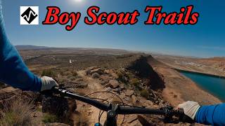
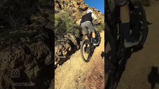
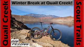
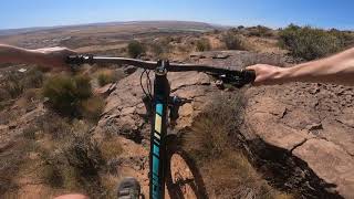
Relentlessly technical and balancy, like the rest of the Boy Scout Trails. Best ridden north to south. From the north, a series of mostly smooth, hairpin switchbacks ascend the mesa. With good line choice, you can get up to speed in a few places on the descent to the road. If you like flow trails look elsewhere.

Trail Supporters
  • BLM
    BLM
    Land Manager
Traditionally Indigenous Territory

Recent Activity on Trail

Past Week
  • 0 rides
  •  
6 Months
  • 7 rides
  • 7 miles avg distance
All
  • 124 rides
  • Last: May 24, 2026
c1c2c3c4
January
February
March
April
May
June
July
August
September
October
November
December
update trails status or condition

Cub Scout Upper Trail Reports

statusdatedescription
Feb 13, 2026 @ 7:15pm (America/Denver)
Feb 13, 2026
Great shape!
Jan 28, 2025 @ 8:22pm
Jan 28, 2025
Dry, but in great shape!
Jul 16, 2023 @ 9:59am
Jul 16, 2023
Jan 21, 2023 @ 6:35am
Jan 21, 2023
Little wet in some spots, but not digging into trail. This trail should probably be avoided after heavy rain/snow and quick thaw. Less sun...
Jun 6, 2022 @ 8:06am
Jun 6, 2022
Low traffic, parts of the trail are somewhat hard to see so constant mental effort is required to stay on trail if moving very fast. Very...
more »
Status:
on Feb 13, 2026
Dry
Avg: 3.68 (19 votes)
Your vote: 0

view (786)
close
3D
Trail Conditions
  • Unknown
  • Snow Groomed
  • Snow Packed
  • Snow Covered
  • Snow Cover Partial
  • Freeze/thaw Cycle
  • Icy
  • Prevalent Mud
  • Wet
  • Variable
  • Ideal
  • Dry
  • Very Dry
Trail Flow (Ridden Direction)
Trailforks scans users ridelogs to determine the most popular direction each trail is ridden. A good flowing trail network will have most trails flowing in a single direction according to their intension.
The colour categories are based on what percentage of riders are riding a trail in its intended direction.
  • > 96%
  • > 90%
  • > 80%
  • > 70%
  • > 50%
  • < 50%
  • bi-directional trail
  • no data
Trail Last Ridden
Trailforks scans ridelogs to determine the last time a trail was ridden.
  • < 2 days
  • < 1 week
  • < 2 weeks
  • < 1 month
  • < 6 months
  • > 6 months
Trail Ridden Direction
The intended direction a trail should be ridden.
  • Downhill Only
  • Downhill Primary
  • Both Directions
  • Uphill Primary
  • Uphill Only
  • One Direction
Contribute Details
Colors indicate trail is missing specified detail.
  • Description
  • Photos
  • Description & Photos
  • Videos
Trail Popularity ?
Trailforks scans ridelogs to determine which trails are ridden the most in the last 9 months. Trails are compared with nearby trails in the same city region with a possible 25 colour shades. Think of this as a heatmap, more rides = more kinetic energy = warmer colors.
  • most popular
  • popular
  • less popular
  • not popular
ATV/ORV/OHV Filter
Max Vehicle Width
inches
US Cell Coverage
Legend
cell carrier legend

Radar Time
Activity Recordings
Trailforks uses anonymized public activity data. ?
Activity Recordings
Trailforks uses anonymized public activity data. ?
Personal Heatmap
Activity Types
all / none
Options
2
Date range month
Winter Trails
Warning A routing network for winter maps does not exist. Selecting trails using the winter trails layer has been disabled.
Missing Trails
Most Popular
Least Popular
Trails are colored based on popularity. The more popular a trail is, the more red. Less popular trails trend towards green.
Jump Magnitude Heatmap
Heatmap of where riders jump on trails. Zoom in to see individual jumps, click circles to view jump details.
BC Backroad Status

Service Road Atlas is a free to use, community-driven service for viewing and creating reports on the numerous back-country service roads around B.C. and Alberta.

map legend
Slope Aspect
Direction the slope faces
Flat N NE E SE S SW W NW
Trails Deemphasized
Trails are shown in grey.
disable
Only show trails with no bike usage.
Enable
Suggested Layers
Based on selected activity type

    Save the current map location and zoom level as your default home location whenever this page is loaded.

    Save
        Directions to cub-scout-upper trailhead (37.173210, -113.388890)

        Photos

        32 more »
        70 |
        Dec 29, 2022 @ 6:51pm
        Dec 29, 2022
        55 |
        Dec 29, 2022 @ 6:51pm
        Dec 29, 2022
        68 |
        Dec 29, 2022 @ 6:49pm
        Dec 29, 2022
        72 |
        Dec 29, 2022 @ 6:49pm
        Dec 29, 2022

        Videos

        5 more »
        youtuber Cub Scout
        14:29 | 17 | May 29, 2026 , Hurricane
        Tough tech climbs on the 170mm/170mm enduro...
        0:36 | 79 | May 17, 2024 , Hurricane
        youtuber Tech Riding on the Quail Creek Scout Trails to...
        35:39 | 142 | Jan 6, 2024 , Hurricane
        Quail Ridge Hurricane, Utah
        18:47 | 201 | Aug 25, 2021 , Hurricane

        7 Reviews & Comments


        We hope you've been enjoying Trailforks!

        Create a FREE account to view trail comments and much more.

        • By toddTF Pro Trailforks & contributors
        • #24766 - 3,131 views

        Frequently Asked Questions About Cub Scout Upper

        Where is Cub Scout Upper located?
        Cub Scout Upper is located in Boy Scout Trails, Hurricane, Utah, United States. It is part of the Boy Scout Trails trail network. The trailhead is located at coordinates 37.17321, -113.38889.
        How hard is Cub Scout Upper?
        Cub Scout Upper is rated as Black Diamond difficulty. The physical rating is Hard. The average grade is 0.9%. The climb difficulty is rated Black Diamond.
        What is the elevation gain for Cub Scout Upper?
        Cub Scout Upper has 160 ft of elevation gain. The trail has 231 ft of elevation descent. The elevation ranges from 2,914 ft to 3,129 ft.
        Is Cub Scout Upper a point to point trail?
        Cub Scout Upper is not a point to point trail. The direction is Both Directions. The trail type is singletrack.

        Hit the Trail

        Open in App

        Get this trail on your phone instantly.
        open trail in app

        Download Trail

        Save to wishlist, Garmin & download.
        save the trail

        Find Related Routes

        Find routes and users activities that include this trail.
        find routes for this trail

        You must enter a description before submitting.