more stats
4.7 miles
Distance
858 ft
Climb
-782 ft
Descent
01:20:06
Avg time
76 ft
Altitude change
862 ft
Altitude min
1,716 ft
Altitude max
868 ft
Altitude start
945 ft
Altitude end
0.3%
Grade
-42.2%
Grade max
28.3%
Grade min
3 miles
Distance climb
2 miles
Distance down
620 ft
Distance flat
01:20:06
Avg time

Cutgate Details

  • Activities
    • Hike
    • Mountain Bike
    • E-Bike
    • Trail Running
  • Riding Area
    Peak District
    Sheffield
  • Difficulty Rating
  • Voted Difficulty
    Red (4 votes)
  • Local Popularity
    55 in Mountain Biking [+]
    • 65 in E-Biking
    • 65 in Trail Running
    • 65 in Hiking
  • Global Ranking
    #47528 in Mountain Biking [+]
    • #27436 in E-Biking
    • #48715 in Trail Running
    • #50383 in Hiking
  • Trail Type
    Singletrack
  • Direction
    Both Directions
    Popular In Reverse
  • Physical Rating
    Hard
  • Season
    Only when dry or completely iced over.
  • Dogs Allowed
    Yes
  • eBike Allowed
    Yes up to Class 1

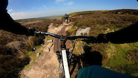
Best done as an out and back from either north or south this is a wild and fantastic route with both ways being just as fun. This is a hugely sensitive trail, stick to the path and avoid if it's wet. Best done in bone dry weather or maybe when the ground is iced frozen. There's no phone signal up there and is exposed with no trees or shelter so avoid in bad weather.

Please donate to help Peak District MTB fix the boggy sections: http://peakdistrictmtb.org/project/cut-gate/

Local Trail Association

Recent Activity on Trail

Past Week
  • 1 rides
  • 162.4 km average
6 Months
  • 9 rides
  • 50.8 km avg distance
All
  • 71 rides
  • Last: Jun 22, 2026
c1c2c3c4
January
February
March
April
May
June
July
August
September
October
November
December
update trails status or condition

Cutgate Trail Reports

statusdatedescription
Sep 9, 2024 @ 7:26am
Sep 9, 2024
Rode cut gate on 7th September and it rode well. Just a few small puddles here and there.
Apr 3, 2024 @ 1:36am
Apr 3, 2024
Jun 3, 2023 @ 2:08am
Jun 3, 2023
May 19, 2023 @ 10:35am
May 19, 2023
Great conditions
Apr 3, 2023 @ 4:41pm
Apr 3, 2023
more »
Status:
on Sep 9, 2024
Variable
Avg: 3.99 (10 votes)
Your vote: 0

view (1,118)
close
3D
Trail Conditions
  • Unknown
  • Snow Groomed
  • Snow Packed
  • Snow Covered
  • Snow Cover Partial
  • Freeze/thaw Cycle
  • Icy
  • Prevalent Mud
  • Wet
  • Variable
  • Ideal
  • Dry
  • Very Dry
Trail Flow (Ridden Direction)
Trailforks scans users ridelogs to determine the most popular direction each trail is ridden. A good flowing trail network will have most trails flowing in a single direction according to their intension.
The colour categories are based on what percentage of riders are riding a trail in its intended direction.
  • > 96%
  • > 90%
  • > 80%
  • > 70%
  • > 50%
  • < 50%
  • bi-directional trail
  • no data
Trail Last Ridden
Trailforks scans ridelogs to determine the last time a trail was ridden.
  • < 2 days
  • < 1 week
  • < 2 weeks
  • < 1 month
  • < 6 months
  • > 6 months
Trail Ridden Direction
The intended direction a trail should be ridden.
  • Downhill Only
  • Downhill Primary
  • Both Directions
  • Uphill Primary
  • Uphill Only
  • One Direction
Contribute Details
Colors indicate trail is missing specified detail.
  • Description
  • Photos
  • Description & Photos
  • Videos
Trail Popularity ?
Trailforks scans ridelogs to determine which trails are ridden the most in the last 9 months. Trails are compared with nearby trails in the same city region with a possible 25 colour shades. Think of this as a heatmap, more rides = more kinetic energy = warmer colors.
  • most popular
  • popular
  • less popular
  • not popular
ATV/ORV/OHV Filter
Max Vehicle Width
inches
US Cell Coverage
Legend
cell carrier legend

Radar Time
Activity Recordings
Trailforks uses anonymized public activity data. ?
Activity Recordings
Trailforks uses anonymized public activity data. ?
Personal Heatmap
Activity Types
all / none
Options
2
Date range month
Winter Trails
Warning A routing network for winter maps does not exist. Selecting trails using the winter trails layer has been disabled.
Missing Trails
Most Popular
Least Popular
Trails are colored based on popularity. The more popular a trail is, the more red. Less popular trails trend towards green.
Jump Magnitude Heatmap
Heatmap of where riders jump on trails. Zoom in to see individual jumps, click circles to view jump details.
BC Backroad Status

Service Road Atlas is a free to use, community-driven service for viewing and creating reports on the numerous back-country service roads around B.C. and Alberta.

map legend
Slope Aspect
Direction the slope faces
Flat N NE E SE S SW W NW
Trails Deemphasized
Trails are shown in grey.
disable
Only show trails with no bike usage.
Enable
Suggested Layers
Based on selected activity type

    Save the current map location and zoom level as your default home location whenever this page is loaded.

    Save
        Directions to cutgate trailhead (53.502423, -1.702859)

        Photos

        58 more »
        77 |
        Jun 19, 2025 @ 3:45am
        Jun 19, 2025
        138 |
        Feb 14, 2023 @ 8:13am
        Feb 14, 2023
        158 |
        Feb 14, 2023 @ 7:50am
        Feb 14, 2023
        399 |
        Feb 4, 2021 @ 3:32am
        Feb 4, 2021

        Videos

        5 more »
        Peak District MTB-Cut Gate
        455 | Aug 22, 2019 , Sheffield
        Cut Gate Path
        19:51 | 869 | Apr 16, 2019 , Sheffield
        Cutgate crash
        0:23 | 416 | Jun 2, 2021 , Sheffield
        Peaks - Cutgate/Hagg Side
        2:20 | 142 | Mar 12, 2019 , Sheffield

        Routes with this trail

        3.0 21 miles 2,268 ft 3
        Classic ‘hammer shaped’ route.

        3 Reviews & Comments


        We hope you've been enjoying Trailforks!

        Create a FREE account to view trail comments and much more.

        • By bigbluebikeTF Pro RS & contributors
        • #99207 - 15,047 views

        Frequently Asked Questions About Cutgate

        Where is Cutgate located?
        Cutgate is located in Peak District, Sheffield, United Kingdom. It is part of the Peak District trail network. The trailhead is located at coordinates 53.50242, -1.70286.
        How hard is Cutgate?
        Cutgate is rated as Red difficulty. The physical rating is Hard. The average grade is 0.3%.
        What is the elevation gain for Cutgate?
        Cutgate has 858 ft of elevation gain. The trail has 782 ft of elevation descent. The elevation ranges from 862 ft to 1,716 ft.
        Is Cutgate a point to point trail?
        Cutgate is not a point to point trail. The direction is Both Directions. The trail type is singletrack.

        Hit the Trail

        Open in App

        Get this trail on your phone instantly.
        open trail in app

        Download Trail

        Save to wishlist, Garmin & download.
        save the trail

        Find Related Routes

        Find routes and users activities that include this trail.
        find routes for this trail

        You must enter a description before submitting.