more stats
3.5 miles
Distance
161 ft
Climb
-138 ft
Descent
00:34:36
Avg time
24 ft
Altitude change
1,452 ft
Altitude min
1,514 ft
Altitude max
1,473 ft
Altitude start
1,496 ft
Altitude end
0.1%
Grade
-7.8%
Grade max
21.3%
Grade min
1 mile
Distance climb
1 mile
Distance down
4,833 ft
Distance flat
00:34:36
Avg time

Danky Dank Details

  • Activities
    • Mountain Bike
    • E-Bike
    • Hike
    • Trail Running
    • Snowshoe
  • Riding Area
    CAMBA Cable Cluster
    Cable, Wisconsin
  • Difficulty Rating
  • Local Popularity
    35 in Mountain Biking [+]
    • 5 in E-Biking
    • 5 in Trail Running
    • 5 in Hiking
    • 5 in Snowshoeing
  • Global Ranking
    #117395 in Mountain Biking [+]
    • #231853 in Hiking
  • Hiking SAC Scale
    T1 Hiking
  • Trail Type
    Singletrack
  • Snow Grooming
    Backcountry
  • Bike Type
    DH, AM, XC
  • Direction
    Both Directions
  • Climb Difficulty
    Blue
  • Physical Rating
    Hard
  • Trail Visibility
    Always easy to follow
  • Dogs Allowed
    Yes
  • eBike Allowed
  • Land Owner
    Bayfield County Forest

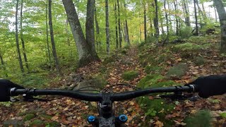
This remote piece of sweet singletrack is a trail that keeps on changing. With big flowy berms, expansive rock gardens, and multiple techy, steep B lines, this trail toes the line between a tricky blue and a solid black. Be prepared, as this trail is only accessible after a couple miles spent coming from the Esker Trail to the west or 3.5 miles on Treasures' Trace via Rock Lake from the east.

Local Trail Association

Recent Activity on Trail

Past Week
  • 0 rides
  •  
6 Months
  • 3 rides
  • 22 miles avg distance
All
  • 44 rides
  • Last: Jun 6, 2026
c1c2c3c4
January
February
March
April
May
June
July
August
September
October
November
December
update trails status or condition

Danky Dank Trail Reports

statusdatedescription
May 10, 2026 @ 6:16pm (America/Los_Angeles)
May 10, 2026
reporter Multiple large trees down across trail, blocking trail. Significant leaf and branch debris, needs clearing. N41 to N36, becomes worse as you ride...
May 10, 2026 @ 6:12pm (America/Los_Angeles)
May 10, 2026
reporter Multiple large trees down across trail, blocking trail. Entire section trailhead to N36 needs clearing
Oct 20, 2025 @ 12:25pm (America/Chicago)
Oct 20, 2025
reporter Logging in process
Oct 16, 2025 @ 12:47pm (America/Chicago)
Oct 16, 2025
Here is the location of the tree across the trail.
Oct 13, 2025 @ 12:24pm (America/Chicago)
Oct 13, 2025
more »
Status:
on May 10, 2026
Avg: 4.08 (7 votes)
Your vote: 0

view (318)
close
3D
Trail Conditions
  • Unknown
  • Snow Groomed
  • Snow Packed
  • Snow Covered
  • Snow Cover Partial
  • Freeze/thaw Cycle
  • Icy
  • Prevalent Mud
  • Wet
  • Variable
  • Ideal
  • Dry
  • Very Dry
Trail Flow (Ridden Direction)
Trailforks scans users ridelogs to determine the most popular direction each trail is ridden. A good flowing trail network will have most trails flowing in a single direction according to their intension.
The colour categories are based on what percentage of riders are riding a trail in its intended direction.
  • > 96%
  • > 90%
  • > 80%
  • > 70%
  • > 50%
  • < 50%
  • bi-directional trail
  • no data
Trail Last Ridden
Trailforks scans ridelogs to determine the last time a trail was ridden.
  • < 2 days
  • < 1 week
  • < 2 weeks
  • < 1 month
  • < 6 months
  • > 6 months
Trail Ridden Direction
The intended direction a trail should be ridden.
  • Downhill Only
  • Downhill Primary
  • Both Directions
  • Uphill Primary
  • Uphill Only
  • One Direction
Contribute Details
Colors indicate trail is missing specified detail.
  • Description
  • Photos
  • Description & Photos
  • Videos
Trail Popularity ?
Trailforks scans ridelogs to determine which trails are ridden the most in the last 9 months. Trails are compared with nearby trails in the same city region with a possible 25 colour shades. Think of this as a heatmap, more rides = more kinetic energy = warmer colors.
  • most popular
  • popular
  • less popular
  • not popular
ATV/ORV/OHV Filter
Max Vehicle Width
inches
US Cell Coverage
Legend
cell carrier legend

Radar Time
Activity Recordings
Trailforks uses anonymized public activity data. ?
Activity Recordings
Trailforks uses anonymized public activity data. ?
Personal Heatmap
Activity Types
all / none
Options
2
Date range month
Winter Trails
Warning A routing network for winter maps does not exist. Selecting trails using the winter trails layer has been disabled.
Missing Trails
Most Popular
Least Popular
Trails are colored based on popularity. The more popular a trail is, the more red. Less popular trails trend towards green.
Jump Magnitude Heatmap
Heatmap of where riders jump on trails. Zoom in to see individual jumps, click circles to view jump details.
BC Backroad Status

Service Road Atlas is a free to use, community-driven service for viewing and creating reports on the numerous back-country service roads around B.C. and Alberta.

map legend
Slope Aspect
Direction the slope faces
Flat N NE E SE S SW W NW
Trails Deemphasized
Trails are shown in grey.
disable
Only show trails with no bike usage.
Enable
Suggested Layers
Based on selected activity type

    Save the current map location and zoom level as your default home location whenever this page is loaded.

    Save
        Directions to danky-dank trailhead (46.176530, -91.211460)

        Photos

        10 more »
        235 |
        May 18, 2021 @ 10:01am
        May 18, 2021
        236 |
        May 18, 2021 @ 10:01am
        May 18, 2021
        229 |
        May 18, 2021 @ 10:01am
        May 18, 2021
        24 |
        May 10, 2026 @ 6:20pm
        May 10, 2026

        Videos

        1 more »
        Getting Lost in the Gnar on Danky Dank
        25:08 | 53 | Sep 21, 2025 , Cable

        Routes with this trail

        64 miles 4,689 ft 9
        2023 68 mile course - CAMBA is back in 2023 with one of the midwest’s most iconic mountain bike...
        51 miles 3,609 ft 10 Loop
        This is an expanded version of the IMBA Epic Rock Lake Loop to include trails to the west such as Dirt...
        43 miles 2,663 ft 13 Loop
        Super great route, all singletrack. Enjoy!

        2 Reviews & Comments


        We hope you've been enjoying Trailforks!

        Create a FREE account to view trail comments and much more.

        • By teleturn2TF Pro & contributors
        • #52982 - 2,848 views

        Frequently Asked Questions About Danky Dank

        Where is Danky Dank located?
        Danky Dank is located in CAMBA Cable Cluster, Cable, Wisconsin, United States. It is part of the CAMBA Cable Cluster trail network. The trailhead is located at coordinates 46.17653, -91.21146.
        How hard is Danky Dank?
        Danky Dank is rated as Black Diamond difficulty. The physical rating is Hard. The average grade is 0.1%. The climb difficulty is rated Blue.
        What is the elevation gain for Danky Dank?
        Danky Dank has 161 ft of elevation gain. The trail has 138 ft of elevation descent. The elevation ranges from 1,452 ft to 1,514 ft.
        Is Danky Dank a point to point trail?
        Danky Dank is not a point to point trail. The direction is Both Directions. The trail type is singletrack.

        Hit the Trail

        Open in App

        Get this trail on your phone instantly.
        open trail in app

        Download Trail

        Save to wishlist, Garmin & download.
        save the trail

        Find Related Routes

        Find routes and users activities that include this trail.
        find routes for this trail

        You must enter a description before submitting.