more stats
1,020 ft
Distance
-486 ft
Descent
00:11:35
Avg time
-486 ft
Altitude change
5,836 ft
Altitude min
6,322 ft
Altitude max
6,322 ft
Altitude start
5,837 ft
Altitude end
-47.6%
Grade
-81.2%
Grade max
-11%
Grade min
1,020 ft
Distance down
00:11:35
Avg time

Dead Dog Details

  • Activities
    • Mountain Bike
    • E-Bike
  • Riding Area
    Mount 7
    Golden, British Columbia
  • Difficulty Rating
  • Voted Difficulty
    Proline (6 votes)
  • Local Popularity
    40 in Mountain Biking [+]
    • 20 in E-Biking
  • Global Ranking
    #94379 in Mountain Biking [+]
    • #90269 in E-Biking
  • Trail Type
    Singletrack
  • Bike Type
    DH
  • Direction
    Downhill Only
    Popular Direction Shown
  • eBike Allowed

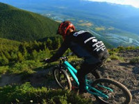
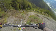
This trail is not for the faint of heart, or inexperienced rider. It begins with a shale entrance that should be taken slowly as it is very easy to pickup unwanted speed. It is a loose section that can make for some great controlled brake-carves. There is a good meeting point at the end of the shale to wait for any friends that are joining. Although the rest of the trail ahead is not shale, it does get steeper (yes, steeper) once you enter the trees. It’s recommended that you give each rider a fair lead before following, as it is very difficult to restart the descent once you have come to a complete stop on the slope. Also loose rocks are often dislodged while descending, and sent towards any rider below you.

The trail is not regularly maintained, and due to its aggressive pitch there is often deep ruts from erosion, exposed roots, and rock. There are a few catch berms to slow you down during the run, but expect to be using your brakes for the duration of the ride.

Trail Supporters
Local Trail Association
Traditionally Indigenous Territory

Recent Activity on Trail

Past Week
  • 2 rides
  • 57 miles average
6 Months
  • 8 rides
  • 19 miles avg distance
All
  • 66 rides
  • Last: Jun 24, 2026
c1c2c3c4
January
February
March
April
May
June
July
August
September
October
November
December
update trails status or condition

Dead Dog Trail Reports

statusdatedescription
May 20, 2026 @ 11:31am (America/Edmonton)
May 20, 2026
Mar 30, 2026 @ 8:01pm (America/Edmonton)
Mar 30, 2026
reporter The trail crew will open trails as they are assessed. Thanks.
Jun 25, 2025 @ 5:21pm
Jun 25, 2025
Upper Part Perfect, but greasy later
May 25, 2025 @ 5:42pm
May 25, 2025
reporter
May 17, 2025 @ 4:01pm
May 17, 2025
more »
Status:
on May 20, 2026
Ideal
Avg: 4.45 (15 votes)
Your vote: 0

view (565)
close
3D
Trail Conditions
  • Unknown
  • Snow Groomed
  • Snow Packed
  • Snow Covered
  • Snow Cover Partial
  • Freeze/thaw Cycle
  • Icy
  • Prevalent Mud
  • Wet
  • Variable
  • Ideal
  • Dry
  • Very Dry
Trail Flow (Ridden Direction)
Trailforks scans users ridelogs to determine the most popular direction each trail is ridden. A good flowing trail network will have most trails flowing in a single direction according to their intension.
The colour categories are based on what percentage of riders are riding a trail in its intended direction.
  • > 96%
  • > 90%
  • > 80%
  • > 70%
  • > 50%
  • < 50%
  • bi-directional trail
  • no data
Trail Last Ridden
Trailforks scans ridelogs to determine the last time a trail was ridden.
  • < 2 days
  • < 1 week
  • < 2 weeks
  • < 1 month
  • < 6 months
  • > 6 months
Trail Ridden Direction
The intended direction a trail should be ridden.
  • Downhill Only
  • Downhill Primary
  • Both Directions
  • Uphill Primary
  • Uphill Only
  • One Direction
Contribute Details
Colors indicate trail is missing specified detail.
  • Description
  • Photos
  • Description & Photos
  • Videos
Trail Popularity ?
Trailforks scans ridelogs to determine which trails are ridden the most in the last 9 months. Trails are compared with nearby trails in the same city region with a possible 25 colour shades. Think of this as a heatmap, more rides = more kinetic energy = warmer colors.
  • most popular
  • popular
  • less popular
  • not popular
ATV/ORV/OHV Filter
Max Vehicle Width
inches
US Cell Coverage
Legend
cell carrier legend

Radar Time
Activity Recordings
Trailforks uses anonymized public activity data. ?
Activity Recordings
Trailforks uses anonymized public activity data. ?
Personal Heatmap
Activity Types
all / none
Options
2
Date range month
Winter Trails
Warning A routing network for winter maps does not exist. Selecting trails using the winter trails layer has been disabled.
Missing Trails
Most Popular
Least Popular
Trails are colored based on popularity. The more popular a trail is, the more red. Less popular trails trend towards green.
Jump Magnitude Heatmap
Heatmap of where riders jump on trails. Zoom in to see individual jumps, click circles to view jump details.
BC Backroad Status

Service Road Atlas is a free to use, community-driven service for viewing and creating reports on the numerous back-country service roads around B.C. and Alberta.

map legend
Slope Aspect
Direction the slope faces
Flat N NE E SE S SW W NW
Trails Deemphasized
Trails are shown in grey.
disable
Only show trails with no bike usage.
Enable
Suggested Layers
Based on selected activity type

    Save the current map location and zoom level as your default home location whenever this page is loaded.

    Save
        Directions to dead-dog trailhead (51.275480, -116.885330)

        Photos

        78 more »
        830 |
        Jul 20, 2022 @ 11:01pm
        Jul 20, 2022
        960 |
        Jul 20, 2022 @ 11:01pm
        Jul 20, 2022
        238 |
        Sep 30, 2021 @ 8:37pm
        Sep 30, 2021
        830 |
        Aug 5, 2020 @ 9:40pm
        Aug 5, 2020

        Videos

        8 more »
        youtuber This is the Steepest Bike Trail in the World...
        19:37 | 1420 | Aug 16, 2021 , Golden
        youtuber Riding the STEEPEST Trail in Canada.. (my...
        14:19 | 1036 | Sep 24, 2020 , Golden
        youtuber This Trail Was Way Beyond My Skill Level!
        11:20 | 850 | Sep 24, 2020 , Golden
        dead dog
        2:33 | 727 | Jun 7, 2020 , Golden

        Trail Lists

        Routes with this trail

        4 miles 103 ft 5 Race
        The Classic! Steep and gnarly!

        7 Reviews & Comments


        We hope you've been enjoying Trailforks!

        Create a FREE account to view trail comments and much more.

        Nearby Trails

        • By canadakaTF Pro Trailforks & contributors
        • #3457 - 18,831 views

        Frequently Asked Questions About Dead Dog

        Where is Dead Dog located?
        Dead Dog is located in Mount 7, Golden, British Columbia, Canada. It is part of the Mount 7 trail network. The trailhead is located at coordinates 51.27548, -116.88533.
        How hard is Dead Dog?
        Dead Dog is rated as Double Black Diamond difficulty. The average grade is 47.6%.
        What is the elevation gain for Dead Dog?
        The trail has 486 ft of elevation descent. The elevation ranges from 5,836 ft to 6,322 ft.
        Is Dead Dog a point to point trail?
        Yes, Dead Dog is a point to point trail. The direction is Downhill Only. The trail type is singletrack.

        Hit the Trail

        Open in App

        Get this trail on your phone instantly.
        open trail in app

        Download Trail

        Save to wishlist, Garmin & download.
        save the trail

        Find Related Routes

        Find routes and users activities that include this trail.
        find routes for this trail

        You must enter a description before submitting.