more stats
4.4 miles
Distance
16 ft
Climb
-2,264 ft
Descent
00:46:43
Avg time
-2,247 ft
Altitude change
1,844 ft
Altitude min
4,092 ft
Altitude max
4,092 ft
Altitude start
1,844 ft
Altitude end
-9.6%
Grade
-76%
Grade max
8.2%
Grade min
394 ft
Distance climb
4 miles
Distance down
591 ft
Distance flat
00:46:43
Avg time

Deathstar (#1025) Details

  • Activities
    • Mountain Bike
    • Hike
    • Trail Running
  • Riding Area
    Hone Quarry - GWNF
    Harrisonburg, Virginia
  • Difficulty Rating
  • Voted Difficulty
    Black Diamond (1 vote)
  • Local Popularity
    45 in Mountain Biking [+]
    • 5 in Trail Running
    • 50 in Hiking
  • Global Ranking
    #58189 in Mountain Biking [+]
    • #107089 in Hiking
  • Trail Type
    Singletrack
  • Bike Type
    DH, AM
  • Direction
    Downhill Primary
    Popular Direction Shown
  • Dogs Allowed
    Yes
  • Land Owner
    US Forest Service

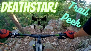
Sometimes referred to as "Sugar Run" or known locally as "Deathstar", this is a fast, fun, raw, and un-groomed trail in the GWNF. There are a two main rock obstacles, the first is easier than the second. There is also some super-fast downhill towards the end, be careful when leaves are down as you'll feel like you're ice skating.

The "Deathstar" name comes from the fact that you can see a multitude of satellite dishes on the NSA base in the distance to the west. Regardless of what you call it, it's super-fun, fast and flowing. As previously stated, it becomes very steep at one section towards the conclusion of the downhill.

Trail Supporters

  • USFS
    Land Manager
Traditionally Indigenous Territory

Recent Activity on Trail

Past Week
  • 0 rides
  •  
6 Months
  • 6 rides
  • 11 miles avg distance
All
  • 24 rides
  • Last: Jun 7, 2026
c1c2c3c4
January
February
March
April
May
June
July
August
September
October
November
December
update trails status or condition

Deathstar (#1025) Trail Reports

statusdatedescription
Mar 12, 2025 @ 3:37pm
Mar 12, 2025
Chainsawed top to bottom. Running really clear now. Cut 4-5 significant sized trees and a few extras
Mar 3, 2025 @ 4:31pm
Mar 3, 2025
The access road at the end of the trail now has posted signs. Not sure what the deal is. Not sure if it is lawfully posted private property of what…
Oct 6, 2024 @ 10:59am
Oct 6, 2024
Several trees down along this route
Mar 19, 2024 @ 8:52am
Mar 19, 2024
Sawed top to bottom
Nov 6, 2023 @ 5:05am
Nov 6, 2023
This is late report to document trail work back in the spring. I'm trying to keep everything here. We brushed and sawed from top to bottom.
more »
Status:
on Mar 12, 2025
Dry
Avg: 3.86 (2 votes)
Your vote: 0

view (223)
close
3D
Trail Conditions
  • Unknown
  • Snow Groomed
  • Snow Packed
  • Snow Covered
  • Snow Cover Partial
  • Freeze/thaw Cycle
  • Icy
  • Prevalent Mud
  • Wet
  • Variable
  • Ideal
  • Dry
  • Very Dry
Trail Flow (Ridden Direction)
Trailforks scans users ridelogs to determine the most popular direction each trail is ridden. A good flowing trail network will have most trails flowing in a single direction according to their intension.
The colour categories are based on what percentage of riders are riding a trail in its intended direction.
  • > 96%
  • > 90%
  • > 80%
  • > 70%
  • > 50%
  • < 50%
  • bi-directional trail
  • no data
Trail Last Ridden
Trailforks scans ridelogs to determine the last time a trail was ridden.
  • < 2 days
  • < 1 week
  • < 2 weeks
  • < 1 month
  • < 6 months
  • > 6 months
Trail Ridden Direction
The intended direction a trail should be ridden.
  • Downhill Only
  • Downhill Primary
  • Both Directions
  • Uphill Primary
  • Uphill Only
  • One Direction
Contribute Details
Colors indicate trail is missing specified detail.
  • Description
  • Photos
  • Description & Photos
  • Videos
Trail Popularity ?
Trailforks scans ridelogs to determine which trails are ridden the most in the last 9 months. Trails are compared with nearby trails in the same city region with a possible 25 colour shades. Think of this as a heatmap, more rides = more kinetic energy = warmer colors.
  • most popular
  • popular
  • less popular
  • not popular
ATV/ORV/OHV Filter
Max Vehicle Width
inches
US Cell Coverage
Legend
cell carrier legend

Radar Time
Activity Recordings
Trailforks uses anonymized public activity data. ?
Activity Recordings
Trailforks uses anonymized public activity data. ?
Personal Heatmap
Activity Types
all / none
Options
2
Date range month
Winter Trails
Warning A routing network for winter maps does not exist. Selecting trails using the winter trails layer has been disabled.
Missing Trails
Most Popular
Least Popular
Trails are colored based on popularity. The more popular a trail is, the more red. Less popular trails trend towards green.
Jump Magnitude Heatmap
Heatmap of where riders jump on trails. Zoom in to see individual jumps, click circles to view jump details.
BC Backroad Status

Service Road Atlas is a free to use, community-driven service for viewing and creating reports on the numerous back-country service roads around B.C. and Alberta.

map legend
Slope Aspect
Direction the slope faces
Flat N NE E SE S SW W NW
Trails Deemphasized
Trails are shown in grey.
disable
Only show trails with no bike usage.
Enable
Suggested Layers
Based on selected activity type

    Save the current map location and zoom level as your default home location whenever this page is loaded.

    Save
        Directions to deathstar--1025 trailhead (38.507920, -79.213950)

        Photos

        2 more »
        172 |
        Sep 18, 2022 @ 4:26pm
        Sep 18, 2022
        575 |
        Apr 15, 2019 @ 5:55pm
        Apr 15, 2019

        Videos

        2 more »
        Deathstar (Sugar Run) Trail Peek | George...
        15:47 | 1104 | Sep 5, 2021 , Harrisonburg
        0:06 | 673 | Apr 15, 2019 , Harrisonburg

        2 Reviews & Comments


        We hope you've been enjoying Trailforks!

        Create a FREE account to view trail comments and much more.

        • By jackdichiara2013 & contributors
        • #91947 - 4,975 views

        Frequently Asked Questions About Deathstar (#1025)

        Where is Deathstar (#1025) located?
        Deathstar (#1025) is located in Hone Quarry - GWNF, Harrisonburg, Virginia, United States. It is part of the Hone Quarry - GWNF trail network. The trailhead is located at coordinates 38.50792, -79.21395.
        How hard is Deathstar (#1025)?
        Deathstar (#1025) is rated as Double Black Diamond difficulty. The average grade is 9.6%.
        What is the elevation gain for Deathstar (#1025)?
        Deathstar (#1025) has 16 ft of elevation gain. The trail has 2,264 ft of elevation descent. The elevation ranges from 1,844 ft to 4,092 ft.
        Is Deathstar (#1025) a point to point trail?
        Deathstar (#1025) is not a point to point trail. The direction is Downhill Primary. The trail type is singletrack.

        Hit the Trail

        Open in App

        Get this trail on your phone instantly.
        open trail in app

        Download Trail

        Save to wishlist, Garmin & download.
        save the trail

        Find Related Routes

        Find routes and users activities that include this trail.
        find routes for this trail

        You must enter a description before submitting.