more stats
1,762 ft
Distance
-206 ft
Descent
2,323 ft
High Point
-206 ft
Altitude change
2,117 ft
Altitude min
2,323 ft
Altitude start
2,116 ft
Altitude end
-11.7%
Grade
-26.8%
Grade max
-1.5%
Grade min
1,762 ft
Distance down

Deep Forest Details

  • Activities
    • Mountain Bike
    • E-Bike
    • Hike
    • Trail Running
  • Riding Area
    Bike Park Evolution
    East Sarajevo
  • Difficulty Rating
  • Voted Difficulty
    Black Diamond (1 vote)
  • Local Popularity
    80 in Mountain Biking [+]
    • 75 in E-Biking
    • 5 in Trail Running
    • 90 in Hiking
  • Global Ranking
    #9472 in Mountain Biking [+]
    • #29074 in E-Biking
    • #197095 in Trail Running
    • #42225 in Hiking
  • Trail Exposure
    High Risk
  • Trail Type
    Singletrack
  • Bike Type
    DH, AM
  • Direction
    Downhill Primary[+]
    Popular Direction Shown
    • Downhill Primary for E-Biking
    • Downhill Primary for Trail Running
    • Downhill Primary for Hiking
  • Climb Difficulty
    Blue
  • Physical Rating
    Moderate
  • Trail Visibility
    Sometimes hard to follow
  • Dogs Allowed
    Yes
  • eBike Allowed
  • Lighting
    No
  • Year Opened
    2025
  • Land Owner
  • OSM Way

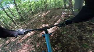
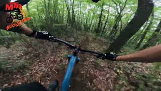
Staza Deep Forest je nastala 2024. godine, kao deo ambicioznog projekta MTB Evolution tima u okviru Bike Parka Evolution. Tokom prvobitne faze izgradnje, trasa je više puta prilagođavana kako bi pružila najbolje moguće iskustvo vožnje.

U početku, deo ove staze pratio je drugačiju putanju, ali je kasnije taj segment postao deo staze Roller Coaster, dok je nova verzija Deep Foresta dobila unapređenu konfiguraciju sa dodatnim tehničkim elementima.

Cilj ovog redizajna bio je stvoriti dinamičnu, brzu i tehnički zahtevnu stazu, koja će vozačima ponuditi pravi test sposobnosti, ali i dozu adrenalina uz svaki zavoj.

Trail Supporters

Bike Park

Local Trail Association

Recent Activity on Trail

Past Week
  • 0 rides
  •  
6 Months
  • 0 rides
  •  
All
  • 37 rides
  • Last: Nov 5, 2025
c1c2c3c4
January
February
March
April
May
June
July
August
September
October
November
December
Status:
on Feb 8, 2026
Variable
Avg: 4.13 (1 votes)
Your vote: 0

view (87)
close
3D
Trail Conditions
  • Unknown
  • Snow Groomed
  • Snow Packed
  • Snow Covered
  • Snow Cover Partial
  • Freeze/thaw Cycle
  • Icy
  • Prevalent Mud
  • Wet
  • Variable
  • Ideal
  • Dry
  • Very Dry
Trail Flow (Ridden Direction)
Trailforks scans users ridelogs to determine the most popular direction each trail is ridden. A good flowing trail network will have most trails flowing in a single direction according to their intension.
The colour categories are based on what percentage of riders are riding a trail in its intended direction.
  • > 96%
  • > 90%
  • > 80%
  • > 70%
  • > 50%
  • < 50%
  • bi-directional trail
  • no data
Trail Last Ridden
Trailforks scans ridelogs to determine the last time a trail was ridden.
  • < 2 days
  • < 1 week
  • < 2 weeks
  • < 1 month
  • < 6 months
  • > 6 months
Trail Ridden Direction
The intended direction a trail should be ridden.
  • Downhill Only
  • Downhill Primary
  • Both Directions
  • Uphill Primary
  • Uphill Only
  • One Direction
Contribute Details
Colors indicate trail is missing specified detail.
  • Description
  • Photos
  • Description & Photos
  • Videos
Trail Popularity ?
Trailforks scans ridelogs to determine which trails are ridden the most in the last 9 months. Trails are compared with nearby trails in the same city region with a possible 25 colour shades. Think of this as a heatmap, more rides = more kinetic energy = warmer colors.
  • most popular
  • popular
  • less popular
  • not popular
ATV/ORV/OHV Filter
Max Vehicle Width
inches
US Cell Coverage
Legend
cell carrier legend

Radar Time
Activity Recordings
Trailforks uses anonymized public activity data. ?
Activity Recordings
Trailforks uses anonymized public activity data. ?
Personal Heatmap
Activity Types
all / none
Options
2
Date range month
Winter Trails
Warning A routing network for winter maps does not exist. Selecting trails using the winter trails layer has been disabled.
Missing Trails
Most Popular
Least Popular
Trails are colored based on popularity. The more popular a trail is, the more red. Less popular trails trend towards green.
Jump Magnitude Heatmap
Heatmap of where riders jump on trails. Zoom in to see individual jumps, click circles to view jump details.
BC Backroad Status

Service Road Atlas is a free to use, community-driven service for viewing and creating reports on the numerous back-country service roads around B.C. and Alberta.

map legend
Slope Aspect
Direction the slope faces
Flat N NE E SE S SW W NW
Trails Deemphasized
Trails are shown in grey.
disable
Only show trails with no bike usage.
Enable
Suggested Layers
Based on selected activity type

    Save the current map location and zoom level as your default home location whenever this page is loaded.

    Save
        Directions to deep-forest-746858 trailhead (43.787140, 18.366840)

        Photos

        3 more »
        53 |
        May 18, 2024 @ 7:15am
        May 18, 2024
        30 |
        May 16, 2024 @ 1:26pm
        May 16, 2024
        36 |
        May 16, 2024 @ 1:26pm
        May 16, 2024
        43 |
        May 18, 2024 @ 7:24am
        May 18, 2024

        Videos

        3 more »
        Izgubljen u zelenilu: Adrenalinska avantura na...
        2:19 | 78 | Oct 2, 2024 , East Sarajevo
        Deep Forest trail - Bike park Evolution
        2:08 | 102 | Jun 7, 2024 , East Sarajevo
        Premijerno Deep Forest - MTB Evolution
        2:22 | 78 | May 27, 2024 , East Sarajevo

        Routes with this trail

        1 mile 39 ft 8 Point to Point
        Stage 2: * Dužina: 2 km * Ukupna elevacija: oko 200 m * Staze: i Opis rute: Stage 2 enduro utrke u...

        Links

        Reviews / Comments

        No reviews yet, be the first to write a review or ask a question.
        Use trail reports to comment on trail conditions.


        We hope you've been enjoying Trailforks!

        Create a FREE account to view trail comments and much more.

        Frequently Asked Questions About Deep Forest

        Where is Deep Forest located?
        Deep Forest is located in Bike Park Evolution, East Sarajevo, Bosnia and Herzegovina. It is part of the Bike Park Evolution trail network. The trailhead is located at coordinates 43.78714, 18.36684.
        How hard is Deep Forest?
        Deep Forest is rated as Black Diamond difficulty. The physical rating is Moderate. The average grade is 11.7%. The climb difficulty is rated Blue.
        What is the elevation gain for Deep Forest?
        The trail has 206 ft of elevation descent. The elevation ranges from 2,117 ft to 2,323 ft.
        Is Deep Forest a point to point trail?
        Deep Forest is not a point to point trail. The direction is Downhill Primary. The trail type is singletrack.

        Hit the Trail

        Open in App

        Get this trail on your phone instantly.
        open trail in app

        Download Trail

        Save to wishlist, Garmin & download.
        save the trail

        Find Related Routes

        Find routes and users activities that include this trail.
        find routes for this trail

        You must enter a description before submitting.