more stats
4,367 ft
Distance
6 ft
Climb
-487 ft
Descent
00:10:19
Avg time
-481 ft
Altitude change
2,101 ft
Altitude min
2,581 ft
Altitude max
2,581 ft
Altitude start
2,100 ft
Altitude end
-11%
Grade
-39.9%
Grade max
6.3%
Grade min
184 ft
Distance climb
3,911 ft
Distance down
269 ft
Distance flat
00:10:19
Avg time

Deep Thought Details

  • Activities
    • Mountain Bike
    • E-Bike
    • Winter Fat Bike
  • Riding Area
    Beacon Hill
    Spokane, Washington
  • Difficulty Rating
  • Voted Difficulty
    Black Diamond (4 votes)
  • Local Popularity
    90 in Mountain Biking [+]
    • 80 in E-Biking
  • Global Ranking
    #44180 in Mountain Biking [+]
    • #32262 in E-Biking
  • Trail Type
    Singletrack
  • Bike Type
    DH, AM, Fat
  • Direction
    Downhill Only
    Popular Direction Shown
  • Physical Rating
    Moderate
  • Trail Visibility
    Always easy to follow
  • eBike Allowed
    Yes up to Class 1
  • TTFs on Trail
    Berm, Drop, Jump, Rock Face, Rock Garden, Wallride
  • Year Opened
    2018

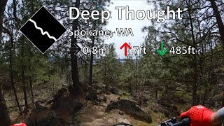
Deep Thought is a technical descending trail that flows through rock gardens and single track. there are many blind rollers, please look before riding sections. There are two drops, not huck to flats, they have landings and are meant to hit with some speed.

Access Info

The entrance is about 70ft to the south west of the top of upchuck.

Disclaimer

Look at obstacles before attempting them.

Trail Supporters

  • Tim Schlosser
    Builder
  • Alexey Florianovich
    Builder
  • Jake Buell
    Builder
Traditionally Indigenous Territory

Recent Activity on Trail

Past Week
  • 2 rides
  • 6 miles average
6 Months
  • 76 rides
  • 11 miles avg distance
All
  • 527 rides
  • Last: Jun 4, 2026
c1c2c3c4
January
February
March
April
May
June
July
August
September
October
November
December
Status:
on May 6, 2026
Dry
Avg: 4.2 (15 votes)
Your vote: 0

view (3,551)
close
3D
Trail Conditions
  • Unknown
  • Snow Groomed
  • Snow Packed
  • Snow Covered
  • Snow Cover Partial
  • Freeze/thaw Cycle
  • Icy
  • Prevalent Mud
  • Wet
  • Variable
  • Ideal
  • Dry
  • Very Dry
Trail Flow (Ridden Direction)
Trailforks scans users ridelogs to determine the most popular direction each trail is ridden. A good flowing trail network will have most trails flowing in a single direction according to their intension.
The colour categories are based on what percentage of riders are riding a trail in its intended direction.
  • > 96%
  • > 90%
  • > 80%
  • > 70%
  • > 50%
  • < 50%
  • bi-directional trail
  • no data
Trail Last Ridden
Trailforks scans ridelogs to determine the last time a trail was ridden.
  • < 2 days
  • < 1 week
  • < 2 weeks
  • < 1 month
  • < 6 months
  • > 6 months
Trail Ridden Direction
The intended direction a trail should be ridden.
  • Downhill Only
  • Downhill Primary
  • Both Directions
  • Uphill Primary
  • Uphill Only
  • One Direction
Contribute Details
Colors indicate trail is missing specified detail.
  • Description
  • Photos
  • Description & Photos
  • Videos
Trail Popularity ?
Trailforks scans ridelogs to determine which trails are ridden the most in the last 9 months. Trails are compared with nearby trails in the same city region with a possible 25 colour shades. Think of this as a heatmap, more rides = more kinetic energy = warmer colors.
  • most popular
  • popular
  • less popular
  • not popular
ATV/ORV/OHV Filter
Max Vehicle Width
inches
US Cell Coverage
Legend
cell carrier legend

Radar Time
Activity Recordings
Trailforks uses anonymized public activity data. ?
Activity Recordings
Trailforks uses anonymized public activity data. ?
Personal Heatmap
Activity Types
all / none
Options
2
Date range month
Winter Trails
Warning A routing network for winter maps does not exist. Selecting trails using the winter trails layer has been disabled.
Missing Trails
Most Popular
Least Popular
Trails are colored based on popularity. The more popular a trail is, the more red. Less popular trails trend towards green.
Jump Magnitude Heatmap
Heatmap of where riders jump on trails. Zoom in to see individual jumps, click circles to view jump details.
BC Backroad Status

Service Road Atlas is a free to use, community-driven service for viewing and creating reports on the numerous back-country service roads around B.C. and Alberta.

map legend
Slope Aspect
Direction the slope faces
Flat N NE E SE S SW W NW
Trails Deemphasized
Trails are shown in grey.
disable
Only show trails with no bike usage.
Enable
Suggested Layers
Based on selected activity type

    Save the current map location and zoom level as your default home location whenever this page is loaded.

    Save
        Directions to deep-thought trailhead (47.693700, -117.334640)

        Photos

        45 more »
        61 |
        Oct 5, 2025 @ 8:07am
        Oct 5, 2025
        70 |
        Oct 5, 2025 @ 8:07am
        Oct 5, 2025
        59 |
        Oct 5, 2025 @ 8:04am
        Oct 5, 2025
        66 |
        Oct 5, 2025 @ 8:03am
        Oct 5, 2025

        Videos

        7 more »
        youtuber Deep Thought - Beacon Hill - Spokane, WA
        8:47 | 392 | Apr 16, 2023 , Spokane
        youtuber  Deep Thought trail at Beacon Hill Bike Park/...
        9:31 | 1045 | Oct 22, 2020 , Spokane
        Deep Thought - Beacon Hill - Spokane, WA
        7:00 | 243 | Sep 25, 2024 , Spokane
        Riding Spokane.
        4:05 | 190 | Aug 6, 2023 , Spokane

        Trail Lists

        Routes with this trail

        5.0 4,206 ft 7 ft 8
        2020 Hubaplooza Stage 3 - all categories
        10 miles 1,755 ft 12 Loop Race
        Expected Route for 2022 hubapalooza - might be some changes to the course.

        3 Reviews & Comments


        We hope you've been enjoying Trailforks!

        Create a FREE account to view trail comments and much more.

        • By TimRidesBikesTF Pro & contributors
        • #158929 - 6,223 views

        Frequently Asked Questions About Deep Thought

        Where is Deep Thought located?
        Deep Thought is located in Beacon Hill, Spokane, Washington, United States. It is part of the Beacon Hill trail network. The trailhead is located at coordinates 47.6937, -117.33464.
        How hard is Deep Thought?
        Deep Thought is rated as Black Diamond difficulty. The physical rating is Moderate. The average grade is 11%.
        What is the elevation gain for Deep Thought?
        Deep Thought has 6 ft of elevation gain. The trail has 487 ft of elevation descent. The elevation ranges from 2,101 ft to 2,581 ft.
        Is Deep Thought a point to point trail?
        Yes, Deep Thought is a point to point trail. The direction is Downhill Only. The trail type is singletrack.

        Hit the Trail

        Open in App

        Get this trail on your phone instantly.
        open trail in app

        Download Trail

        Save to wishlist, Garmin & download.
        save the trail

        Find Related Routes

        Find routes and users activities that include this trail.
        find routes for this trail

        You must enter a description before submitting.