
Open in App
Get this trail on your phone instantly.

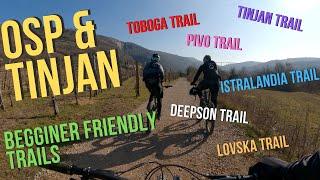
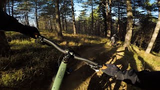
New trail in the Bagnoli-Dolina region. Shares the access trail and the start with Toboga, there is a clear path on the left as it starts. The real Enduro trail with some really steep sections, slow steep switchbacks and loads of counterslopes in the loamy soil. The trail can be divided in 3 sections. The first is from the start to the paved road that you probability did to get to go Prebenico, not very steep, almost easy. The second part is the hardest, it goes from the road to a fire road. It is steep, has a lot of counterslopes and sections that are better to know before hit the trail in a row. The third part goes from this fire road, as you get it you turn left and after 1 meter turn right down another fire road, ride it for 10 meters and there is a path on the grass on your right. This section goes in a natural gully, few times in and out the little river in it with the last part being a flat out fast section with little gradient to the finish.
AT THE VERY FINISH OF THE TRAIL THERE IS A DROP FROM THE TRAIL TO THE GRAVEL ROAD. PAY ATTENTION TO VEHICLES AND THE DROP ITSELF.
Shares the access and the start with Toboga trail.
| c1 | c2 | c3 | c4 |
|---|---|---|---|
January | February | March | April |
May | June | July | August |
September | October | November | December |

Service Road Atlas is a free to use, community-driven service for viewing and creating reports on the numerous back-country service roads around B.C. and Alberta.
Save the current map location and zoom level as your default home location whenever this page is loaded.
SaveWe hope you've been enjoying Trailforks!
Create a FREE account to view trail comments and much more.
You must enter a description before submitting.

