more stats
6.3 miles
Distance
2,165 ft
Climb
-2,391 ft
Descent
04:42:52
Avg time
-227 ft
Altitude change
5,278 ft
Altitude min
7,649 ft
Altitude max
5,505 ft
Altitude start
5,279 ft
Altitude end
-0.7%
Grade
-51.5%
Grade max
43.3%
Grade min
3 miles
Distance climb
3 miles
Distance down
650 ft
Distance flat
04:42:52
Avg time

Deer Pass Trail Details

  • Activities
    • Mountain Bike
    • Horse
    • Hike
    • Trail Running
  • Riding Area
    South Chilcotin Mountains Provincial Park
    Gold Bridge, British Columbia
  • Difficulty Rating
  • Global Ranking
    #126366 in Mountain Biking [+]
    • #136759 in Trail Running
    • #130062 in Hiking
    • #1752 in Horseback
  • Trail Type
    Wilderness Trail
  • Bike Type
    AM, XC
  • Direction
    Both Directions
    Popular Direction Shown
  • Climb Difficulty
    Black Diamond
  • Physical Rating
    Extreme
  • Dogs Allowed
    Yes
  • eBike Allowed
  • Land Owner

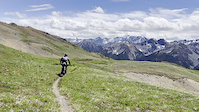
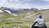
As with all BC Parks trails, ride this trail with caution and be ready to dismount for horses and give way to hikers or other riders.

NOTE: At the request of Parks, please do not post times to the leader board for this or any Parks trail. Respect this wish and help ensure the experience of riding in the South Chilcotins will be available for years to come.

Trail Supporters
Local Trail Association

Recent Activity on Trail

Past Week
  • 0 rides
  •  
6 Months
  • 0 rides
  •  
All
  • 41 rides
  • Last: Oct 8, 2025
c1c2c3c4
January
February
March
April
May
June
July
August
September
October
November
December
update trails status or condition

Deer Pass Trail Trail Reports

statusdatedescription
Jun 21, 2026 @ 11:54am (America/Vancouver)
1 day
Over 50 deadfalls were cleared by Tyax Adventures on June 15. Some snow in the treeline and Alpine, but it should melt fast. The treeline section...
Oct 2, 2025 @ 7:06am (America/Vancouver)
Oct 2, 2025
Many trees down on the lower part of the descent after the Sept 27 wind event
Aug 3, 2025 @ 8:37am
Aug 3, 2025
Jul 11, 2025 @ 5:37pm
Jul 11, 2025
Trail is clear and running so well. Snow is gone other than one patch in a draw- look for the high trail around it (you may need to backtrack a...
Jun 20, 2025 @ 9:47am
Jun 20, 2025
The trail was cleared of all winter deadfall during the week of June 9th. There's still a bit of snow in the alpine, but it's below average for...
more »
Status:
on Jun 21, 2026
Variable
Avg: 4.42 (9 votes)
Your vote: 0

view (8)
close
3D
Trail Conditions
  • Unknown
  • Snow Groomed
  • Snow Packed
  • Snow Covered
  • Snow Cover Partial
  • Freeze/thaw Cycle
  • Icy
  • Prevalent Mud
  • Wet
  • Variable
  • Ideal
  • Dry
  • Very Dry
Trail Flow (Ridden Direction)
Trailforks scans users ridelogs to determine the most popular direction each trail is ridden. A good flowing trail network will have most trails flowing in a single direction according to their intension.
The colour categories are based on what percentage of riders are riding a trail in its intended direction.
  • > 96%
  • > 90%
  • > 80%
  • > 70%
  • > 50%
  • < 50%
  • bi-directional trail
  • no data
Trail Last Ridden
Trailforks scans ridelogs to determine the last time a trail was ridden.
  • < 2 days
  • < 1 week
  • < 2 weeks
  • < 1 month
  • < 6 months
  • > 6 months
Trail Ridden Direction
The intended direction a trail should be ridden.
  • Downhill Only
  • Downhill Primary
  • Both Directions
  • Uphill Primary
  • Uphill Only
  • One Direction
Contribute Details
Colors indicate trail is missing specified detail.
  • Description
  • Photos
  • Description & Photos
  • Videos
Trail Popularity ?
Trailforks scans ridelogs to determine which trails are ridden the most in the last 9 months. Trails are compared with nearby trails in the same city region with a possible 25 colour shades. Think of this as a heatmap, more rides = more kinetic energy = warmer colors.
  • most popular
  • popular
  • less popular
  • not popular
ATV/ORV/OHV Filter
Max Vehicle Width
inches
US Cell Coverage
Legend
cell carrier legend

Radar Time
Activity Recordings
Trailforks uses anonymized public activity data. ?
Activity Recordings
Trailforks uses anonymized public activity data. ?
Personal Heatmap
Activity Types
all / none
Options
2
Date range month
Winter Trails
Warning A routing network for winter maps does not exist. Selecting trails using the winter trails layer has been disabled.
Missing Trails
Most Popular
Least Popular
Trails are colored based on popularity. The more popular a trail is, the more red. Less popular trails trend towards green.
Jump Magnitude Heatmap
Heatmap of where riders jump on trails. Zoom in to see individual jumps, click circles to view jump details.
BC Backroad Status

Service Road Atlas is a free to use, community-driven service for viewing and creating reports on the numerous back-country service roads around B.C. and Alberta.

map legend
Slope Aspect
Direction the slope faces
Flat N NE E SE S SW W NW
Trails Deemphasized
Trails are shown in grey.
disable
Only show trails with no bike usage.
Enable
Suggested Layers
Based on selected activity type

    Save the current map location and zoom level as your default home location whenever this page is loaded.

    Save
        Directions to deer-pass-trail trailhead (51.091440, -123.069820)

        Photos

        63 more »
        1,158 |
        Dec 12, 2022 @ 12:30pm
        Dec 12, 2022
        81 |
        Aug 23, 2022 @ 7:08pm
        Aug 23, 2022
        168 |
        Aug 23, 2022 @ 7:05pm
        Aug 23, 2022
        155 |
        Aug 23, 2022 @ 7:05pm
        Aug 23, 2022

        Videos

        2 more »
        Deer Pass
        0:32 | 28 | Jul 11, 2025 , Gold Bridge
        Deer Pass From the top
        0:31 | 15 | Jul 11, 2025 , Gold Bridge

        Trail Lists

        Routes with this trail

        5.0 56 miles 9,724 ft 14 Point to Point
        3 day 2 night bike camp trip. Much of this route is in either Big Creek Provincial Park or South Chilcotin...
        5.0 49 miles 8,065 ft 17 Shuttled
        The ultimate multi day riding adventure for the serious mountain biker. Lorna Lake to Tyax Lodge. A float...
        5.0 64 miles 12,970 ft 25
        Planning for the biking trip. 2 nights Spruce Lake as the base.

        4 Reviews & Comments


        We hope you've been enjoying Trailforks!

        Create a FREE account to view trail comments and much more.

        • By BCpovTF Pro & contributors
        • #2618 - 10,362 views

        Frequently Asked Questions About Deer Pass Trail

        Where is Deer Pass Trail located?
        Deer Pass Trail is located in South Chilcotin Mountains Provincial Park, Gold Bridge, British Columbia, Canada. It is part of the South Chilcotin Mountains Provincial Park trail network. The trailhead is located at coordinates 51.09144, -123.06982.
        How hard is Deer Pass Trail?
        Deer Pass Trail is rated as Black Diamond difficulty. The physical rating is Extreme. The average grade is 0.7%. The climb difficulty is rated Black Diamond.
        What is the elevation gain for Deer Pass Trail?
        Deer Pass Trail has 2,165 ft of elevation gain. The trail has 2,391 ft of elevation descent. The elevation ranges from 5,278 ft to 7,649 ft.
        Is Deer Pass Trail a point to point trail?
        Deer Pass Trail is not a point to point trail. The direction is Both Directions. The trail type is wilderness trail.

        Hit the Trail

        Open in App

        Get this trail on your phone instantly.
        open trail in app

        Download Trail

        Save to wishlist, Garmin & download.
        save the trail

        Find Related Routes

        Find routes and users activities that include this trail.
        find routes for this trail

        You must enter a description before submitting.