more stats
1,745 ft
Distance
-551 ft
Descent
00:06:41
Avg time
-551 ft
Altitude change
1,514 ft
Altitude min
2,066 ft
Altitude max
2,066 ft
Altitude start
1,516 ft
Altitude end
-31.6%
Grade
-63.7%
Grade max
-13.3%
Grade min
1,745 ft
Distance down
00:06:41
Avg time

Deliverance Details

  • Activities
    • Mountain Bike
    • Hike
    • Trail Running
  • Riding Area
    Burke Mountain
    Coquitlam, British Columbia
  • Difficulty Rating
  • Voted Difficulty
    Double Black Diamond (15 votes)
  • Local Popularity
    80 in Mountain Biking [+]
    • 35 in Trail Running
    • 50 in Hiking
  • Global Ranking
    #12404 in Mountain Biking [+]
    • #62126 in Trail Running
    • #38194 in Hiking
  • Hiking SAC Scale
    T1 Hiking
  • Trail Type
    Singletrack
  • Bike Type
    DH, AM
  • Direction
    Downhill Only
    Popular Direction Shown
  • Climb Difficulty
    Green
  • Physical Rating
    Hard
  • Trail Visibility
    Always easy to follow
  • Dogs Allowed
    Yes
  • TTFs on Trail
    A-Frame, Berm, Drop, Jump, Ladder Bridge, Skinny

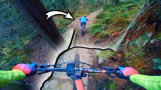
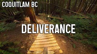
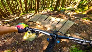
Old school trail with new school flair. Steep, some narrow/technical trail features with no ride around options.
The difficulty of this trail goes up when there is moisture on the trail.

Because of how steep it is, it's not suitable for riding in the rain.

This trail is unsanctioned.

Disclaimer

Please avoid riding in wet weather to prevent erosion and trail damage. TTFs and steeps have no ride-arounds.

Trail Supporters

Recent Activity on Trail

Past Week
  • 1 rides
  • 6 miles average
6 Months
  • 28 rides
  • 11 miles avg distance
All
  • 345 rides
  • Last: Jun 18, 2026
c1c2c3c4
January
February
March
April
May
June
July
August
September
October
November
December
update trails status or condition

Deliverance Trail Reports

statusdatedescription
Mar 31, 2026 @ 4:09pm (America/Vancouver)
Mar 31, 2026
Feb 4, 2026 @ 6:17pm (America/Vancouver)
Feb 4, 2026
Tree has been cleared. Smooth sailing
Jan 16, 2026 @ 1:57pm (America/Vancouver)
Jan 16, 2026
Tree down
Jan 8, 2026 @ 8:13pm (America/Vancouver)
Jan 8, 2026
reporter At least two large trees down, crossing the trail (and ride-around) multiple times at around 500m elevation. Will be impossible to get bikes...
Jan 4, 2026 @ 9:10pm (America/Vancouver)
Jan 4, 2026
tree down at entrance of trail blocking first chute
more »
Status:
on Mar 31, 2026
Ideal
Avg: 4.62 (36 votes)
Your vote: 0

view (1,726)
close
3D
Trail Conditions
  • Unknown
  • Snow Groomed
  • Snow Packed
  • Snow Covered
  • Snow Cover Partial
  • Freeze/thaw Cycle
  • Icy
  • Prevalent Mud
  • Wet
  • Variable
  • Ideal
  • Dry
  • Very Dry
Trail Flow (Ridden Direction)
Trailforks scans users ridelogs to determine the most popular direction each trail is ridden. A good flowing trail network will have most trails flowing in a single direction according to their intension.
The colour categories are based on what percentage of riders are riding a trail in its intended direction.
  • > 96%
  • > 90%
  • > 80%
  • > 70%
  • > 50%
  • < 50%
  • bi-directional trail
  • no data
Trail Last Ridden
Trailforks scans ridelogs to determine the last time a trail was ridden.
  • < 2 days
  • < 1 week
  • < 2 weeks
  • < 1 month
  • < 6 months
  • > 6 months
Trail Ridden Direction
The intended direction a trail should be ridden.
  • Downhill Only
  • Downhill Primary
  • Both Directions
  • Uphill Primary
  • Uphill Only
  • One Direction
Contribute Details
Colors indicate trail is missing specified detail.
  • Description
  • Photos
  • Description & Photos
  • Videos
Trail Popularity ?
Trailforks scans ridelogs to determine which trails are ridden the most in the last 9 months. Trails are compared with nearby trails in the same city region with a possible 25 colour shades. Think of this as a heatmap, more rides = more kinetic energy = warmer colors.
  • most popular
  • popular
  • less popular
  • not popular
ATV/ORV/OHV Filter
Max Vehicle Width
inches
US Cell Coverage
Legend
cell carrier legend

Radar Time
Activity Recordings
Trailforks uses anonymized public activity data. ?
Activity Recordings
Trailforks uses anonymized public activity data. ?
Personal Heatmap
Activity Types
all / none
Options
2
Date range month
Winter Trails
Warning A routing network for winter maps does not exist. Selecting trails using the winter trails layer has been disabled.
Missing Trails
Most Popular
Least Popular
Trails are colored based on popularity. The more popular a trail is, the more red. Less popular trails trend towards green.
Jump Magnitude Heatmap
Heatmap of where riders jump on trails. Zoom in to see individual jumps, click circles to view jump details.
BC Backroad Status

Service Road Atlas is a free to use, community-driven service for viewing and creating reports on the numerous back-country service roads around B.C. and Alberta.

map legend
Slope Aspect
Direction the slope faces
Flat N NE E SE S SW W NW
Trails Deemphasized
Trails are shown in grey.
disable
Only show trails with no bike usage.
Enable
Suggested Layers
Based on selected activity type

    Save the current map location and zoom level as your default home location whenever this page is loaded.

    Save
        Directions to deliverance trailhead (49.315980, -122.734700)

        Photos

        22 more »
        46 |
        Dec 29, 2025 @ 8:48pm
        Dec 29, 2025
        138 |
        Aug 7, 2023 @ 7:17pm
        Aug 7, 2023
        167 |
        Nov 28, 2020 @ 8:21pm
        Nov 28, 2020
        514 |
        Sep 21, 2014 @ 8:47am
        Sep 21, 2014

        Videos

        17 more »
        youtuber From Blue Square Rider to Double Black
        15:17 | 505 | Mar 5, 2023 , Coquitlam
        youtuber Deliverance & Lower Elevator - Burke...
        5:58 | 523 | Sep 13, 2022 , Coquitlam
        youtuber The GNARLIEST Trails on the mountain! - But on...
        14:15 | 229 | Aug 29, 2024 , Coquitlam
        youtuber How to Level-Up Your Riding Skills [#1]
        20:51 | 230 | Jun 28, 2023 , Coquitlam

        Trail Products

        32 Reviews & Comments


        We hope you've been enjoying Trailforks!

        Create a FREE account to view trail comments and much more.

        • #8506 - 10,651 views

        Frequently Asked Questions About Deliverance

        Where is Deliverance located?
        Deliverance is located in Burke Mountain, Coquitlam, British Columbia, Canada. It is part of the Burke Mountain trail network. The trailhead is located at coordinates 49.31598, -122.7347.
        How hard is Deliverance?
        Deliverance is rated as Double Black Diamond difficulty. The physical rating is Hard. The average grade is 31.6%. The climb difficulty is rated Green.
        What is the elevation gain for Deliverance?
        The trail has 168 m of elevation descent. The elevation ranges from 462 m to 630 m.
        Is Deliverance a point to point trail?
        Yes, Deliverance is a point to point trail. The direction is Downhill Only. The trail type is singletrack.

        Hit the Trail

        Open in App

        Get this trail on your phone instantly.
        open trail in app

        Download Trail

        Save to wishlist, Garmin & download.
        save the trail

        Find Related Routes

        Find routes and users activities that include this trail.
        find routes for this trail

        You must enter a description before submitting.