more stats
1.4 miles
Distance
98 ft
Climb
-717 ft
Descent
00:13:13
Avg time
-621 ft
Altitude change
3,416 ft
Altitude min
4,037 ft
Altitude max
4,037 ft
Altitude start
3,415 ft
Altitude end
-8.5%
Grade
-69%
Grade max
45.3%
Grade min
725 ft
Distance climb
1 mile
Distance down
249 ft
Distance flat
00:13:13
Avg time

Dem Bones Details

  • Activities
    • Mountain Bike
    • E-Bike
    • Winter Fat Bike
    • Hike
    • Trail Running
    • Snowshoe
  • Riding Area
    Mt Fernie
    Fernie, British Columbia
  • Difficulty Rating
  • Voted Difficulty
    Black Diamond (1 vote)
  • Local Popularity
    75 in Mountain Biking [+]
    • 75 in E-Biking
    • 90 in Trail Running
    • 75 in Hiking
    • 95 in Snowshoeing
  • Global Ranking
    #66872 in Mountain Biking [+]
    • #55774 in E-Biking
    • #34536 in Trail Running
    • #72347 in Hiking
    • #516 in Snowshoeing
  • Trail Type
    Singletrack
  • Snow Grooming
    Groomed Smooth
  • Bike Type
    AM, XC, Fat
  • Direction
    Both Directions
    Popular Direction Shown
  • Climb Difficulty
    Blue
  • Dogs Allowed
    Yes
  • eBike Allowed
    Yes up to Class 1

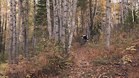
A Fernie classic. Rooty, flowy, with lots of twists and turns. A great climb and a great descent. There are a couple of tiny features for those who want to try them out.

Access Info

Ride through the campground, staying to the North side of it (turn right immediately after entering the campground area), turn right on a small road next to a service building and both Stove and Dem Bones trailheads are right there.

Local Trail Association
  • trail association logo
  • Please consider joining or donating to the local trail association to support
    trail development & maintenance.
Traditionally Indigenous Territory

Recent Activity on Trail

Past Week
  • 4 rides
  • 8 miles average
6 Months
  • 27 rides
  • 8 miles avg distance
All
  • 523 rides
  • Last: Jun 16, 2026
c1c2c3c4
January
February
March
April
May
June
July
August
September
October
November
December
update trails status or condition

Dem Bones Trail Reports

statusdatedescription
Apr 30, 2026 @ 12:07pm (America/Edmonton)
Apr 30, 2026
Good to go although needs some love to address erosion
Apr 25, 2026 @ 6:00pm (America/Edmonton)
Apr 25, 2026
reporter Trail is snow free except for a few small patches on the flats at the top. Tread is generally firm and good but winter storms have made ruts...
Apr 19, 2026 @ 2:39pm (America/Edmonton)
Apr 19, 2026
reporter April 18 - Top half-ish snow covered. Bottom half dry
Mar 30, 2026 @ 2:14pm (America/Edmonton)
Mar 30, 2026
Trail is snow covered, but ground is no longer as firm as in winter. Use caution as snow melts as riding when soft can cause trail damage.
Jan 18, 2026 @ 2:55pm (America/Edmonton)
Jan 18, 2026
Lots of big post holes from moose that are frozen into the trail. Still rideable but they toss you around a bit
more »
Status:
on Apr 30, 2026
Dry
Avg: 3.45 (26 votes)
Your vote: 0

view (3,060)
close
3D
Trail Conditions
  • Unknown
  • Snow Groomed
  • Snow Packed
  • Snow Covered
  • Snow Cover Partial
  • Freeze/thaw Cycle
  • Icy
  • Prevalent Mud
  • Wet
  • Variable
  • Ideal
  • Dry
  • Very Dry
Trail Flow (Ridden Direction)
Trailforks scans users ridelogs to determine the most popular direction each trail is ridden. A good flowing trail network will have most trails flowing in a single direction according to their intension.
The colour categories are based on what percentage of riders are riding a trail in its intended direction.
  • > 96%
  • > 90%
  • > 80%
  • > 70%
  • > 50%
  • < 50%
  • bi-directional trail
  • no data
Trail Last Ridden
Trailforks scans ridelogs to determine the last time a trail was ridden.
  • < 2 days
  • < 1 week
  • < 2 weeks
  • < 1 month
  • < 6 months
  • > 6 months
Trail Ridden Direction
The intended direction a trail should be ridden.
  • Downhill Only
  • Downhill Primary
  • Both Directions
  • Uphill Primary
  • Uphill Only
  • One Direction
Contribute Details
Colors indicate trail is missing specified detail.
  • Description
  • Photos
  • Description & Photos
  • Videos
Trail Popularity ?
Trailforks scans ridelogs to determine which trails are ridden the most in the last 9 months. Trails are compared with nearby trails in the same city region with a possible 25 colour shades. Think of this as a heatmap, more rides = more kinetic energy = warmer colors.
  • most popular
  • popular
  • less popular
  • not popular
ATV/ORV/OHV Filter
Max Vehicle Width
inches
US Cell Coverage
Legend
cell carrier legend

Radar Time
Activity Recordings
Trailforks uses anonymized public activity data. ?
Activity Recordings
Trailforks uses anonymized public activity data. ?
Personal Heatmap
Activity Types
all / none
Options
2
Date range month
Winter Trails
Warning A routing network for winter maps does not exist. Selecting trails using the winter trails layer has been disabled.
Missing Trails
Most Popular
Least Popular
Trails are colored based on popularity. The more popular a trail is, the more red. Less popular trails trend towards green.
Jump Magnitude Heatmap
Heatmap of where riders jump on trails. Zoom in to see individual jumps, click circles to view jump details.
BC Backroad Status

Service Road Atlas is a free to use, community-driven service for viewing and creating reports on the numerous back-country service roads around B.C. and Alberta.

map legend
Slope Aspect
Direction the slope faces
Flat N NE E SE S SW W NW
Trails Deemphasized
Trails are shown in grey.
disable
Only show trails with no bike usage.
Enable
Suggested Layers
Based on selected activity type

    Save the current map location and zoom level as your default home location whenever this page is loaded.

    Save
        Directions to dem-bones-16607 trailhead (49.503730, -115.100040)

        Photos

        43 more »
        235 |
        Apr 10, 2020 @ 2:58pm
        Apr 10, 2020
        494 |
        Jun 3, 2011 @ 7:53am
        Jun 3, 2011
        126 |
        Aug 10, 2021 @ 10:45am
        Aug 10, 2021
        124 |
        Apr 10, 2020 @ 2:58pm
        Apr 10, 2020

        Videos

        2 more »
        Cody Macarthur//Fernie Fall
        2:16 | 13146 | Oct 24, 2015 , Fernie
        Doli Test
        0:59 | 201 | May 29, 2010 , Fernie

        Routes with this trail

        4.4 8 miles 2,145 ft 22 Out & Back
        This is The Guides Hut's trail route recommendation. The rout goes down Dem Bones, then connects onto...
        1.0 5 miles 841 ft 12
        2nd 1/2 of Lazy Lizard, , Eric's Trip &
        8 miles 2,227 ft 26
        From across Stanford Resort: 1) Go up to 1st parking lot 2) Go into campsite area, keep to right to find...

        5 Reviews & Comments


        We hope you've been enjoying Trailforks!

        Create a FREE account to view trail comments and much more.

        • By canadakaTF Pro Trailforks & contributors
        • #16607 - 6,730 views

        Frequently Asked Questions About Dem Bones

        Where is Dem Bones located?
        Dem Bones is located in Mt Fernie, Fernie, British Columbia, Canada. It is part of the Mt Fernie trail network. The trailhead is located at coordinates 49.50373, -115.10004.
        How hard is Dem Bones?
        Dem Bones is rated as Blue difficulty. The average grade is 8.5%. The climb difficulty is rated Blue.
        What is the elevation gain for Dem Bones?
        Dem Bones has 98 ft of elevation gain. The trail has 717 ft of elevation descent. The elevation ranges from 3,416 ft to 4,037 ft.
        Is Dem Bones a point to point trail?
        Dem Bones is not a point to point trail. The direction is Both Directions. The trail type is singletrack.

        Hit the Trail

        Open in App

        Get this trail on your phone instantly.
        open trail in app

        Download Trail

        Save to wishlist, Garmin & download.
        save the trail

        Find Related Routes

        Find routes and users activities that include this trail.
        find routes for this trail

        You must enter a description before submitting.