more stats
4,281 ft
Distance
124 ft
Climb
-545 ft
Descent
00:17:59
Avg time
-421 ft
Altitude change
1,893 ft
Altitude min
2,435 ft
Altitude max
2,314 ft
Altitude start
1,893 ft
Altitude end
-9.8%
Grade
-50.7%
Grade max
37.6%
Grade min
873 ft
Distance climb
3,081 ft
Distance down
331 ft
Distance flat
00:17:59
Avg time

The Den Details

  • Activities
    • Mountain Bike
    • E-Bike
  • Riding Area
    Vedder Mountain
    Chilliwack, British Columbia
  • Difficulty Rating
  • Local Popularity
    80 in Mountain Biking [+]
    • 95 in E-Biking
  • Global Ranking
    #39587 in Mountain Biking [+]
    • #15748 in E-Biking
  • Trail Type
    Singletrack
  • Bike Type
    DH, AM
  • Direction
    Downhill Only
    Popular Direction Shown
  • Dogs Allowed
    Yes
  • eBike Allowed
    Yes up to Class 1
  • TTFs on Trail
    Jump, Skinny
  • Land Owner
    RSTBC

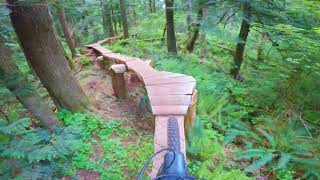
At 6.9km to the trailhead this lengthy push is rewarded with super loamy, natural singletrack. Narrow moderately steep trail with a long log ride near the start(can be walked). The trail contains a few technical tight switchbacks mid trail. the Den be connected to repo mid trail or to 2 cents after a short climb up the road at the end.

Local Trail Association
Traditionally Indigenous Territory

Recent Activity on Trail

Past Week
  • 5 rides
  • 26.9 km average
6 Months
  • 14 rides
  • 21.0 km avg distance
All
  • 215 rides
  • Last: Jun 20, 2026
c1c2c3c4
January
February
March
April
May
June
July
August
September
October
November
December
update trails status or condition

The Den Trail Reports

statusdatedescription
Apr 29, 2026 @ 11:03am (America/Vancouver)
Apr 29, 2026
2 trees down across the trail, both close to each other, shortly after the log ride
Apr 5, 2026 @ 9:55am (America/Vancouver)
Apr 5, 2026
Large tree down across trail, blocking trail. Needs a chainsaw
Apr 4, 2026 @ 11:29am (America/Vancouver)
Apr 4, 2026
Two trees across the trail just a little past the log ride. The first will need a chainsaw (photo wouldn’t upload, sorry). 2nd is just below...
Feb 4, 2026 @ 12:52pm (America/Vancouver)
Feb 4, 2026
Numerous trees down on the log ride. A couple other trees down throughout. Tried to clear as much blowdown as possible on my way down. Not in the...
Oct 25, 2025 @ 2:39pm (America/Vancouver)
Oct 25, 2025
reporter
Cleared trees
more » 4 social media mentions
Status:
on Apr 29, 2026
Variable
Avg: 4.35 (24 votes)
Your vote: 0

view (2,103)
close
3D
Trail Conditions
  • Unknown
  • Snow Groomed
  • Snow Packed
  • Snow Covered
  • Snow Cover Partial
  • Freeze/thaw Cycle
  • Icy
  • Prevalent Mud
  • Wet
  • Variable
  • Ideal
  • Dry
  • Very Dry
Trail Flow (Ridden Direction)
Trailforks scans users ridelogs to determine the most popular direction each trail is ridden. A good flowing trail network will have most trails flowing in a single direction according to their intension.
The colour categories are based on what percentage of riders are riding a trail in its intended direction.
  • > 96%
  • > 90%
  • > 80%
  • > 70%
  • > 50%
  • < 50%
  • bi-directional trail
  • no data
Trail Last Ridden
Trailforks scans ridelogs to determine the last time a trail was ridden.
  • < 2 days
  • < 1 week
  • < 2 weeks
  • < 1 month
  • < 6 months
  • > 6 months
Trail Ridden Direction
The intended direction a trail should be ridden.
  • Downhill Only
  • Downhill Primary
  • Both Directions
  • Uphill Primary
  • Uphill Only
  • One Direction
Contribute Details
Colors indicate trail is missing specified detail.
  • Description
  • Photos
  • Description & Photos
  • Videos
Trail Popularity ?
Trailforks scans ridelogs to determine which trails are ridden the most in the last 9 months. Trails are compared with nearby trails in the same city region with a possible 25 colour shades. Think of this as a heatmap, more rides = more kinetic energy = warmer colors.
  • most popular
  • popular
  • less popular
  • not popular
ATV/ORV/OHV Filter
Max Vehicle Width
inches
US Cell Coverage
Legend
cell carrier legend

Radar Time
Activity Recordings
Trailforks uses anonymized public activity data. ?
Activity Recordings
Trailforks uses anonymized public activity data. ?
Personal Heatmap
Activity Types
all / none
Options
2
Date range month
Winter Trails
Warning A routing network for winter maps does not exist. Selecting trails using the winter trails layer has been disabled.
Missing Trails
Most Popular
Least Popular
Trails are colored based on popularity. The more popular a trail is, the more red. Less popular trails trend towards green.
Jump Magnitude Heatmap
Heatmap of where riders jump on trails. Zoom in to see individual jumps, click circles to view jump details.
BC Backroad Status

Service Road Atlas is a free to use, community-driven service for viewing and creating reports on the numerous back-country service roads around B.C. and Alberta.

map legend
Slope Aspect
Direction the slope faces
Flat N NE E SE S SW W NW
Trails Deemphasized
Trails are shown in grey.
disable
Only show trails with no bike usage.
Enable
Suggested Layers
Based on selected activity type

    Save the current map location and zoom level as your default home location whenever this page is loaded.

    Save
        Directions to den trailhead (49.058550, -122.023880)

        Photos

        71 more »
        1,056 |
        Sep 18, 2017 @ 8:01am
        Sep 18, 2017
        352 |
        Apr 1, 2014 @ 11:57am
        Apr 1, 2014
        36 |
        Sep 3, 2023 @ 3:31pm
        Sep 3, 2023
        117 |
        Feb 17, 2020 @ 2:03pm
        Feb 17, 2020

        Videos

        9 more »
        youtuber Getting To Know You Vedder  - The Den &...
        15:21 | 117 | Jun 11, 2025 , Chilliwack
        youtuber These Trails are Flowy, Fast and you can even...
        13:32 | 459 | Sep 6, 2022 , Chilliwack
        youtuber Memorizing a New Mountain
        17:39 | 460 | Apr 2, 2022 , Chilliwack
        youtuber The Hardcore South Shore?- The Den & 2...
        8:05 | 267 | Jan 8, 2023 , Chilliwack

        Routes with this trail

        13 miles 3,633 ft 23
        Vedder Trail Blazer 2015 Map For First Aid
        2.0 16 miles 4,100 ft 32
        Bro Trip Vedder Lap! Can cut short if needed.
        9 miles 2,404 ft 40
        Fraser Valley Vedder Classic Fraser Valley Relive Your Rides For other ride suggestions for this and other...

        3 Reviews & Comments


        We hope you've been enjoying Trailforks!

        Create a FREE account to view trail comments and much more.

        • By BCpovTF Pro & contributors
        • #963 - 9,384 views

        Frequently Asked Questions About The Den

        Where is The Den located?
        The Den is located in Vedder Mountain, Chilliwack, British Columbia, Canada. It is part of the Vedder Mountain trail network. The trailhead is located at coordinates 49.05855, -122.02388.
        How hard is The Den?
        The Den is rated as Black Diamond difficulty. The average grade is 9.8%.
        What is the elevation gain for The Den?
        The Den has 38 m of elevation gain. The trail has 166 m of elevation descent. The elevation ranges from 577 m to 742 m.
        Is The Den a point to point trail?
        Yes, The Den is a point to point trail. The direction is Downhill Only. The trail type is singletrack.

        Hit the Trail

        Open in App

        Get this trail on your phone instantly.
        open trail in app

        Download Trail

        Save to wishlist, Garmin & download.
        save the trail

        Find Related Routes

        Find routes and users activities that include this trail.
        find routes for this trail

        You must enter a description before submitting.