more stats
8.6 miles
Distance
686 ft
Climb
-577 ft
Descent
00:45:51
Avg time
109 ft
Altitude change
1,333 ft
Altitude min
1,587 ft
Altitude max
1,395 ft
Altitude start
1,503 ft
Altitude end
0.2%
Grade
-19.4%
Grade max
15.4%
Grade min
4 miles
Distance climb
3 miles
Distance down
1 mile
Distance flat
00:45:51
Avg time

Desert Classic Details

  • Activities
    • Mountain Bike
    • E-Bike
    • Horse
    • Hike
    • Trail Running
  • Riding Area
    South Mountain Preserve
    Phoenix, Arizona
  • Difficulty Rating
  • Voted Difficulty
    Blue (6 votes)
  • Local Popularity
    90 in Mountain Biking [+]
    • 90 in E-Biking
    • 60 in Trail Running
    • 35 in Hiking
    • 5 in Horseback
  • Global Ranking
    #1843 in Mountain Biking [+]
    • #2143 in E-Biking
    • #444 in Trail Running
    • #22779 in Hiking
  • Trail Type
    Singletrack
  • Bike Type
    DH, AM, XC, DJ
  • Direction
    Both Directions
    Popular In Reverse
  • Climb Difficulty
    Blue
  • Physical Rating
    Moderate
  • Season
    Year round
  • Dogs Allowed
    Yes
  • eBike Allowed
    Yes up to Class 1
  • Ride in Rain
    Yes
  • Land Owner

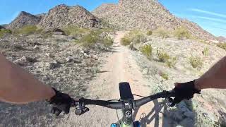
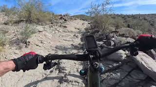
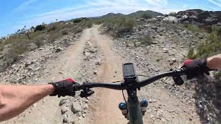
Desert Classic trail connects the east and west ends of the southwest quadrant of south mountain riding area. About 13 miles across the lower flats of the south west range it ascends from east to west and descends west to east. Pima Canyon which is a large ramada with parking at the east end and Telegraph pass which is a small ramada and parking at the west end. Desert Classic is the classic trail ride.

Access Info

Pima Canyon, Telegraph Pass, Warpaint, Western Star, various trailheads

Local Trail Association
Traditionally Indigenous Territory

Recent Activity on Trail

Past Week
  • 3 rides
  • 19 miles average
6 Months
  • 99 rides
  • 18 miles avg distance
All
  • 909 rides
  • Last: Jun 14, 2026
c1c2c3c4
January
February
March
April
May
June
July
August
September
October
November
December
update trails status or condition

Desert Classic Trail Reports

statusdatedescription
May 17, 2026 @ 4:41pm (America/Phoenix)
May 17, 2026
Apr 21, 2026 @ 10:12am (America/Phoenix)
Apr 21, 2026
It’s just fine, fun xc trail
Apr 17, 2026 @ 1:45pm (America/Phoenix)
Apr 17, 2026
Dec 28, 2025 @ 8:20am (America/Phoenix)
Dec 28, 2025
Dec 8, 2025 @ 4:52pm (America/Phoenix)
Dec 8, 2025
This trail has really deteriorated since I rode it in the spring, the wash crossings/chutes were very eroded, they are more challenging than ever
more »
Status:
on May 17, 2026
Ideal
Avg: 3.99 (65 votes)
Your vote: 0

view (7,263)
close
3D
Trail Conditions
  • Unknown
  • Snow Groomed
  • Snow Packed
  • Snow Covered
  • Snow Cover Partial
  • Freeze/thaw Cycle
  • Icy
  • Prevalent Mud
  • Wet
  • Variable
  • Ideal
  • Dry
  • Very Dry
Trail Flow (Ridden Direction)
Trailforks scans users ridelogs to determine the most popular direction each trail is ridden. A good flowing trail network will have most trails flowing in a single direction according to their intension.
The colour categories are based on what percentage of riders are riding a trail in its intended direction.
  • > 96%
  • > 90%
  • > 80%
  • > 70%
  • > 50%
  • < 50%
  • bi-directional trail
  • no data
Trail Last Ridden
Trailforks scans ridelogs to determine the last time a trail was ridden.
  • < 2 days
  • < 1 week
  • < 2 weeks
  • < 1 month
  • < 6 months
  • > 6 months
Trail Ridden Direction
The intended direction a trail should be ridden.
  • Downhill Only
  • Downhill Primary
  • Both Directions
  • Uphill Primary
  • Uphill Only
  • One Direction
Contribute Details
Colors indicate trail is missing specified detail.
  • Description
  • Photos
  • Description & Photos
  • Videos
Trail Popularity ?
Trailforks scans ridelogs to determine which trails are ridden the most in the last 9 months. Trails are compared with nearby trails in the same city region with a possible 25 colour shades. Think of this as a heatmap, more rides = more kinetic energy = warmer colors.
  • most popular
  • popular
  • less popular
  • not popular
ATV/ORV/OHV Filter
Max Vehicle Width
inches
US Cell Coverage
Legend
cell carrier legend

Radar Time
Activity Recordings
Trailforks uses anonymized public activity data. ?
Activity Recordings
Trailforks uses anonymized public activity data. ?
Personal Heatmap
Activity Types
all / none
Options
2
Date range month
Winter Trails
Warning A routing network for winter maps does not exist. Selecting trails using the winter trails layer has been disabled.
Missing Trails
Most Popular
Least Popular
Trails are colored based on popularity. The more popular a trail is, the more red. Less popular trails trend towards green.
Jump Magnitude Heatmap
Heatmap of where riders jump on trails. Zoom in to see individual jumps, click circles to view jump details.
BC Backroad Status

Service Road Atlas is a free to use, community-driven service for viewing and creating reports on the numerous back-country service roads around B.C. and Alberta.

map legend
Slope Aspect
Direction the slope faces
Flat N NE E SE S SW W NW
Trails Deemphasized
Trails are shown in grey.
disable
Only show trails with no bike usage.
Enable
Suggested Layers
Based on selected activity type

    Save the current map location and zoom level as your default home location whenever this page is loaded.

    Save
        Directions to desert-classic trailhead (33.362840, -111.986080)

        Photos

        60 more »
        744 |
        Mar 12, 2019 @ 10:56pm
        Mar 12, 2019
        693 |
        Nov 22, 2018 @ 3:20pm
        Nov 22, 2018
        673 |
        Jul 16, 2017 @ 4:32pm
        Jul 16, 2017
        999 |
        Mar 30, 2016 @ 12:19pm
        Mar 30, 2016

        Videos

        15 more »
        youtuber ALL THE PLANTS ARE TRYING TO KILL YOU // Last...
        8:51 | 1711 | Mar 8, 2018 , Phoenix
        Desert Classic - Back Fun Parts
        21:21 | 75 | Mar 30, 2026 , Phoenix
        Desert Classic - Back to Parking Full Trail
        51:03 | 68 | Mar 30, 2026 , Phoenix
        Desert Classic Out
        27:59 | 74 | Mar 21, 2026 , Phoenix

        Routes with this trail

        4.0 3 miles 543 ft 3 Out & Back
        Nice ride on , then a hard grind up to and old helicopter pad for a nice view of Phoenix's East Valley.
        4.0 15 miles 1,350 ft 9
        Cross country with a climb at the halfway point.
        4.5 10 miles 564 ft 17 Out & Back
        South Mountain intro ride for beginners / lower intermediate riders. A few short steep wash crossings will...

        13 Reviews & Comments


        We hope you've been enjoying Trailforks!

        Create a FREE account to view trail comments and much more.

        • By toddTF Pro Trailforks & contributors
        • #14930 - 24,597 views

        Frequently Asked Questions About Desert Classic

        Where is Desert Classic located?
        Desert Classic is located in South Mountain Preserve, Phoenix, Arizona, United States. It is part of the South Mountain Preserve trail network. The trailhead is located at coordinates 33.36284, -111.98608.
        How hard is Desert Classic?
        Desert Classic is rated as Blue difficulty. The physical rating is Moderate. The average grade is 0.2%. The climb difficulty is rated Blue.
        What is the elevation gain for Desert Classic?
        Desert Classic has 686 ft of elevation gain. The trail has 577 ft of elevation descent. The elevation ranges from 1,333 ft to 1,587 ft.
        Is Desert Classic a point to point trail?
        Desert Classic is not a point to point trail. The direction is Both Directions. The trail type is singletrack.

        Hit the Trail

        Open in App

        Get this trail on your phone instantly.
        open trail in app

        Download Trail

        Save to wishlist, Garmin & download.
        save the trail

        Find Related Routes

        Find routes and users activities that include this trail.
        find routes for this trail

        You must enter a description before submitting.