

Open in App
Get this trail on your phone instantly.

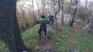
Sentiero realizzato recentemente che prevede una prima parte di mangia e bevi sul crinale che scende verso la val Taro, poi si trasforma in un bel flow nel bosco, il tutto condito da alcuni rilanci e da qualche salto drop naturale tecnico ma evitabile con percorso alternativo.
Il tutto segnalato da cartelli e simboli ben visibili.
Dalla strada principale che porta verso Cassio sulla sinistra sale una carraia che porta al promontorio con un boschetto dove si trova l'imbocco del sentiero.
This trail is unsanctioned.
| c1 | c2 | c3 | c4 |
|---|---|---|---|
January | February | March | April |
May | June | July | August |
September | October | November | December |

Service Road Atlas is a free to use, community-driven service for viewing and creating reports on the numerous back-country service roads around B.C. and Alberta.
Save the current map location and zoom level as your default home location whenever this page is loaded.
SaveWe hope you've been enjoying Trailforks!
Create a FREE account to view trail comments and much more.
You must enter a description before submitting.

