more stats
7.7 miles
Distance
2,375 ft
Climb
-3,150 ft
Descent
02:30:40
Avg time
-775 ft
Altitude change
1,932 ft
Altitude min
4,254 ft
Altitude max
3,105 ft
Altitude start
2,329 ft
Altitude end
-1.9%
Grade
-80.5%
Grade max
76.9%
Grade min
3 miles
Distance climb
4 miles
Distance down
489 ft
Distance flat
02:30:40
Avg time

Devils Creek Track Details

  • Activities
    • Mountain Bike
    • Gravel Bike
    • Hike
    • Trail Running
  • Riding Area
    Moonlight/Moke Lake
    Queenstown
  • Difficulty Rating
  • Local Popularity
    15 in Mountain Biking [+]
    • 55 in Trail Running
    • 5 in Hiking
  • Global Ranking
    #100589 in Mountain Biking [+]
    • #75381 in Trail Running
  • Hiking SAC Scale
    T2 Mountain Hiking
  • Trail Type
    Dirt/Gravel Road
  • Bike Type
    AM, XC, Gravel
  • Direction
    Both Directions[+]
    Popular Direction Shown
    • Both Directions for Gravel Biking
  • Climb Difficulty
    Black Diamond
  • Physical Rating
    Extreme
  • Trail Visibility
    Sometimes hard to follow
  • Season
    Nov - Apr
  • Dogs Allowed
    Yes
  • Land Owner

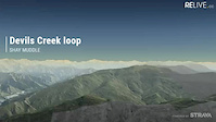
Huge climbs, huge descents, all 4WD some quite overgrown with tall grass but well signposted by DOC. Take comfortable walking shoes as there is plenty of pushing up hills Some great views into Skippers from the top of Mt Dewer and good views up moonlight towards Moke Lake when descending down to Devils Creek. This is sheep country so remember to keep your mouth closed on the downhills!

Access Info

Go up to Skippers saddle from Queenstown and turn left a few meters after the Skippers saddle gate.

Traditionally Indigenous Territory

Recent Activity on Trail

Past Week
  • 0 rides
  •  
6 Months
  • 1 rides
  • 9 miles avg distance
All
  • 7 rides
  • Last: Feb 22, 2026
c1c2c3c4
January
February
March
April
May
June
July
August
September
October
November
December
update trails status or condition

Devils Creek Track Trail Reports

statusdatedescription
Nov 15, 2025 @ 12:55pm (Pacific/Auckland)
Nov 14, 2025
May 27, 2025 @ 10:34pm
May 27, 2025
Closed for Winter! Please keep off the trail to prevent damage. Will let you know when it's back open in spring.
Mar 6, 2025 @ 11:50am
Mar 6, 2025
Great trail with amazing views. Some big climbs but perfectly rideable. Fast down hill sections, it’s a 4WD track but not rutted or torn up so...
Jan 24, 2023 @ 6:49pm
Jan 24, 2023
Significant issue is that this is huge time waster, don't. It has a 3 and a 2 km long climbs that are super steep, very long 20-30% sections,...
Feb 13, 2015 @ 4:30pm
Feb 13, 2015
Minor erosion (trail braiding, small ruts developing, brake bumps) and overgrown with grass in places, a bit wet on climb from Devils Creek.
more »
Status:
on Nov 15, 2025
Avg: 3.21 (3 votes)
Your vote: 0

view (43)
close
3D
Trail Conditions
  • Unknown
  • Snow Groomed
  • Snow Packed
  • Snow Covered
  • Snow Cover Partial
  • Freeze/thaw Cycle
  • Icy
  • Prevalent Mud
  • Wet
  • Variable
  • Ideal
  • Dry
  • Very Dry
Trail Flow (Ridden Direction)
Trailforks scans users ridelogs to determine the most popular direction each trail is ridden. A good flowing trail network will have most trails flowing in a single direction according to their intension.
The colour categories are based on what percentage of riders are riding a trail in its intended direction.
  • > 96%
  • > 90%
  • > 80%
  • > 70%
  • > 50%
  • < 50%
  • bi-directional trail
  • no data
Trail Last Ridden
Trailforks scans ridelogs to determine the last time a trail was ridden.
  • < 2 days
  • < 1 week
  • < 2 weeks
  • < 1 month
  • < 6 months
  • > 6 months
Trail Ridden Direction
The intended direction a trail should be ridden.
  • Downhill Only
  • Downhill Primary
  • Both Directions
  • Uphill Primary
  • Uphill Only
  • One Direction
Contribute Details
Colors indicate trail is missing specified detail.
  • Description
  • Photos
  • Description & Photos
  • Videos
Trail Popularity ?
Trailforks scans ridelogs to determine which trails are ridden the most in the last 9 months. Trails are compared with nearby trails in the same city region with a possible 25 colour shades. Think of this as a heatmap, more rides = more kinetic energy = warmer colors.
  • most popular
  • popular
  • less popular
  • not popular
ATV/ORV/OHV Filter
Max Vehicle Width
inches
US Cell Coverage
Legend
cell carrier legend

Radar Time
Activity Recordings
Trailforks uses anonymized public activity data. ?
Activity Recordings
Trailforks uses anonymized public activity data. ?
Personal Heatmap
Activity Types
all / none
Options
2
Date range month
Winter Trails
Warning A routing network for winter maps does not exist. Selecting trails using the winter trails layer has been disabled.
Missing Trails
Most Popular
Least Popular
Trails are colored based on popularity. The more popular a trail is, the more red. Less popular trails trend towards green.
Jump Magnitude Heatmap
Heatmap of where riders jump on trails. Zoom in to see individual jumps, click circles to view jump details.
BC Backroad Status

Service Road Atlas is a free to use, community-driven service for viewing and creating reports on the numerous back-country service roads around B.C. and Alberta.

map legend
Slope Aspect
Direction the slope faces
Flat N NE E SE S SW W NW
Trails Deemphasized
Trails are shown in grey.
disable
Only show trails with no bike usage.
Enable
Suggested Layers
Based on selected activity type

    Save the current map location and zoom level as your default home location whenever this page is loaded.

    Save
        Directions to devils-creek-track trailhead (-44.940530, 168.705540)

        Photos

        96 more »
        59 |
        Nov 1, 2018 @ 8:27pm
        Nov 1, 2018
        48 |
        Nov 1, 2018 @ 8:27pm
        Nov 1, 2018
        44 |
        Nov 1, 2018 @ 8:27pm
        Nov 1, 2018
        102 |
        Mar 10, 2018 @ 10:52pm
        Mar 10, 2018

        Videos

        1 more »
        Devils Creek
        0:00 | 886 | Feb 22, 2017 , Queenstown

        Routes with this trail

        185 miles 39,064 ft 36
        Starting in Tāhuna , heading on bike path to Frankton ,taking in Remarkables, before returning to bike...

        2 Reviews & Comments


        We hope you've been enjoying Trailforks!

        Create a FREE account to view trail comments and much more.

        • By BrendhanTF Pro QMTBC & contributors
        • #25841 - 7,586 views

        Frequently Asked Questions About Devils Creek Track

        Where is Devils Creek Track located?
        Devils Creek Track is located in Moonlight/Moke Lake, Queenstown, New Zealand. It is part of the Moonlight/Moke Lake trail network. The trailhead is located at coordinates -44.94053, 168.70554.
        What is the elevation gain for Devils Creek Track?
        Devils Creek Track has 2,375 ft of elevation gain. The trail has 3,150 ft of elevation descent. The elevation ranges from 1,932 ft to 4,254 ft.
        Is Devils Creek Track a point to point trail?
        Devils Creek Track is not a point to point trail. The direction is Both Directions. The trail type is dirt/gravel road.
        How long is Devils Creek Track?
        Devils Creek Track is 7.7 miles long. The trail type is dirt/gravel road.

        Hit the Trail

        Open in App

        Get this trail on your phone instantly.
        open trail in app

        Download Trail

        Save to wishlist, Garmin & download.
        save the trail

        Find Related Routes

        Find routes and users activities that include this trail.
        find routes for this trail

        You must enter a description before submitting.