more stats
3.5 miles
Distance
571 ft
Climb
-473 ft
Descent
00:52:13
Avg time
98 ft
Altitude change
966 ft
Altitude min
1,209 ft
Altitude max
971 ft
Altitude start
1,070 ft
Altitude end
0.5%
Grade
-22.4%
Grade max
21.7%
Grade min
1 mile
Distance climb
5,062 ft
Distance down
1 mile
Distance flat
00:52:13
Avg time

Devils Racetrack Details

  • Activities
    • Mountain Bike
    • E-Bike
    • Hike
    • Trail Running
  • Riding Area
  • Difficulty Rating
  • Local Popularity
    65 in Mountain Biking [+]
    • 45 in E-Biking
    • 5 in Trail Running
    • 25 in Hiking
  • Global Ranking
    #16289 in Mountain Biking [+]
    • #20731 in E-Biking
    • #129775 in Trail Running
    • #118453 in Hiking
  • Hiking SAC Scale
    T4 Alpine Hiking
  • Trail Type
    Singletrack
  • Bike Type
    AM, XC
  • Direction
    Both Directions[+]
    • Both Directions for E-Biking
    • Both Directions for Trail Running
    • Both Directions for Hiking
  • Dogs Allowed
    Yes
  • eBike Allowed
    Yes up to Class 1
  • TTFs on Trail
    Rock Garden
  • Year Opened
    2021
  • Land Owner
    Arkansas State Parks

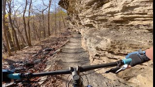
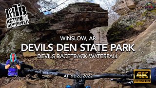
This trail travels almost the length of the park from the southernmost area to eventually link up with the Historic Fossil Flats Trail. The trail follows bluff lines taking riders and hikers under and behind waterfalls, through beautiful rock formations, past numerous alternative lines for more adventurous riders.

Access Info

The trail can be accessed from the camping areas, Goldbrick Trail and Fossil Flats Trail.

Trail Supporters
Local Trail Association

Recent Activity on Trail

Past Week
  • 2 rides
  • 21 miles average
6 Months
  • 27 rides
  • 14 miles avg distance
All
  • 113 rides
  • Last: Jun 16, 2026
c1c2c3c4
January
February
March
April
May
June
July
August
September
October
November
December
Status:
on Mar 29, 2026
Dry
Avg: 4.46 (10 votes)
Your vote: 0

view (613)
close
3D
Trail Conditions
  • Unknown
  • Snow Groomed
  • Snow Packed
  • Snow Covered
  • Snow Cover Partial
  • Freeze/thaw Cycle
  • Icy
  • Prevalent Mud
  • Wet
  • Variable
  • Ideal
  • Dry
  • Very Dry
Trail Flow (Ridden Direction)
Trailforks scans users ridelogs to determine the most popular direction each trail is ridden. A good flowing trail network will have most trails flowing in a single direction according to their intension.
The colour categories are based on what percentage of riders are riding a trail in its intended direction.
  • > 96%
  • > 90%
  • > 80%
  • > 70%
  • > 50%
  • < 50%
  • bi-directional trail
  • no data
Trail Last Ridden
Trailforks scans ridelogs to determine the last time a trail was ridden.
  • < 2 days
  • < 1 week
  • < 2 weeks
  • < 1 month
  • < 6 months
  • > 6 months
Trail Ridden Direction
The intended direction a trail should be ridden.
  • Downhill Only
  • Downhill Primary
  • Both Directions
  • Uphill Primary
  • Uphill Only
  • One Direction
Contribute Details
Colors indicate trail is missing specified detail.
  • Description
  • Photos
  • Description & Photos
  • Videos
Trail Popularity ?
Trailforks scans ridelogs to determine which trails are ridden the most in the last 9 months. Trails are compared with nearby trails in the same city region with a possible 25 colour shades. Think of this as a heatmap, more rides = more kinetic energy = warmer colors.
  • most popular
  • popular
  • less popular
  • not popular
ATV/ORV/OHV Filter
Max Vehicle Width
inches
US Cell Coverage
Legend
cell carrier legend

Radar Time
Activity Recordings
Trailforks uses anonymized public activity data. ?
Activity Recordings
Trailforks uses anonymized public activity data. ?
Personal Heatmap
Activity Types
all / none
Options
2
Date range month
Winter Trails
Warning A routing network for winter maps does not exist. Selecting trails using the winter trails layer has been disabled.
Missing Trails
Most Popular
Least Popular
Trails are colored based on popularity. The more popular a trail is, the more red. Less popular trails trend towards green.
Jump Magnitude Heatmap
Heatmap of where riders jump on trails. Zoom in to see individual jumps, click circles to view jump details.
BC Backroad Status

Service Road Atlas is a free to use, community-driven service for viewing and creating reports on the numerous back-country service roads around B.C. and Alberta.

map legend
Slope Aspect
Direction the slope faces
Flat N NE E SE S SW W NW
Trails Deemphasized
Trails are shown in grey.
disable
Only show trails with no bike usage.
Enable
Suggested Layers
Based on selected activity type

    Save the current map location and zoom level as your default home location whenever this page is loaded.

    Save
        Directions to devils-racetrack trailhead (35.770340, -94.267740)

        Photos

        32 more »
        23 |
        Apr 23, 2026 @ 3:28pm
        Apr 23, 2026
        31 |
        Apr 23, 2026 @ 3:28pm
        Apr 23, 2026
        25 |
        Apr 23, 2026 @ 3:28pm
        Apr 23, 2026
        31 |
        Apr 23, 2026 @ 12:42pm
        Apr 23, 2026

        Videos

        5 more »
        Devil's Racetrack | Mountain Biking at...
        17:04 | 262 | Dec 20, 2024 , Winslow
        youtuber MTB Riding Devils Racetrack at Devils Den...
        19:54 | 524 | Apr 23, 2022 , Winslow
        youtuber MTB Riding Devils Racetrack at Devils Den...
        4:18 | 447 | Apr 7, 2022 , Winslow
        Devils Racetrack, Devils Den State Park
        5:31 | 595 | Oct 28, 2021 , Winslow

        Routes with this trail

        4.0 14 miles 1,647 ft 6
        This is one of the best ways to link up the 'highlight' trails at Devil's Den State Park (namely Devil's...
        15 miles 1,812 ft 6 Loop
        A compilation route of the majority of the trails. Helpful if you are just driving in for the day or...
        10 miles 1,299 ft 3
        This route hits all the best trails at Devil’s Den, but doesn’t have as much climbing or miles as my...

        3 Reviews & Comments


        We hope you've been enjoying Trailforks!

        Create a FREE account to view trail comments and much more.

        • By ArkansasJoe CATA ARSP & contributors
        • #428520 - 7,014 views

        Frequently Asked Questions About Devils Racetrack

        Where is Devils Racetrack located?
        Devils Racetrack is located in Devils Den State Park - Monument Trails, Winslow, Arkansas, United States. It is part of the Devils Den State Park - Monument Trails trail network. The trailhead is located at coordinates 35.77034, -94.26774.
        How hard is Devils Racetrack?
        Devils Racetrack is rated as Blue difficulty. The average grade is 0.5%.
        What is the elevation gain for Devils Racetrack?
        Devils Racetrack has 571 ft of elevation gain. The trail has 473 ft of elevation descent. The elevation ranges from 966 ft to 1,209 ft.
        Is Devils Racetrack a point to point trail?
        Devils Racetrack is not a point to point trail. The direction is Both Directions. The trail type is singletrack.

        Hit the Trail

        Open in App

        Get this trail on your phone instantly.
        open trail in app

        Download Trail

        Save to wishlist, Garmin & download.
        save the trail

        Find Related Routes

        Find routes and users activities that include this trail.
        find routes for this trail

        You must enter a description before submitting.