more stats
3,022 ft
Distance
-287 ft
Descent
00:02:55
Avg time
-287 ft
Altitude change
1,149 ft
Altitude min
1,435 ft
Altitude max
1,435 ft
Altitude start
1,148 ft
Altitude end
-9.5%
Grade
-24.5%
Grade max
-1.2%
Grade min
2,963 ft
Distance down
59 ft
Distance flat
00:02:55
Avg time

OGre Run Details

  • Activities
    • Mountain Bike
    • E-Bike
  • Riding Area
    Lake Leatherwood City Park
    Eureka Springs, Arkansas
  • AKA
    DH-2
  • Difficulty Rating
  • Local Popularity
    100 in Mountain Biking [+]
    • 100 in E-Biking
  • Global Ranking
    #12965 in Mountain Biking [+]
    • #11326 in E-Biking
  • Trail Type
    Singletrack
  • Bike Type
    DH, AM
  • Physical Rating
    Moderate
  • eBike Allowed
    Yes up to Class 1
  • TTFs on Trail
    Berm, Drop, Jump, Gap Jump, Rock Face, Rock Garden

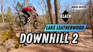
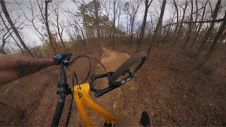
Downhill only trail. This upper trail section is primarily flowy consisting of berms with jumps, including one gap jump (watch out, not much of a lip to launch from). Everything has a B-line though, so you aren't locked in. Further down you'll find a rock garden that rolls into several drop options.

Trail Supporters
Local Trail Association

Recent Activity on Trail

Past Week
  • 0 rides
  •  
6 Months
  • 8 rides
  • 20 miles avg distance
All
  • 198 rides
  • Last: Jun 18, 2026
c1c2c3c4
January
February
March
April
May
June
July
August
September
October
November
December
Status:
on Mar 26, 2026
Wet
Avg: 4.41 (6 votes)
Your vote: 0

view (3,783)
close
3D
Trail Conditions
  • Unknown
  • Snow Groomed
  • Snow Packed
  • Snow Covered
  • Snow Cover Partial
  • Freeze/thaw Cycle
  • Icy
  • Prevalent Mud
  • Wet
  • Variable
  • Ideal
  • Dry
  • Very Dry
Trail Flow (Ridden Direction)
Trailforks scans users ridelogs to determine the most popular direction each trail is ridden. A good flowing trail network will have most trails flowing in a single direction according to their intension.
The colour categories are based on what percentage of riders are riding a trail in its intended direction.
  • > 96%
  • > 90%
  • > 80%
  • > 70%
  • > 50%
  • < 50%
  • bi-directional trail
  • no data
Trail Last Ridden
Trailforks scans ridelogs to determine the last time a trail was ridden.
  • < 2 days
  • < 1 week
  • < 2 weeks
  • < 1 month
  • < 6 months
  • > 6 months
Trail Ridden Direction
The intended direction a trail should be ridden.
  • Downhill Only
  • Downhill Primary
  • Both Directions
  • Uphill Primary
  • Uphill Only
  • One Direction
Contribute Details
Colors indicate trail is missing specified detail.
  • Description
  • Photos
  • Description & Photos
  • Videos
Trail Popularity ?
Trailforks scans ridelogs to determine which trails are ridden the most in the last 9 months. Trails are compared with nearby trails in the same city region with a possible 25 colour shades. Think of this as a heatmap, more rides = more kinetic energy = warmer colors.
  • most popular
  • popular
  • less popular
  • not popular
ATV/ORV/OHV Filter
Max Vehicle Width
inches
US Cell Coverage
Legend
cell carrier legend

Radar Time
Activity Recordings
Trailforks uses anonymized public activity data. ?
Activity Recordings
Trailforks uses anonymized public activity data. ?
Personal Heatmap
Activity Types
all / none
Options
2
Date range month
Winter Trails
Warning A routing network for winter maps does not exist. Selecting trails using the winter trails layer has been disabled.
Missing Trails
Most Popular
Least Popular
Trails are colored based on popularity. The more popular a trail is, the more red. Less popular trails trend towards green.
Jump Magnitude Heatmap
Heatmap of where riders jump on trails. Zoom in to see individual jumps, click circles to view jump details.
BC Backroad Status

Service Road Atlas is a free to use, community-driven service for viewing and creating reports on the numerous back-country service roads around B.C. and Alberta.

map legend
Slope Aspect
Direction the slope faces
Flat N NE E SE S SW W NW
Trails Deemphasized
Trails are shown in grey.
disable
Only show trails with no bike usage.
Enable
Suggested Layers
Based on selected activity type

    Save the current map location and zoom level as your default home location whenever this page is loaded.

    Save
        Directions to ogre-run trailhead (36.427980, -93.776660)

        Photos

        5 more »
        79 |
        Oct 6, 2023 @ 12:22pm
        Oct 6, 2023
        378 |
        Oct 29, 2020 @ 12:06pm
        Oct 29, 2020
        395 |
        Dec 8, 2017 @ 8:18am
        Dec 8, 2017
        379 |
        Nov 26, 2017 @ 4:41pm
        Nov 26, 2017

        Videos

        8 more »
        DH 2, Black trail - Lake Leatherwood
        3:58 | 160 | May 4, 2024 , Eureka Springs
        PERFECT table and drops on DH2 at Lake Leatherwood
        4:58 | 127 | Feb 12, 2024 , Eureka Springs
        BETTER THAN BENTONVILLE!?!?!  ||  Lake...
        20:02 | 138 | Sep 22, 2023 , Eureka Springs
        UNCUT Leatherwood DH2 POV - Adaptive MTB -...
        5:57 | 118 | Jun 13, 2023 , Eureka Springs

        Trail Lists

        Routes with this trail

        3,858 ft 1 Shuttled Race
        DH 2 / is the original downhill line at Lake and will be used for the DH course during the 2025 Fat Tire...

        1 Review & Comments


        We hope you've been enjoying Trailforks!

        Create a FREE account to view trail comments and much more.

        • By slabhardcheese & contributors
        • #112202 - 2,929 views

        Frequently Asked Questions About OGre Run

        Where is OGre Run located?
        OGre Run is located in Lake Leatherwood City Park, Eureka Springs, Arkansas, United States. It is part of the Lake Leatherwood City Park trail network. The trailhead is located at coordinates 36.42798, -93.77666.
        How hard is OGre Run?
        OGre Run is rated as Black Diamond difficulty. The physical rating is Moderate. The average grade is 9.5%.
        What is the elevation gain for OGre Run?
        The trail has 87 m of elevation descent. The elevation ranges from 350 m to 438 m.
        How long is OGre Run?
        OGre Run is 921.0 m long. The trail type is singletrack.

        Hit the Trail

        Open in App

        Get this trail on your phone instantly.
        open trail in app

        Download Trail

        Save to wishlist, Garmin & download.
        save the trail

        Find Related Routes

        Find routes and users activities that include this trail.
        find routes for this trail

        You must enter a description before submitting.