more stats
3,668 ft
Distance
-461 ft
Descent
00:06:58
Avg time
-461 ft
Altitude change
481 ft
Altitude min
942 ft
Altitude max
942 ft
Altitude start
482 ft
Altitude end
-12.6%
Grade
-43.1%
Grade max
-2.2%
Grade min
3,668 ft
Distance down
00:06:58
Avg time

DH Donne Details

  • Activities
    • Mountain Bike
    • E-Bike
    • Hike
    • Trail Running
  • Riding Area
    Finale Outdoor Region
    Finale Ligure
  • Ref Number
    #5
  • Difficulty Rating
  • Voted Difficulty
    Red (6 votes)
  • Local Popularity
    85 in Mountain Biking [+]
    • 85 in E-Biking
    • 90 in Trail Running
    • 95 in Hiking
  • Global Ranking
    #10950 in Mountain Biking [+]
    • #2111 in E-Biking
    • #395 in Trail Running
    • #1345 in Hiking
  • Hiking SAC Scale
    T1 Hiking
  • Trail Type
    Singletrack
  • Bike Type
    DH, AM, XC
  • Direction
    Downhill Only
    Popular Direction Shown
  • Climb Difficulty
    Green
  • Physical Rating
    Moderate
  • Trail Visibility
    Sometimes hard to follow
  • Season
    All-year round
  • Dogs Allowed
    Yes
  • eBike Allowed
    Yes up to Class 1
  • TTFs on Trail
    Rock Face
  • Land Owner

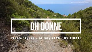
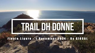
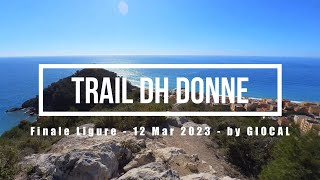
Iconic stage 4 of the Enduro World Series in 2013. Very loose terrain for a challenging and fun experience above some of the best views of the area.
Rocky sections, steep, gravely single track while riding along a proper balcony on the sea. Dh Donne is one of the most beautiful coast lines where stopping for a moment in order to enjoy the panorama is totally worth-it.

Featuring its iconic rocky, gravelly and dusty terrain, the DH Donne links 24H to DH Uomini. After a steep section on a wide track, you'll get on a short climb until the tiny peak from which you'll be able to catch one of the best views in the area. The trail keeps going on a tight and gravelly single track.

The section before merging into DH Uomini features steps, gravel and steep dusty bits.

source: ...
Access Info

Le Manie Area is reachable from the E80 highway accessing Spotorno. You'll need to take the SP8, then the SP45 towards Voze and you'll soon get to the top of the plateau.
Other option is getting out of the E80 in Finale Ligure, cross the town on the Aurelia (SS1) and driving up toward Le Manie on the SP45.

Disclaimer

Given its nature, the trail can change after weather happenings and season changes. Always pay attention.

Local Trail Association

Recent Activity on Trail

Past Week
  • 2 rides
  • 18 miles average
6 Months
  • 167 rides
  • 23 miles avg distance
All
  • 645 rides
  • Last: Jun 20, 2026
c1c2c3c4
January
February
March
April
May
June
July
August
September
October
November
December
update trails status or condition

DH Donne Trail Reports

statusdatedescription
May 20, 2026 @ 8:46am (Europe/Monaco)
May 19, 2026
May 7, 2026 @ 12:39am (Europe/Rome)
May 6, 2026
one of the best in finale imo, usually good even after rain or dry season, rocky enduro but still flowy
May 2, 2026 @ 12:40pm (Europe/Monaco)
May 2, 2026
Impossible to Ride smoothly - too many hikers its hilarious !!!
Apr 5, 2026 @ 11:36am (Europe/Monaco)
Apr 5, 2026
Mar 29, 2026 @ 11:39am (Europe/Monaco)
Mar 29, 2026
As always, best!
more »
Status:
on May 20, 2026
Dry
Avg: 4.22 (40 votes)
Your vote: 0

view (3,370)
close
3D
Trail Conditions
  • Unknown
  • Snow Groomed
  • Snow Packed
  • Snow Covered
  • Snow Cover Partial
  • Freeze/thaw Cycle
  • Icy
  • Prevalent Mud
  • Wet
  • Variable
  • Ideal
  • Dry
  • Very Dry
Trail Flow (Ridden Direction)
Trailforks scans users ridelogs to determine the most popular direction each trail is ridden. A good flowing trail network will have most trails flowing in a single direction according to their intension.
The colour categories are based on what percentage of riders are riding a trail in its intended direction.
  • > 96%
  • > 90%
  • > 80%
  • > 70%
  • > 50%
  • < 50%
  • bi-directional trail
  • no data
Trail Last Ridden
Trailforks scans ridelogs to determine the last time a trail was ridden.
  • < 2 days
  • < 1 week
  • < 2 weeks
  • < 1 month
  • < 6 months
  • > 6 months
Trail Ridden Direction
The intended direction a trail should be ridden.
  • Downhill Only
  • Downhill Primary
  • Both Directions
  • Uphill Primary
  • Uphill Only
  • One Direction
Contribute Details
Colors indicate trail is missing specified detail.
  • Description
  • Photos
  • Description & Photos
  • Videos
Trail Popularity ?
Trailforks scans ridelogs to determine which trails are ridden the most in the last 9 months. Trails are compared with nearby trails in the same city region with a possible 25 colour shades. Think of this as a heatmap, more rides = more kinetic energy = warmer colors.
  • most popular
  • popular
  • less popular
  • not popular
ATV/ORV/OHV Filter
Max Vehicle Width
inches
US Cell Coverage
Legend
cell carrier legend

Radar Time
Activity Recordings
Trailforks uses anonymized public activity data. ?
Activity Recordings
Trailforks uses anonymized public activity data. ?
Personal Heatmap
Activity Types
all / none
Options
2
Date range month
Winter Trails
Warning A routing network for winter maps does not exist. Selecting trails using the winter trails layer has been disabled.
Missing Trails
Most Popular
Least Popular
Trails are colored based on popularity. The more popular a trail is, the more red. Less popular trails trend towards green.
Jump Magnitude Heatmap
Heatmap of where riders jump on trails. Zoom in to see individual jumps, click circles to view jump details.
BC Backroad Status

Service Road Atlas is a free to use, community-driven service for viewing and creating reports on the numerous back-country service roads around B.C. and Alberta.

map legend
Slope Aspect
Direction the slope faces
Flat N NE E SE S SW W NW
Trails Deemphasized
Trails are shown in grey.
disable
Only show trails with no bike usage.
Enable
Suggested Layers
Based on selected activity type

    Save the current map location and zoom level as your default home location whenever this page is loaded.

    Save
        Directions to dh-donne trailhead (44.192010, 8.403550)

        Photos

        25 more »
        69 |
        Oct 18, 2025 @ 10:36am
        Oct 18, 2025
        70 |
        Oct 18, 2025 @ 10:36am
        Oct 18, 2025
        78 |
        Oct 18, 2025 @ 10:35am
        Oct 18, 2025
        101 |
        Sep 4, 2024 @ 7:19am
        Sep 4, 2024

        Videos

        12 more »
        Finale Ligure eMTBing - Trail DH Donne (iconic...
        9:19 | 286 | Jul 30, 2025 , Finale Ligure
        Finale Ligure eMTBing - Trail DH Donne
        9:18 | 171 | Dec 5, 2024 , Finale Ligure
        Finale Ligure eMTBing - Trail DH Donne...
        6:37 | 385 | Mar 12, 2023 , Finale Ligure
        Spotorno solo eMTB riding - Amazing panoramic...
        13:19 | 227 | Feb 21, 2022 , Finale Ligure

        Routes with this trail

        21 miles 2,112 ft 26
        Will do that in early may

        8 Reviews & Comments


        We hope you've been enjoying Trailforks!

        Create a FREE account to view trail comments and much more.

        • By andreamuzza & contributors
        • #122267 - 11,879 views

        Frequently Asked Questions About DH Donne

        Where is DH Donne located?
        DH Donne is located in Finale Outdoor Region, Finale Ligure, Italy. It is part of the Finale Outdoor Region trail network. The trailhead is located at coordinates 44.19201, 8.40355.
        How hard is DH Donne?
        DH Donne is rated as Red difficulty. The physical rating is Moderate. The average grade is 12.6%. The climb difficulty is rated Green.
        What is the elevation gain for DH Donne?
        The trail has 141 m of elevation descent. The elevation ranges from 147 m to 287 m.
        Is DH Donne a point to point trail?
        Yes, DH Donne is a point to point trail. The direction is Downhill Only. The trail type is singletrack.

        Hit the Trail

        Open in App

        Get this trail on your phone instantly.
        open trail in app

        Download Trail

        Save to wishlist, Garmin & download.
        save the trail

        Find Related Routes

        Find routes and users activities that include this trail.
        find routes for this trail

        You must enter a description before submitting.