more stats
4,547 ft
Distance
-850 ft
Descent
00:16:09
Avg time
-850 ft
Altitude change
96 ft
Altitude min
946 ft
Altitude max
946 ft
Altitude start
95 ft
Altitude end
-18.7%
Grade
-69.3%
Grade max
-3.4%
Grade min
4,547 ft
Distance down
00:16:09
Avg time

DH Uomini Details

  • Activities
    • Mountain Bike
    • E-Bike
  • Riding Area
    Finale Outdoor Region
    Finale Ligure
  • Ref Number
    #6
  • AKA
    DH Men
  • Difficulty Rating
  • Voted Difficulty
    Black (11 votes)
  • Local Popularity
    85 in Mountain Biking [+]
    • 80 in E-Biking
  • Global Ranking
    #219 in Mountain Biking [+]
    • #1624 in E-Biking
  • Trail Type
    Singletrack
  • Bike Type
    DH, AM
  • Direction
    Downhill Only
    Popular Direction Shown
  • Climb Difficulty
    Green
  • Physical Rating
    Moderate
  • Trail Visibility
    Always easy to follow
  • Season
    All-year round
  • Dogs Allowed
    Yes
  • eBike Allowed
    Yes up to Class 1
  • TTFs on Trail
    Drop, Rock Face, Rock Garden
  • Land Owner

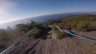
This trail is legend. Some of the most iconic pictures that depict Finale have been taken here. That sunset shot that make it look like the rider is dropping in the sea? Right here. Don’t get fooled though: this trail requires a high level of riding skills being one of the most challenging and risky.
Ask a guide to take you on it and tell you stories about this iconic trail.

source: ...
Access Info

Le Manie Area is reachable from the E80 highway accessing Spotorno. You'll need to take the SP8, then the SP45 towards Voze and you'll soon get to the top of the plateau. Other option is getting out of the E80 in Finale Ligure, cross the town on the Aurelia (SS1) and driving up toward Le Manie on the SP45.

Disclaimer

Given its loose terrain and despite the maintenance that often happens, the lines can change from one month to the following. Given its nature, the trail can change after weather happenings and season changes. Always pay attention

Local Trail Association

Recent Activity on Trail

Past Week
  • 3 rides
  • 17 miles average
6 Months
  • 173 rides
  • 23 miles avg distance
All
  • 818 rides
  • Last: Jun 18, 2026
c1c2c3c4
January
February
March
April
May
June
July
August
September
October
November
December
Status:
on May 23, 2026
Dry
Avg: 4.52 (65 votes)
Your vote: 0

view (4,940)
close
3D
Trail Conditions
  • Unknown
  • Snow Groomed
  • Snow Packed
  • Snow Covered
  • Snow Cover Partial
  • Freeze/thaw Cycle
  • Icy
  • Prevalent Mud
  • Wet
  • Variable
  • Ideal
  • Dry
  • Very Dry
Trail Flow (Ridden Direction)
Trailforks scans users ridelogs to determine the most popular direction each trail is ridden. A good flowing trail network will have most trails flowing in a single direction according to their intension.
The colour categories are based on what percentage of riders are riding a trail in its intended direction.
  • > 96%
  • > 90%
  • > 80%
  • > 70%
  • > 50%
  • < 50%
  • bi-directional trail
  • no data
Trail Last Ridden
Trailforks scans ridelogs to determine the last time a trail was ridden.
  • < 2 days
  • < 1 week
  • < 2 weeks
  • < 1 month
  • < 6 months
  • > 6 months
Trail Ridden Direction
The intended direction a trail should be ridden.
  • Downhill Only
  • Downhill Primary
  • Both Directions
  • Uphill Primary
  • Uphill Only
  • One Direction
Contribute Details
Colors indicate trail is missing specified detail.
  • Description
  • Photos
  • Description & Photos
  • Videos
Trail Popularity ?
Trailforks scans ridelogs to determine which trails are ridden the most in the last 9 months. Trails are compared with nearby trails in the same city region with a possible 25 colour shades. Think of this as a heatmap, more rides = more kinetic energy = warmer colors.
  • most popular
  • popular
  • less popular
  • not popular
ATV/ORV/OHV Filter
Max Vehicle Width
inches
US Cell Coverage
Legend
cell carrier legend

Radar Time
Activity Recordings
Trailforks uses anonymized public activity data. ?
Activity Recordings
Trailforks uses anonymized public activity data. ?
Personal Heatmap
Activity Types
all / none
Options
2
Date range month
Winter Trails
Warning A routing network for winter maps does not exist. Selecting trails using the winter trails layer has been disabled.
Missing Trails
Most Popular
Least Popular
Trails are colored based on popularity. The more popular a trail is, the more red. Less popular trails trend towards green.
Jump Magnitude Heatmap
Heatmap of where riders jump on trails. Zoom in to see individual jumps, click circles to view jump details.
BC Backroad Status

Service Road Atlas is a free to use, community-driven service for viewing and creating reports on the numerous back-country service roads around B.C. and Alberta.

map legend
Slope Aspect
Direction the slope faces
Flat N NE E SE S SW W NW
Trails Deemphasized
Trails are shown in grey.
disable
Only show trails with no bike usage.
Enable
Suggested Layers
Based on selected activity type

    Save the current map location and zoom level as your default home location whenever this page is loaded.

    Save
        Directions to dh-uomini trailhead (44.192010, 8.403550)

        Photos

        165 more »
        45 |
        May 13, 2026 @ 12:58am
        May 13, 2026
        60 |
        May 13, 2026 @ 12:58am
        May 13, 2026
        54 |
        May 13, 2026 @ 12:58am
        May 13, 2026
        55 |
        Feb 4, 2026 @ 8:33am
        Feb 4, 2026

        Videos

        23 more »
        youtuber Men's DH Finale EWS 2018
        5:39 | 1993 | Oct 26, 2018 , Finale Ligure
        Super ENDURKO pri mori vo Finale Ligure je...
        24:25 | 256 | Apr 6, 2025 , Finale Ligure
        DH Uomini - Finale Ligure / 11.10.2024
        8:03 | 393 | Oct 16, 2024 , Finale Ligure
        MTB Enduro trail above the sea | Finale Ligure...
        4:26 | 410 | May 6, 2024 , Finale Ligure

        Routes with this trail

        2.0 19 miles 1,407 ft 5 Shuttled
        All mountain trip starting at nato base and finishing at the level of the sea!
        19 miles 1,314 ft 7 Shuttled
        All mountain trip starting at nato base and finishing at the level of the sea!
        18 miles 3,948 ft 11
        No idea if this is going to work on a bike...

        10 Reviews & Comments


        We hope you've been enjoying Trailforks!

        Create a FREE account to view trail comments and much more.

        Frequently Asked Questions About DH Uomini

        Where is DH Uomini located?
        DH Uomini is located in Finale Outdoor Region, Finale Ligure, Italy. It is part of the Finale Outdoor Region trail network. The trailhead is located at coordinates 44.19201, 8.40355.
        How hard is DH Uomini?
        DH Uomini is rated as Black difficulty. The physical rating is Moderate. The average grade is 18.7%. The climb difficulty is rated Green.
        What is the elevation gain for DH Uomini?
        The trail has 259 m of elevation descent. The elevation ranges from 29 m to 288 m.
        Is DH Uomini a point to point trail?
        Yes, DH Uomini is a point to point trail. The direction is Downhill Only. The trail type is singletrack.

        Hit the Trail

        Open in App

        Get this trail on your phone instantly.
        open trail in app

        Download Trail

        Save to wishlist, Garmin & download.
        save the trail

        Find Related Routes

        Find routes and users activities that include this trail.
        find routes for this trail

        You must enter a description before submitting.