more stats
2.2 miles
Distance
-2,160 ft
Descent
00:30:31
Avg time
-2,160 ft
Altitude change
2,592 ft
Altitude min
4,752 ft
Altitude max
4,752 ft
Altitude start
2,592 ft
Altitude end
-18.8%
Grade
-66.3%
Grade max
1.9%
Grade min
82 ft
Distance climb
2 miles
Distance down
39 ft
Distance flat
00:30:31
Avg time

Diabolika Details

  • Activities
    • Mountain Bike
    • E-Bike
    • Hike
    • Trail Running
  • Riding Area
  • Difficulty Rating
  • Voted Difficulty
    Red (1 vote)
  • Local Popularity
    80 in Mountain Biking [+]
    • 75 in E-Biking
    • 5 in Trail Running
    • 5 in Hiking
  • Global Ranking
    #14674 in Mountain Biking [+]
    • #301 in E-Biking
    • #140756 in Trail Running
    • #135096 in Hiking
  • Trail Type
    Singletrack
  • Bike Type
    DH, AM
  • Direction
    Downhill Only
    Popular Direction Shown
  • Physical Rating
    Moderate
  • Trail Visibility
    Always easy to follow
  • eBike Allowed
    Yes up to Class 1
  • Year Opened
    2022

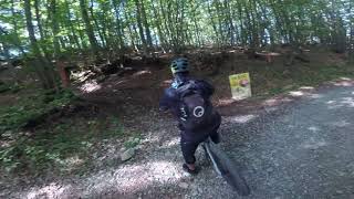
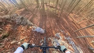
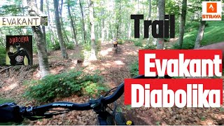
Trail naturale nel bosco, primo tratto più tecnico e ripido, seconda e terza parte più flow nel bosco ad alto fusto. Breve tratto con difficoltà maggiore all'inizio, bypassabile a sinistra. Segnalato da piccole frecce di legno.

Access Info

Da Ballone o da Bellasola diverse possibilità. Possibile anche dal Passo del Ticchiano

Recent Activity on Trail

Past Week
  • 0 rides
  •  
6 Months
  • 0 rides
  •  
All
  • 8 rides
  • Last: Nov 30, 2025
c1c2c3c4
January
February
March
April
May
June
July
August
September
October
November
December
update trails status or condition

Diabolika Trail Reports

statusdatedescription
Aug 31, 2025 @ 10:13am
Aug 31, 2025
Umido ma non fangoso. Terreno con buona tenuta. La prima parte, più ripida, richiede attenzione e controllo. Bellissimo
Jul 8, 2025 @ 10:33am
Jul 8, 2025
Al top, spazzolato è rasato, vi aspetta per una bomba di adrenalina.
Jul 8, 2025 @ 10:27am
Jul 8, 2025
Completamente pulito e spazzolato, è uno spettacolo, tutto da godere
Aug 18, 2024 @ 2:17am
Aug 18, 2024
Nov 6, 2022 @ 3:39am
Nov 6, 2022
La prima metà con scarso grip: molto coperta da foglie, con terreno bagnato sotto. Condizioni migliori nella seconda metà. Tornerò con...
more »
Status:
on Aug 31, 2025
Wet
Avg: 4.1 (4 votes)
Your vote: 0

view (49)
close
3D
Trail Conditions
  • Unknown
  • Snow Groomed
  • Snow Packed
  • Snow Covered
  • Snow Cover Partial
  • Freeze/thaw Cycle
  • Icy
  • Prevalent Mud
  • Wet
  • Variable
  • Ideal
  • Dry
  • Very Dry
Trail Flow (Ridden Direction)
Trailforks scans users ridelogs to determine the most popular direction each trail is ridden. A good flowing trail network will have most trails flowing in a single direction according to their intension.
The colour categories are based on what percentage of riders are riding a trail in its intended direction.
  • > 96%
  • > 90%
  • > 80%
  • > 70%
  • > 50%
  • < 50%
  • bi-directional trail
  • no data
Trail Last Ridden
Trailforks scans ridelogs to determine the last time a trail was ridden.
  • < 2 days
  • < 1 week
  • < 2 weeks
  • < 1 month
  • < 6 months
  • > 6 months
Trail Ridden Direction
The intended direction a trail should be ridden.
  • Downhill Only
  • Downhill Primary
  • Both Directions
  • Uphill Primary
  • Uphill Only
  • One Direction
Contribute Details
Colors indicate trail is missing specified detail.
  • Description
  • Photos
  • Description & Photos
  • Videos
Trail Popularity ?
Trailforks scans ridelogs to determine which trails are ridden the most in the last 9 months. Trails are compared with nearby trails in the same city region with a possible 25 colour shades. Think of this as a heatmap, more rides = more kinetic energy = warmer colors.
  • most popular
  • popular
  • less popular
  • not popular
ATV/ORV/OHV Filter
Max Vehicle Width
inches
US Cell Coverage
Legend
cell carrier legend

Radar Time
Activity Recordings
Trailforks uses anonymized public activity data. ?
Activity Recordings
Trailforks uses anonymized public activity data. ?
Personal Heatmap
Activity Types
all / none
Options
2
Date range month
Winter Trails
Warning A routing network for winter maps does not exist. Selecting trails using the winter trails layer has been disabled.
Missing Trails
Most Popular
Least Popular
Trails are colored based on popularity. The more popular a trail is, the more red. Less popular trails trend towards green.
Jump Magnitude Heatmap
Heatmap of where riders jump on trails. Zoom in to see individual jumps, click circles to view jump details.
BC Backroad Status

Service Road Atlas is a free to use, community-driven service for viewing and creating reports on the numerous back-country service roads around B.C. and Alberta.

map legend
Slope Aspect
Direction the slope faces
Flat N NE E SE S SW W NW
Trails Deemphasized
Trails are shown in grey.
disable
Only show trails with no bike usage.
Enable
Suggested Layers
Based on selected activity type

    Save the current map location and zoom level as your default home location whenever this page is loaded.

    Save
        Directions to diabolika trailhead (44.452430, 10.135290)

        Photos

        1 more »
        77 |
        Nov 8, 2022 @ 4:53am
        Nov 8, 2022

        Videos

        3 more »
        Diabolika, Corniglio
        13:07 | 212 | Oct 10, 2023 , Corniglio
        Ballone - Diabolika - MTB POV
        11:50 | 248 | Nov 7, 2022 , Corniglio
        Trail Diabolika e Evakant con bagno finale
        13:28 | 243 | Aug 14, 2022 , Corniglio

        2 Reviews & Comments


        We hope you've been enjoying Trailforks!

        Create a FREE account to view trail comments and much more.

        • By CapatazTF Pro & contributors
        • #528836 - 1,412 views

        Frequently Asked Questions About Diabolika

        Where is Diabolika located?
        Diabolika is located in Corniglio, Italy. It is part of the Corniglio trail network. The trailhead is located at coordinates 44.45243, 10.13529.
        How hard is Diabolika?
        Diabolika is rated as Red difficulty. The physical rating is Moderate. The average grade is 18.8%.
        What is the elevation gain for Diabolika?
        The trail has 658 m of elevation descent. The elevation ranges from 790 m to 1,448 m.
        Is Diabolika a point to point trail?
        Yes, Diabolika is a point to point trail. The direction is Downhill Only. The trail type is singletrack.

        Hit the Trail

        Open in App

        Get this trail on your phone instantly.
        open trail in app

        Download Trail

        Save to wishlist, Garmin & download.
        save the trail

        Find Related Routes

        Find routes and users activities that include this trail.
        find routes for this trail

        You must enter a description before submitting.