more stats
1,804 ft
Distance
-434 ft
Descent
00:10:47
Avg time
-434 ft
Altitude change
500 ft
Altitude min
934 ft
Altitude max
934 ft
Altitude start
502 ft
Altitude end
-24%
Grade
-91.8%
Grade max
-3.6%
Grade min
1,804 ft
Distance down
00:10:47
Avg time

Dig This Details

  • Activities
    • Mountain Bike
  • Riding Area
  • Difficulty Rating
  • Voted Difficulty
    Double Black Diamond (6 votes)
  • Local Popularity
    100 in Mountain Biking
  • Global Ranking
    #9572 in Mountain Biking
  • Trail Type
    Singletrack
  • Bike Type
    DH, AM
  • Direction
    Downhill Only
    Popular Direction Shown
  • TTFs on Trail
    Drop, Gap Jump, Rock Garden

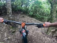
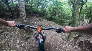
Very much in the same flavor as neighboring Pavlova, this is a steep feral track through beech forest. Just as steep as Pavlova, but with a more purpose-built rather than natural feel, it's a shade lower in difficulty. But don't let the relatively mellow start fool you. Along with Year Gnar, Morepork, Topa Topa and Trickle Falls, this is one of Wellington's most demanding technical tracks. Only those with confidence, skill, and a good bike need apply.

Local Trail Association

Recent Activity on Trail

Past Week
  • 0 rides
  •  
6 Months
  • 20 rides
  • 14 miles avg distance
All
  • 59 rides
  • Last: May 30, 2026
c1c2c3c4
January
February
March
April
May
June
July
August
September
October
November
December
update trails status or condition

Dig This Trail Reports

statusdatedescription
Feb 6, 2024 @ 1:08am
Feb 6, 2024
All good but beware the lip of the gap jump at the bottom of the trail has been built up quite a lot. Very easy to overshoot the landing now - or...
Jan 12, 2024 @ 6:04pm
Jan 12, 2024
Nov 13, 2023 @ 8:03pm
Nov 13, 2023
Running mint
Oct 20, 2023 @ 12:44pm
Oct 20, 2023
Trail open again after winter closure. Please continue to keep off the trail after any heavy rain.
Oct 3, 2023 @ 8:01pm
Oct 3, 2023
Trail shut down due to being rutted cause people hitting it in the wet Minor erosion (trail braiding, small ruts developing, brake bumps)
more »
Status:
on Feb 6, 2024
Dry
Avg: 3.79 (5 votes)
Your vote: 0

view (394)
close
3D
Trail Conditions
  • Unknown
  • Snow Groomed
  • Snow Packed
  • Snow Covered
  • Snow Cover Partial
  • Freeze/thaw Cycle
  • Icy
  • Prevalent Mud
  • Wet
  • Variable
  • Ideal
  • Dry
  • Very Dry
Trail Flow (Ridden Direction)
Trailforks scans users ridelogs to determine the most popular direction each trail is ridden. A good flowing trail network will have most trails flowing in a single direction according to their intension.
The colour categories are based on what percentage of riders are riding a trail in its intended direction.
  • > 96%
  • > 90%
  • > 80%
  • > 70%
  • > 50%
  • < 50%
  • bi-directional trail
  • no data
Trail Last Ridden
Trailforks scans ridelogs to determine the last time a trail was ridden.
  • < 2 days
  • < 1 week
  • < 2 weeks
  • < 1 month
  • < 6 months
  • > 6 months
Trail Ridden Direction
The intended direction a trail should be ridden.
  • Downhill Only
  • Downhill Primary
  • Both Directions
  • Uphill Primary
  • Uphill Only
  • One Direction
Contribute Details
Colors indicate trail is missing specified detail.
  • Description
  • Photos
  • Description & Photos
  • Videos
Trail Popularity ?
Trailforks scans ridelogs to determine which trails are ridden the most in the last 9 months. Trails are compared with nearby trails in the same city region with a possible 25 colour shades. Think of this as a heatmap, more rides = more kinetic energy = warmer colors.
  • most popular
  • popular
  • less popular
  • not popular
ATV/ORV/OHV Filter
Max Vehicle Width
inches
US Cell Coverage
Legend
cell carrier legend

Radar Time
Activity Recordings
Trailforks uses anonymized public activity data. ?
Activity Recordings
Trailforks uses anonymized public activity data. ?
Personal Heatmap
Activity Types
all / none
Options
2
Date range month
Winter Trails
Warning A routing network for winter maps does not exist. Selecting trails using the winter trails layer has been disabled.
Missing Trails
Most Popular
Least Popular
Trails are colored based on popularity. The more popular a trail is, the more red. Less popular trails trend towards green.
Jump Magnitude Heatmap
Heatmap of where riders jump on trails. Zoom in to see individual jumps, click circles to view jump details.
BC Backroad Status

Service Road Atlas is a free to use, community-driven service for viewing and creating reports on the numerous back-country service roads around B.C. and Alberta.

map legend
Slope Aspect
Direction the slope faces
Flat N NE E SE S SW W NW
Trails Deemphasized
Trails are shown in grey.
disable
Only show trails with no bike usage.
Enable
Suggested Layers
Based on selected activity type

    Save the current map location and zoom level as your default home location whenever this page is loaded.

    Save
        Directions to dig-this trailhead (-41.235470, 174.933850)

        Photos

        No photos have been added for Dig This yet, add a photo.

        Videos

        2 more »
        youtuber Dig This **BRAND NEW** @ Wainuiomata Trail Park
        3:21 | 433 | Jan 1, 2023 , Wainuiomata
        youtuber The Singletrack Surfer Vlog #4. New trail 1st...
        8:44 | 260 | Feb 6, 2023 , Wainuiomata
        youtuber Dig This **BRAND NEW** @ Wainuiomata Trail Park
        3:21 | 198 | Feb 5, 2023 , Wainuiomata

        Routes with this trail

        21 miles 5,052 ft 28 Loop Race
        egfhwb UILYGFHWIue4rghilwue4rghyilweu4ghyrlwIJ4GYI

        Reviews / Comments

        No reviews yet, be the first to write a review or ask a question.
        Use trail reports to comment on trail conditions.


        We hope you've been enjoying Trailforks!

        Create a FREE account to view trail comments and much more.

        • By donalduckTF Pro & contributors
        • #604656 - 1,166 views

        Frequently Asked Questions About Dig This

        Where is Dig This located?
        Dig This is located in Wainuiomata, New Zealand. It is part of the Wainuiomata trail network. The trailhead is located at coordinates -41.23547, 174.93385.
        How hard is Dig This?
        Dig This is rated as Black Diamond difficulty. The average grade is 24%.
        What is the elevation gain for Dig This?
        The trail has 434 ft of elevation descent. The elevation ranges from 500 ft to 934 ft.
        Is Dig This a point to point trail?
        Yes, Dig This is a point to point trail. The direction is Downhill Only. The trail type is singletrack.

        Hit the Trail

        Open in App

        Get this trail on your phone instantly.
        open trail in app

        Download Trail

        Save to wishlist, Garmin & download.
        save the trail

        Find Related Routes

        Find routes and users activities that include this trail.
        find routes for this trail

        You must enter a description before submitting.