more stats
945 ft
Distance
-230 ft
Descent
00:04:21
Avg time
-232 ft
Altitude change
1,210 ft
Altitude min
1,442 ft
Altitude max
1,442 ft
Altitude start
1,211 ft
Altitude end
-24.5%
Grade
-52.8%
Grade max
-9.3%
Grade min
945 ft
Distance down
00:04:21
Avg time

Digger Details

  • Activities
    • Mountain Bike
    • E-Bike
    • Hike
    • Trail Running
  • Riding Area
    Mount Fromme
    North Vancouver, British Columbia
  • Difficulty Rating
  • Voted Difficulty
    Double Black Diamond (10 votes)
  • Local Popularity
    50 in Mountain Biking [+]
    • 40 in E-Biking
    • 40 in Trail Running
    • 60 in Hiking
  • Global Ranking
    #28066 in Mountain Biking [+]
    • #40608 in E-Biking
    • #34932 in Trail Running
    • #3094 in Hiking
  • Trail Type
    Singletrack
  • Bike Type
    DH
  • Dogs Allowed
    Yes
  • eBike Allowed
  • TTFs on Trail
    Drop, Skinny
  • Land Owner
    District of North Vancouver

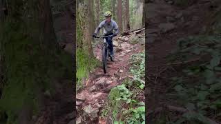
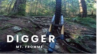
Technical trail containing many steep natural and man-made TTFs. The TTFs are very skinny and challenging. Not a beginner trail.

Digger is a steep, old school, techy, VERY slow and precise trail. If you want fast flow with jumps and drops, this totally is not the trail for you. If you like precise, start and stop, slow trials-like technical, hit it Avoid taking new riders and those without a good rear wheel sense down it.

Access Info

Accessed off Baden Powell, exciting at Braemar road close to the powerlines.

Trail Supporters
Local Trail Association

Recent Activity on Trail

Past Week
  • 0 rides
  •  
6 Months
  • 10 rides
  • 8 miles avg distance
All
  • 338 rides
  • Last: May 27, 2026
c1c2c3c4
January
February
March
April
May
June
July
August
September
October
November
December
update trails status or condition

Digger Trail Reports

statusdatedescription
Jun 1, 2026 @ 10:42am (Pacific/Auckland)
May 31, 2026
Shore tech at its finest. An awesome short tech trail that feels longer.
May 9, 2026 @ 1:19pm (America/Vancouver)
May 9, 2026
Jan 2, 2026 @ 1:46pm (Pacific/Auckland)
Jan 1, 2026
Nov 14, 2025 @ 11:51am (Pacific/Auckland)
Nov 13, 2025
Recent rain has the rocks a little too slick in some sections. Other than that the trail is doing just fine!
Jun 10, 2025 @ 6:14pm
Jun 10, 2025
more »
Status:
on Jun 1, 2026
Ideal
Avg: 4.46 (35 votes)
Your vote: 0

view (1,723)
close
3D
Trail Conditions
  • Unknown
  • Snow Groomed
  • Snow Packed
  • Snow Covered
  • Snow Cover Partial
  • Freeze/thaw Cycle
  • Icy
  • Prevalent Mud
  • Wet
  • Variable
  • Ideal
  • Dry
  • Very Dry
Trail Flow (Ridden Direction)
Trailforks scans users ridelogs to determine the most popular direction each trail is ridden. A good flowing trail network will have most trails flowing in a single direction according to their intension.
The colour categories are based on what percentage of riders are riding a trail in its intended direction.
  • > 96%
  • > 90%
  • > 80%
  • > 70%
  • > 50%
  • < 50%
  • bi-directional trail
  • no data
Trail Last Ridden
Trailforks scans ridelogs to determine the last time a trail was ridden.
  • < 2 days
  • < 1 week
  • < 2 weeks
  • < 1 month
  • < 6 months
  • > 6 months
Trail Ridden Direction
The intended direction a trail should be ridden.
  • Downhill Only
  • Downhill Primary
  • Both Directions
  • Uphill Primary
  • Uphill Only
  • One Direction
Contribute Details
Colors indicate trail is missing specified detail.
  • Description
  • Photos
  • Description & Photos
  • Videos
Trail Popularity ?
Trailforks scans ridelogs to determine which trails are ridden the most in the last 9 months. Trails are compared with nearby trails in the same city region with a possible 25 colour shades. Think of this as a heatmap, more rides = more kinetic energy = warmer colors.
  • most popular
  • popular
  • less popular
  • not popular
ATV/ORV/OHV Filter
Max Vehicle Width
inches
US Cell Coverage
Legend
cell carrier legend

Radar Time
Activity Recordings
Trailforks uses anonymized public activity data. ?
Activity Recordings
Trailforks uses anonymized public activity data. ?
Personal Heatmap
Activity Types
all / none
Options
2
Date range month
Winter Trails
Warning A routing network for winter maps does not exist. Selecting trails using the winter trails layer has been disabled.
Missing Trails
Most Popular
Least Popular
Trails are colored based on popularity. The more popular a trail is, the more red. Less popular trails trend towards green.
Jump Magnitude Heatmap
Heatmap of where riders jump on trails. Zoom in to see individual jumps, click circles to view jump details.
BC Backroad Status

Service Road Atlas is a free to use, community-driven service for viewing and creating reports on the numerous back-country service roads around B.C. and Alberta.

map legend
Slope Aspect
Direction the slope faces
Flat N NE E SE S SW W NW
Trails Deemphasized
Trails are shown in grey.
disable
Only show trails with no bike usage.
Enable
Suggested Layers
Based on selected activity type

    Save the current map location and zoom level as your default home location whenever this page is loaded.

    Save
        Directions to digger trailhead (49.350900, -123.058800)

        Photos

        25 more »
        2,644 |
        Jun 14, 2013 @ 3:08pm
        Jun 14, 2013
        1,994 |
        Jun 14, 2013 @ 3:07pm
        Jun 14, 2013
        363 |
        Dec 11, 2020 @ 3:24pm
        Dec 11, 2020
        1,375 |
        Feb 29, 2004 @ 7:43pm
        Feb 29, 2004

        Videos

        14 more »
        youtuber Yup, The North Shore is Still Insane
        12:51 | 1632 | Oct 14, 2019 , North Vancouver
        Skinny to small drop on Upper Digger
        0:13 | 34 | Jan 1, 2026 , North Vancouver
        Upper // Lower Digger - Mt. Fromme, North...
        5:22 | 222 | Sep 1, 2024 , North Vancouver
        youtuber “Old School” MTB Trails - Digger and Lower...
        7:19 | 802 | May 6, 2021 , North Vancouver

        Trail Lists

        Routes with this trail

        5.0 6 miles 1,816 ft 32 Loop
        Get a taste of old school North Shore trails with this tech gnar route. Best served dry unless you want...
        3 miles 908 ft 7
        After climbing up , , //www.trailforks.com/trails/st-marys/]St Mary's Connector, and maybe hike a biking ,...
        5 miles 1,377 ft 6
        This is a fun top to bottom run down Fromme. Trails: , , , St. Mary, , BP, .

        20 Reviews & Comments


        We hope you've been enjoying Trailforks!

        Create a FREE account to view trail comments and much more.

        • By canadakaTF Pro Trailforks & contributors
        • #183 - 19,510 views

        Frequently Asked Questions About Digger

        Where is Digger located?
        Digger is located in Mount Fromme, North Vancouver, British Columbia, Canada. It is part of the Mount Fromme trail network. The trailhead is located at coordinates 49.3509, -123.0588.
        How hard is Digger?
        Digger is rated as Double Black Diamond difficulty. The average grade is 24.5%.
        What is the elevation gain for Digger?
        The trail has 70 m of elevation descent. The elevation ranges from 369 m to 439 m.
        How long is Digger?
        Digger is 288.0 m long. The trail type is singletrack.

        Hit the Trail

        Open in App

        Get this trail on your phone instantly.
        open trail in app

        Download Trail

        Save to wishlist, Garmin & download.
        save the trail

        Find Related Routes

        Find routes and users activities that include this trail.
        find routes for this trail

        You must enter a description before submitting.