more stats
1,611 ft
Distance
-153 ft
Descent
00:03:27
Avg time
-153 ft
Altitude change
749 ft
Altitude min
902 ft
Altitude max
902 ft
Altitude start
748 ft
Altitude end
-9.5%
Grade
-29.8%
Grade max
-1.3%
Grade min
1,611 ft
Distance down
00:03:27
Avg time

Dijagonala Details

  • Activities
    • Mountain Bike
    • E-Bike
    • Hike
    • Trail Running
  • Riding Area
    Perun
    Omis
  • Difficulty Rating
  • Global Ranking
    #125774 in Mountain Biking [+]
    • #104804 in E-Biking
    • #135526 in Trail Running
    • #129359 in Hiking
  • Trail Type
    Singletrack
  • Bike Type
    DH, AM, XC
  • Direction
    Downhill Only
    Popular Direction Shown
  • Climb Difficulty
    Green
  • Physical Rating
    Easy
  • Trail Visibility
    Always easy to follow
  • Season
    All year
  • Family Friendly
    Yes
  • Dogs Allowed
    Yes
  • eBike Allowed
    Yes up to Class 1
  • TTFs on Trail
    Berm, Jump, Roller Coaster
  • Ride in Rain
    Yes
  • Year Opened
    2019

Begins as natural singletrack with the couple of small jumps leading into the roller coaster section with jumps and berms.
Jumps are tabletops and doubles, riders can roll over them.

Access Info

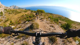
Follow gravel road in the foot of the mountain. Halfway through you'll notice singletrack with some small jumps on the side of the road looking at the coast.

Local Trail Association

Recent Activity on Trail

Past Week
  • 0 rides
  •  
6 Months
  • 7 rides
  • 11 miles avg distance
All
  • 50 rides
  • Last: May 13, 2026
c1c2c3c4
January
February
March
April
May
June
July
August
September
October
November
December
Status:
on Apr 29, 2026
Ideal
Avg: 4.39 (11 votes)
Your vote: 0

view (0)
close
3D
Trail Conditions
  • Unknown
  • Snow Groomed
  • Snow Packed
  • Snow Covered
  • Snow Cover Partial
  • Freeze/thaw Cycle
  • Icy
  • Prevalent Mud
  • Wet
  • Variable
  • Ideal
  • Dry
  • Very Dry
Trail Flow (Ridden Direction)
Trailforks scans users ridelogs to determine the most popular direction each trail is ridden. A good flowing trail network will have most trails flowing in a single direction according to their intension.
The colour categories are based on what percentage of riders are riding a trail in its intended direction.
  • > 96%
  • > 90%
  • > 80%
  • > 70%
  • > 50%
  • < 50%
  • bi-directional trail
  • no data
Trail Last Ridden
Trailforks scans ridelogs to determine the last time a trail was ridden.
  • < 2 days
  • < 1 week
  • < 2 weeks
  • < 1 month
  • < 6 months
  • > 6 months
Trail Ridden Direction
The intended direction a trail should be ridden.
  • Downhill Only
  • Downhill Primary
  • Both Directions
  • Uphill Primary
  • Uphill Only
  • One Direction
Contribute Details
Colors indicate trail is missing specified detail.
  • Description
  • Photos
  • Description & Photos
  • Videos
Trail Popularity ?
Trailforks scans ridelogs to determine which trails are ridden the most in the last 9 months. Trails are compared with nearby trails in the same city region with a possible 25 colour shades. Think of this as a heatmap, more rides = more kinetic energy = warmer colors.
  • most popular
  • popular
  • less popular
  • not popular
ATV/ORV/OHV Filter
Max Vehicle Width
inches
US Cell Coverage
Legend
cell carrier legend

Radar Time
Activity Recordings
Trailforks uses anonymized public activity data. ?
Activity Recordings
Trailforks uses anonymized public activity data. ?
Personal Heatmap
Activity Types
all / none
Options
2
Date range month
Winter Trails
Warning A routing network for winter maps does not exist. Selecting trails using the winter trails layer has been disabled.
Missing Trails
Most Popular
Least Popular
Trails are colored based on popularity. The more popular a trail is, the more red. Less popular trails trend towards green.
Jump Magnitude Heatmap
Heatmap of where riders jump on trails. Zoom in to see individual jumps, click circles to view jump details.
BC Backroad Status

Service Road Atlas is a free to use, community-driven service for viewing and creating reports on the numerous back-country service roads around B.C. and Alberta.

map legend
Slope Aspect
Direction the slope faces
Flat N NE E SE S SW W NW
Trails Deemphasized
Trails are shown in grey.
disable
Only show trails with no bike usage.
Enable
Suggested Layers
Based on selected activity type

    Save the current map location and zoom level as your default home location whenever this page is loaded.

    Save
        Directions to dijagonala trailhead (43.448910, 16.661720)

        Photos

        8 more »
        136 |
        Aug 26, 2022 @ 12:03am
        Aug 26, 2022
        253 |
        Apr 8, 2021 @ 6:59am
        Apr 8, 2021
        191 |
        Nov 21, 2020 @ 4:29am
        Nov 21, 2020
        175 |
        Nov 21, 2020 @ 4:29am
        Nov 21, 2020

        Videos

        1 more »
        Omiš enduro trails on Perun - shuttle part 2/3
        15:03 | 243 | Nov 29, 2021 , Omis

        2 Reviews & Comments


        We hope you've been enjoying Trailforks!

        Create a FREE account to view trail comments and much more.

        Nearby Trails

        • By oldpathsnewtrails & contributors
        • #189770 - 2,396 views

        Frequently Asked Questions About Dijagonala

        Where is Dijagonala located?
        Dijagonala is located in Perun, Omis, Croatia. It is part of the Perun trail network. The trailhead is located at coordinates 43.44891, 16.66172.
        How hard is Dijagonala?
        Dijagonala is rated as Blue difficulty. The physical rating is Easy. The average grade is 9.5%. The climb difficulty is rated Green.
        What is the elevation gain for Dijagonala?
        The trail has 153 ft of elevation descent. The elevation ranges from 749 ft to 902 ft.
        Is Dijagonala a point to point trail?
        Yes, Dijagonala is a point to point trail. The direction is Downhill Only. The trail type is singletrack.

        Hit the Trail

        Open in App

        Get this trail on your phone instantly.
        open trail in app

        Download Trail

        Save to wishlist, Garmin & download.
        save the trail

        Find Related Routes

        Find routes and users activities that include this trail.
        find routes for this trail

        You must enter a description before submitting.