more stats
2,119 ft
Distance
-363 ft
Descent
00:04:34
Avg time
-363 ft
Altitude change
1,011 ft
Altitude min
1,375 ft
Altitude max
1,375 ft
Altitude start
1,010 ft
Altitude end
-17.1%
Grade
-50.6%
Grade max
-5.1%
Grade min
2,119 ft
Distance down
00:04:34
Avg time

Dimas 1 & 2 Details

  • Activities
    • Mountain Bike
    • E-Bike
    • Hike
    • Trail Running
  • Riding Area
  • Difficulty Rating
  • Voted Difficulty
    Blue (9 votes)
  • Local Popularity
    35 in Mountain Biking [+]
    • 50 in E-Biking
    • 80 in Trail Running
    • 40 in Hiking
  • Global Ranking
    #58700 in Mountain Biking [+]
    • #75028 in E-Biking
    • #72736 in Trail Running
    • #114855 in Hiking
  • Trail Type
    Singletrack
  • Bike Type
    DH, AM, XC
  • Direction
    Downhill Primary
    Popular Direction Shown
  • Climb Difficulty
    Double Black Diamond
  • Physical Rating
    Hard
  • Trail Visibility
    Always easy to follow
  • Dogs Allowed
    Yes
  • eBike Allowed
    Yes up to Class 1
  • TTFs on Trail
    Jump
  • Ride in Rain
    Yes
  • Land Owner
    Instituto da Conservação da Natureza e das Florestas, I.P.

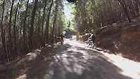
The name Dimas, it´s in memory of the Trail Builder, who made the trail, and pass away with cancer, years ago.

Technical blue or Dark blue, trail.

Local Trail Association

Recent Activity on Trail

Past Week
  • 1 rides
  • 9 miles average
6 Months
  • 1 rides
  • 9 miles avg distance
All
  • 109 rides
  • Last: Jun 14, 2026
c1c2c3c4
January
February
March
April
May
June
July
August
September
October
November
December
update trails status or condition

Dimas 1 & 2 Trail Reports

statusdatedescription
Oct 20, 2025 @ 11:54am (Europe/Lisbon)
Oct 20, 2025
Closed
Apr 22, 2025 @ 11:30pm
Apr 22, 2025
Trail close for heavy maintenance due to the storm.
Apr 22, 2025 @ 11:22pm
Apr 22, 2025
Works happening because of storm Martinho. First and second section blocked with tones of fall trees.
Mar 2, 2025 @ 8:36am
Mar 2, 2025
Feb 13, 2025 @ 9:43am
Feb 13, 2025
more »
Status:
on Oct 20, 2025
Avg: 4.49 (12 votes)
Your vote: 0

view (1,296)
close
3D
Trail Conditions
  • Unknown
  • Snow Groomed
  • Snow Packed
  • Snow Covered
  • Snow Cover Partial
  • Freeze/thaw Cycle
  • Icy
  • Prevalent Mud
  • Wet
  • Variable
  • Ideal
  • Dry
  • Very Dry
Trail Flow (Ridden Direction)
Trailforks scans users ridelogs to determine the most popular direction each trail is ridden. A good flowing trail network will have most trails flowing in a single direction according to their intension.
The colour categories are based on what percentage of riders are riding a trail in its intended direction.
  • > 96%
  • > 90%
  • > 80%
  • > 70%
  • > 50%
  • < 50%
  • bi-directional trail
  • no data
Trail Last Ridden
Trailforks scans ridelogs to determine the last time a trail was ridden.
  • < 2 days
  • < 1 week
  • < 2 weeks
  • < 1 month
  • < 6 months
  • > 6 months
Trail Ridden Direction
The intended direction a trail should be ridden.
  • Downhill Only
  • Downhill Primary
  • Both Directions
  • Uphill Primary
  • Uphill Only
  • One Direction
Contribute Details
Colors indicate trail is missing specified detail.
  • Description
  • Photos
  • Description & Photos
  • Videos
Trail Popularity ?
Trailforks scans ridelogs to determine which trails are ridden the most in the last 9 months. Trails are compared with nearby trails in the same city region with a possible 25 colour shades. Think of this as a heatmap, more rides = more kinetic energy = warmer colors.
  • most popular
  • popular
  • less popular
  • not popular
ATV/ORV/OHV Filter
Max Vehicle Width
inches
US Cell Coverage
Legend
cell carrier legend

Radar Time
Activity Recordings
Trailforks uses anonymized public activity data. ?
Activity Recordings
Trailforks uses anonymized public activity data. ?
Personal Heatmap
Activity Types
all / none
Options
2
Date range month
Winter Trails
Warning A routing network for winter maps does not exist. Selecting trails using the winter trails layer has been disabled.
Missing Trails
Most Popular
Least Popular
Trails are colored based on popularity. The more popular a trail is, the more red. Less popular trails trend towards green.
Jump Magnitude Heatmap
Heatmap of where riders jump on trails. Zoom in to see individual jumps, click circles to view jump details.
BC Backroad Status

Service Road Atlas is a free to use, community-driven service for viewing and creating reports on the numerous back-country service roads around B.C. and Alberta.

map legend
Slope Aspect
Direction the slope faces
Flat N NE E SE S SW W NW
Trails Deemphasized
Trails are shown in grey.
disable
Only show trails with no bike usage.
Enable
Suggested Layers
Based on selected activity type

    Save the current map location and zoom level as your default home location whenever this page is loaded.

    Save
        Directions to dimas-1--2 trailhead (38.779420, -9.439810)

        Photos

        24 more »
        36 |
        Sep 11, 2022 @ 3:31pm
        Sep 11, 2022
        201 |
        Jul 24, 2014 @ 11:28am
        Jul 24, 2014
        179 |
        Jul 24, 2014 @ 9:38am
        Jul 24, 2014
        134 |
        Jul 24, 2014 @ 9:38am
        Jul 24, 2014

        Videos

        6 more »
        Trilho Dimas (-1, 0, 1 e 2)
        7:44 | 227 | Sep 1, 2020 , Sintra
        Sintra - Dimas
        8:06 | 281 | Feb 5, 2020 , Sintra
        Sintra DIMAS BTT MTB
        6:08 | 273 | Oct 31, 2019 , Sintra
        Sintra - Dimas 2 2015-03-07
        0:51 | 85 | Mar 7, 2015 , Sintra

        Routes with this trail

        21 miles 4,344 ft 20
        Pedra Amarela Peninha Guincho

        2 Reviews & Comments


        We hope you've been enjoying Trailforks!

        Create a FREE account to view trail comments and much more.

        • By carlosparentee & contributors
        • #6761 - 2,976 views

        Frequently Asked Questions About Dimas 1 & 2

        Where is Dimas 1 & 2 located?
        Dimas 1 & 2 is located in Parque Natural de Sintra-Cascais, Sintra, Portugal. It is part of the Parque Natural de Sintra-Cascais trail network. The trailhead is located at coordinates 38.77942, -9.43981.
        How hard is Dimas 1 & 2?
        Dimas 1 & 2 is rated as Blue difficulty. The physical rating is Hard. The average grade is 17.1%. The climb difficulty is rated Double Black Diamond.
        What is the elevation gain for Dimas 1 & 2?
        The trail has 111 m of elevation descent. The elevation ranges from 308 m to 419 m.
        Is Dimas 1 & 2 a point to point trail?
        Dimas 1 & 2 is not a point to point trail. The direction is Downhill Primary. The trail type is singletrack.

        Hit the Trail

        Open in App

        Get this trail on your phone instantly.
        open trail in app

        Download Trail

        Save to wishlist, Garmin & download.
        save the trail

        Find Related Routes

        Find routes and users activities that include this trail.
        find routes for this trail

        You must enter a description before submitting.